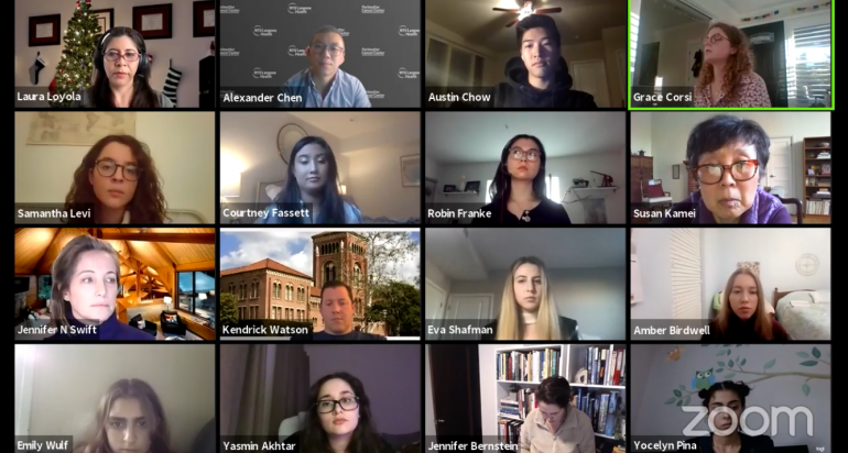

On Thursday, February 4, 2021, five recent graduates of the Spatial Sciences Institute (SSI) B.S. in GeoDesign program shared their academic and career advice with more than 40 current GeoDesign majors and interested students.
Participating were Alex Chen (B.S. GeoDesign, Minor in Public Health ’18), Grace Corsi (B.S. GeoDesign and B.A. Music (Jazz Voice) ’19), Courtney Fassett (B.S. GeoDesign, Minors in Applied Analytics and Spanish), Robin Franke (B.S. GeoDesign ’18) and Samantha Levi (B.S. GeoDesign ’20).
Dr. Laura C. Loyola, SSI Director of Undergraduate Studies, kicked off the discussion by asking the group what aspects of the GeoDesign degree have been the most helpful to them in their post-baccalaureate paths thus far?
 Alex shared that as he combined his GeoDesign degree with a minor in public health, he knew he wanted explore the relationship between health and place. He identified Columbia University’s Master of Public Health program in epidemiology as a way to deepen his understanding, and graduated from that program in 2020. He currently serves as a data analyst for NYU Langone Health’s City Health Dashboard, which provides multi-year data for 38 health metrics for more than 750 cities across the United States. Alex says he got his ideal job as a spatial epidemiologist because of the way that GeoDesign taught him how to integrate concepts and methodologies through interdisciplinary and multi-scalar ways.
 Grace concurred, saying her favorite aspect of the GeoDesign program is that she took away how to think across many disciplines. After graduating, she joined DLR Group, a large architecture and planning firm with headquarters in Los Angeles and numerous offices worldwide.
Grace has already received a promotion to GIS data analyst, and is working on a wide variety of the firm’s projects. Although she is neither an architect nor a planner in an architecture and planning firm, she has the command of the languages and approaches of both disciplines and is capable of working on projects in different contextual settings and scales.
Dr. Loyola asked the group how they decided to pursue either graduate school and/or a job.
 Courtney indicated that based upon her various research and internship opportunities, she was interested in business technology opportunities and felt that the GeoDesign major helped her bridge into that sector. Once she was offered a position with Deloitte Consulting in its Government and Public Services practice, she was excited to accept that offer and was ready to start her career. She is working as a strategy and analytics analyst and her current project is to work on a website that helps people sign up for the COVID vaccine. Courtney said, “You can own your career at Deloitte,” and appreciates having the opportunity for independence and to carve out her own professional path.
 Samantha similarly considered what she enjoyed the most about her course work, research and internship experiences, and realized she wanted to hone in on artistic and visualization techniques.
One conversation with a co-worker in her Esri internship led to a Google search, which led her to discovering the Erasmus Mundus scholarship program offered by the European Commission. Sam received an Erasmus Mundus scholarship for a two-year M.S. in Cartography program with the Technical University of Munich. Next semester she will study in Vienna, Austria.
 Robin’s post-baccalaureate path has already combined both professional experiences with graduate studies. The courses she liked the most in the GeoDesign curriculum were the planning courses, but she didn’t know what kind of planner she wanted to be. During her internship with LA Metro, Robin talked with co-workers and superiors about her interest in urban planning and learned that it would be important to get a master of planning degree. That knowledge helped motivate her to pursue the MPL in the USC Price School on a progressive degree path, which she obtained one year after graduating from the GeoDesign program. She now is working as a solution engineer with Esri on its ArcGIS Urban team.
All five concurred in the techniques they found to be effective in helping them identify opportunities. They highly recommended:
- doing internships with different kinds of organizations (e.g., one in the public sector and one in the private sector) or firms of different sizes or composition, to help you learn which you might prefer;
- using extracurricular activities as a way to get introduced to new opportunities (e.g., through her involvement with SC Mappers, Sam did a summer internship with YouthMappers with OpenStreetMap);
- not being afraid to make small talk with people at events; getting out of your comfort zone to connect with people on LinkedIn; going to career fairs and taking advantage of other campus resources (e.g., Grace learned about her firm through the School of Architecture career fair);
- doing your research and keep Googling;
- talking with your professors and superiors about your interests, as they could give you ideas, share your resume, and introduce you to the right people. For example, in one of Alex’s classes in the Columbia MPH program, a guest speaker indicated he needed an intern with GIS capabilities. Alex got the internship and his internship boss sent his CV to the person who is now his current boss;
- thinking outside the three boxes of GIS, planning, and architecture: there are so many opportunities in other fields for which GeoDesign is great preparation;
- getting involved in off-campus activities and adding to your network;
- listing your relevant GeoDesign courses and their short descriptions on your resume and tailoring the selection according to the position you’re applying for; and
- embracing the opportunity to explain to interviewers what is GeoDesign – be ready with a foundational explanation of the benefits of GeoDesign and then emphasize the aspects that relate to the specific opportunity you are applying for.
In concluding, Dr. Loyola asked the panelists what advice they would now give their GeoDesign major self?
Alex said he entered USC and college with an idea of what he wanted to do but without an idea of how to get there. As a result, he was oriented to looking ahead to what he needed to do next, and now wishes he also took the time to enjoy more of the moment. He said he learned from architecture concepts that even the smallest details need context to make sense, something that sticks with him every day while he is constructing code. Even though he would not have thought that architecture courses would help him in data analysis, they do; each course can teach a skill that can be applied outside of the classroom or subject area.
Robin shared that she now realizes that she should have taken the time to really understand what she was doing in the GIS lab assignments instead of just getting through them to get them done, as she had to go back and relearn.
Courtney said her father gave her wise advice while she was a college student. He urged her to use her college time according to “4 P’s”: to be positive, principled, proactive and productive. She followed his advice and would recommend these four principles to others.
For more information about the B.S. in GeoDesign program, visit https://spatial.usc.edu/undergraduate/b-s-in-geodesign/ or contact Ken Watson, Director of Academic Programs, at watsonke@usc.edu.

