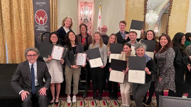
Student and alumni presentations
-
Arno Abrahamian (B.S. Geodesign student)
Intelligence Community Center for Academic Excellence 2024 Annual Colloquium, April 4, 2024, Los Angeles, California
Evolving BorderlandsEric Allen
US Geospatial Intelligence Foundation GEOINT Symposium, May 5, 2024, Orlando, Florida
A USC-NGA Tearline Collaboration Examining Emerging Trends in Post-Conflict Stabilization for Nagorno-Karabahk, Armenia and AzerbaijianShivi Anand (B.S. Global Geodesign student)
Los Angeles Geospatial Summit, February 23, 2024, Los Angeles, California
Ukraine: The World’s War-Torn Bread BasketIntelligence Community Center for Academic Excellence 2024 Annual Colloquium, April 4, 2024, Los Angeles, California
An Investigation into Food Security and Agricultural Production in War-Torn Ukraine Using Remote Sensing TechnologiesUS Geospatial Intelligence Foundation GEOINT Symposium, May 5, 2024, Orlando, Florida
An Investigation into Food Security and Agricultural Production in War-Torn Ukraine Using Remote Sensing TechnologiesAmber Birdwell (B.S. Global Geodesign and M.S. Geographic Information Science and Technology student)
Los Angeles Geospatial Summit, February 23, 2024, Los Angeles, California
USC Urban Trees Initiative 2023 and Prioritizing Local Action for Climate Equity: Strengthening Community Resilience Against Extreme Urban Heat in LAAmerican Association of Geographers Annual Meeting, April 19, 2024, Honolulu, Hawai’i
Building heat-resilient urban communities using mapping and geospatial technologiesDominic Borrelli (GIS and Sustainability Science minor)
Los Angeles Geospatial Summit, February 23, 2024, Los Angeles, California
USC Urban Trees Initiative 2023Eliot Breitowich
US Geospatial Intelligence Foundation GEOINT Symposium, May 5, 2024, Orlando, Florida
A USC-NGA Tearline Collaboration Examining Emerging Trends in Post-Conflict Stabilization for Nagorno-Karabahk, Armenia and AzerbaijianPhilippa Burgess (M.S. Human Security and Geospatial Intelligence student)
Los Angeles Geospatial Summit, February 23, 2024, Los Angeles, California
Port of Long Beach: Sustainability Analysis, Built with Cesium and ArcGIS Pro 3.2Intelligence Community Center for Academic Excellence 2024 Annual Colloquium, April 4, 2024, Los Angeles, California
Assessing Human Security Trends in Nagorno-Karabakh: A Collaboration with NGA TearlineUS Geospatial Intelligence Foundation GEOINT Symposium, May 5, 2024, Orlando, Florida
A USC-NGA Tearline Collaboration Examining Emerging Trends in Post-Conflict Stabilization for Nagorno-Karabahk, Armenia and AzerbaijianNaman Casas (M.S. Geographic Information Science and Technology student)
American Association of Geographers Annual Meeting, April 20, 2024, Honolulu, Hawai’i
Fusion Image Classification Approaches in Delineating Urban Tree Canopy in Unincorporated Los AngelesCerlinn Chill (M.S. Human Security and Geospatial Intelligence student)
Los Angeles Geospatial Summit, February 23, 2024, Los Angeles, California
Mapping Voices: Unraveling the Layers of GIS AwarenessIntelligence Community Center for Academic Excellence 2024 Annual Colloquium, April 4, 2024, Los Angeles, California
Assessing Human Security Trends in Nagorno-Karabakh: A Collaboration with NGA TearlineUS Geospatial Intelligence Foundation GEOINT Symposium, May 5, 2024, Orlando, Florida
A USC-NGA Tearline Collaboration Examining Emerging Trends in Post-Conflict Stabilization for Nagorno-Karabahk, Armenia and AzerbaijianShuyi Deng (M.S. Spatial Economics and Data Analysis student)
Los Angeles Geospatial Summit, February 23, 2024, Los Angeles, California
Air Pollution in California, 2022Sachin Dubey (Minor is Spatial Studies)
Intelligence Community Center for Academic Excellence 2024 Annual Colloquium, April 4, 2024, Los Angeles, California
Evolving BorderlandsHana Feingold (M.S. Human Security and Geospatial Intelligence student)
Los Angeles Geospatial Summit, February 23, 2024, Los Angeles, California
Ukraine: The World’s War-Torn Bread BasketIntelligence Community Center for Academic Excellence 2024 Annual Colloquium, April 4, 2024, Los Angeles, California
An Investigation into Food Security and Agricultural Production in War-Torn Ukraine Using Remote Sensing TechnologiesUS Geospatial Intelligence Foundation GEOINT Symposium, May 5, 2024, Orlando, Florida
An Investigation into Food Security and Agricultural Production in War-Torn Ukraine Using Remote Sensing TechnologiesUS Geospatial Intelligence Foundation GEOINT Symposium, May 5, 2024, Orlando, Florida
A USC-NGA Tearline Collaboration Examining Emerging Trends in Post-Conflict Stabilization for Nagorno-Karabahk, Armenia and AzerbaijianMia Fong (M.S. Spatial Economics and Data Analysis student)
Los Angeles Geospatial Summit, February 23, 2024, Los Angeles, California
Advancing USC Sustainability Goals Through Spatial AnalysisAvery Fratto (M.S. Spatial Data Science student)
Los Angeles Geospatial Summit, February 23, 2024, Los Angeles, California
USC Urban Trees Initiative 2023Jacob Gizamba (Population, Health and Place Ph.D. student)
American Association of Geographers Annual Meeting, April 18, 2024, Honolulu, Hawai’i
Establishing a Longitudinal Health Places Index for the United States: A Pilot Study of Los Angeles County (2004-2019)Nelson Henriquez (B.S. Geodesign student)
Los Angeles Geospatial Summit, February 23, 2024, Los Angeles, California
Prioritizing Local Action for Climate Equity: Strengthening Community Resilience Against Extreme Urban Heat in LA
American Association of Geographers Annual Meeting, April 19, 2024, Honolulu, Hawai’i
Building heat-resilient urban communities using mapping and geospatial technologiesErica Ho (Population, Health and Place Ph.D. student)
American Association of Geographers Annual Meeting, April 18, 2024, Honolulu, Hawai’i
Establishing a Longitudinal Health Places Index for the United States: A Pilot Study of Los Angeles County (2004-2019)David Jurbala
US Geospatial Intelligence Foundation GEOINT Symposium, May 5, 2024, Orlando, Florida
A USC-NGA Tearline Collaboration Examining Emerging Trends in Post-Conflict Stabilization for Nagorno-Karabahk, Armenia and AzerbaijianAndrew Kampfschulte (Population, Health and Place Ph.D. candidate)
Los Angeles Geospatial Summit, February 23, 2024, Los Angeles, California
Geographic Access to HealthAmerican Association of Geographers Annual Meeting, April 19, 2024, Honolulu, Hawai’i
The Geography of Healthcare: Transportation Burden and Access to CareKelly Kwok (B.S. Geodesign student)
Los Angeles Geospatial Summit, February 23, 2024, Los Angeles, California
Ambient Air Quality Exposure Among Pediatric Patients CHLAT. Monicque Lee (M.S. Geographic Information Science and Technology ’19)
American Association of Geographers Annual Meeting, April 16, 2024, Honolulu, Hawai’i
Developing Curricular Resources to Advance Human Security and Geospatial Intelligence: Challenges, Opportunities and Lessons LearnedNicholas Lee (M.S. Human Security and Geospatial Intelligence)
US Geospatial Intelligence Foundation GEOINT Symposium, May 5, 2024, Orlando, Florida
A USC-NGA Tearline Collaboration Examining Emerging Trends in Post-Conflict Stabilization for Nagorno-Karabahk, Armenia and AzerbaijianLeo Lerner (Population, Health and Place Ph.D. candidate)
Los Angeles Geospatial Summit, February 23, 2024, Los Angeles, California
Affective geographic information science: can visual carto-elicitation evoke the sensorimotor?Consortium of Universities for Global Health, March 7, 2024, Los Angeles, CA
Affective geographic information science: Using carto photo elicitation interviews (CPEI) to examine the connections between mobility and place amongst the carless in Los AngelesDaoyang Li (M.S. Spatial Data Science student)
Los Angeles Geospatial Summit, February 23, 2024, Los Angeles, California
GeoLocator: A novel GeoAI tool making world travel without barriersHaiyang Li (M.S. Spatial Data Science student)
Los Angeles Geospatial Summit, February 23, 2024, Los Angeles, California
Paradise on Fire – 2023 Hawaii Wildfire: Cost-Effective Rapid Wildfire AnalysisQuiluo Li (M.S. Spatial Data Science student)
Los Angeles Geospatial Summit, February 23, 2024, Los Angeles, California
Paradise on Fire – 2023 Hawaii Wildfire: Cost-Effective Rapid Wildfire AnalysisWanxin Li (M.S. Spatial Data Science student)
Los Angeles Geospatial Summit, February 23, 2024, Los Angeles, California
Tree Species Detection on CampusZongrong Li (M.S. Spatial Data Science student)
Los Angeles Geospatial Summit, February 23, 2024, Los Angeles, California
Paradise on Fire – 2023 Hawaii Wildfire: Cost-Effective Rapid Wildfire AnalysisKuan Hsien Lin (M.S. Spatial Data Science student)
Los Angeles Geospatial Summit, February 23, 2024, Los Angeles, California
Tree Species Detection on CampusPeter Lin (M.S. Spatial Data Science student)
Los Angeles Geospatial Summit, February 23, 2024, Los Angeles, California
Endangered Species in CaliforniaShaokun Lyu (M.S. Spatial Data Science student)
Los Angeles Geospatial Summit, February 23, 2024, Los Angeles, California
Endangered Species in CaliforniaNadia Makmak (Minor in Human Security and Geospatial Intelligence)
Intelligence Community Center for Academic Excellence 2024 Annual Colloquium, April 4, 2024, Los Angeles, California
Evolving BorderlandsLaura Messier (Population, Health and Place Ph.D. student)
American Association of Geographers Annual Meeting, April 16, 2024, Honolulu, Hawai’i
Imagining the Future of Green Infrastructure in Los Angeles
American Association of Geographers Annual Meeting, April 18, 2024, Honolulu, Hawai’i
Establishing a Longitudinal Health Places Index for the United States: A Pilot Study of Los Angeles County (2004-2019)Jonathan Palmer (M.S. Human Security and Geospatial Intelligence student)
Intelligence Community Center for Academic Excellence 2024 Annual Colloquium, April 4, 2024, Los Angeles, California
Assessing Human Security Trends in Nagorno-Karabakh: A Collaboration with NGA TearlineUS Geospatial Intelligence Foundation GEOINT Symposium, May 5, 2024, Orlando, Florida
A USC-NGA Tearline Collaboration Examining Emerging Trends in Post-Conflict Stabilization for Nagorno-Karabahk, Armenia and AzerbaijianKatherine Robinson (Minor in GIS and Sustainability Science)
Los Angeles Geospatial Summit, February 23, 2024, Los Angeles, California
Urban Green Space Access and Children’s Health; Nearby Nature Site Tour: A Symphony of Biodiversity; and Ambient Air Quality Exposure Among Pediatric Patients CHLAHan Shen (Population, Health and Place candidate)
American Association of Geographers Annual Meeting, April 18, 2024, Honolulu, Hawai’i
Defining Asian Enclaves in Los Angeles County: Mapping Population Clusters, Sociocultural Features, and Unraveling Health DisparitiesJacob Spear (M.S. Human Security and Geospatial Intelligence ’23)
US Geospatial Intelligence Foundation GEOINT Symposium, Orlando, Florida
Modern GEOINT Tradecraft Curriculum for Contemporary LearnersShuju Sun (M.S. Spatial Data Science student)
Los Angeles Geospatial Summit, February 23, 2024, Los Angeles, California
GeoLocator: A novel GeoAI tool making world travel without barriersSusan Tang (Minor in GIS and Sustainability Science)
Los Angeles Geospatial Summit, February 23, 2024, Los Angeles, California
Divisions Between USC and South Central Los Angeles: Impacts of Campus Safety Policy MeasuresPhilippe Tousignant (M.S. Human Security and Geospatial Intelligence)
US Geospatial Intelligence Foundation GEOINT Symposium, May 5, 2024, Orlando, Florida
A USC-NGA Tearline Collaboration Examining Emerging Trends in Post-Conflict Stabilization for Nagorno-Karabahk, Armenia and AzerbaijianLeyna Tran (B.S. Geodesign student)
Los Angeles Geospatial Summit, February 23, 2024, Los Angeles, California
Divisions Between USC and South Central Los Angeles: Impacts of Campus Safety Policy MeasuresHaley Veach (M.S. Human Security and Geospatial Intelligence student)
Los Angeles Geospatial Summit, February 23, 2024, Los Angeles, California
Ukraine: The World’s War-Torn Bread BasketIntelligence Community Center for Academic Excellence 2024 Annual Colloquium, April 4, 2024, Los Angeles, California
An Investigation into Food Security and Agricultural Production in War-Torn Ukraine Using Remote Sensing Technologies
US Geospatial Intelligence Foundation GEOINT Symposium, May 5, 2024, Orlando, Florida
An Investigation into Food Security and Agricultural Production in War-Torn Ukraine Using Remote Sensing TechnologiesAviva Wolf-Jacobs (Population, Health and Place candidate)
American Association of Geographers Annual Meeting, April 18, 2024, Honolulu, Hawai’i
Community Climate Action MappingIskar Waluyo (Population, Health and Place Ph.D. student)
American Association of Geographers Annual Meeting, April 17, 2024, Honolulu, Hawai’i
Assessing Los Angeles’ Creative Economy Network
American Association of Geographers Annual Meeting, April 18, 2024, Honolulu, Hawai’i
Establishing a Longitudinal Health Places Index for the United States: A Pilot Study of Los Angeles County (2004-2019)Jiahao Wang (Population, Health and Place Ph.D. student)
American Association of Geographers Annual Meeting, April 18, 2024, Honolulu, Hawai’i
Establishing a Longitudinal Health Places Index for the United States: A Pilot Study of Los Angeles County (2004-2019)
American Association of Geographers Annual Meeting, April 20, 2024, Honolulu, Hawai’i
Identify Neighborhood Archetypes for the Health, Development and Wellbeing of Youth in the US Metropolitan AreasMengya Xu (Population, Health and Place Ph.D. candidate)
Los Angeles Geospatial Summit, February 23, 2024, Los Angeles, California
Transit as Public Good: How far are we from a competitive transit system in fostering everyday mobility in Los Angeles County?
American Association of Geographers Annual Meeting, April 16, 2024, Honolulu, Hawai’i
Navigating Foodscapes: A Multifaceted Exploration of Food Accessibility, Transportation Infrastructure, and Definitions of Food Outlet Constructs Across Socio-Demographic DividesShuo Yan (M.S. Spatial Data Science student)
Los Angeles Geospatial Summit, February 23, 2024, Los Angeles, California
Endangered Species in CaliforniaYifan Yang (M.S. Spatial Data Science student)
Los Angeles Geospatial Summit, February 23, 2024, Los Angeles, California
Urban Tree Shade Model and GeoLocator: A novel GeoAI tool making world travel without barriers -
Paula Acedo (B.S. Geodesign student)
Los Angeles Geospatial Summit, February 24, 2023, Los Angeles, California
USC x South Central: Bridging the GapShivi Anand (B.S. Global Geodesign student)
Los Angeles Geospatial Summit, February 24, 2023, Los Angeles, California
USC x South Central: Bridging the GapJustice Batiste (M.S. Geographic Information Science and Technology student)
Los Angeles Geospatial Summit, February 24, 2023, Los Angeles, California
Post Disaster Imagery Collection Based on the US National GridAndrew Bawiec (B.A. Environmental Studies, Minor in GIS and Sustainability Science student)
USC Undergraduate Symposium for Scholarly and Creative Work, April 12, 2023, Los Angeles, California
USC Sustainability Data Hub: Phase 2Amber Birdwell (B.S. Global Geodesign ’23)
Los Angeles Geospatial Summit, February 24, 2023, Los Angeles, California
Satellite Imagery Housing Classification Methodology in Bangalore, IndiaIsabela Camerino
Los Angeles Geospatial Summit, February 24, 2023, Los Angeles, California
Site Suitability Moving to Puerto RicoJoseph Canas (M.S. Geographic Information Science and Technology student)
Los Angeles Geospatial Summit, February 24, 2023, Los Angeles, California
GEOINT Foreword, United States Geospatial Intelligence Foundation, May 21, 2023, St. Louis, Missouri
Post Disaster Imagery Collection Based on the US National GridNaman Casas (B.S. Geodesign ’22; M.S. in Geographic Information Science and Technology ’23)
Los Angeles Geospatial Summit, February 24, 2023, Los Angeles, California
Urban Trees Initiative’s Urban Canopy and Shade Modeling ProjectEileen Baoqi Chen (B.A. Journalism; B.S. Environmental Studies; Minor in GIS and Sustainability Science ’23)
Los Angeles Geospatial Summit, February 24, 2023, Los Angeles, California
USC Undergraduate Symposium for Scholarly and Creative Work, April 12, 2023, Los Angeles, California
Enhanced Pedestrian Traffic Modeling: Applications of ArcPy
A Two-step Floating Catchment Area (2SFCA) Method to Evaluate Electric Vehicle Infrastructure Accessibility in Los AngelesUSC Undergraduate Symposium for Scholarly and Creative Work, April 12, 2023, Los Angeles, California
USC Urban Trees InitiativeWanlin Chen (M.S. Spatial Economics and Data Analysis ’23)
Los Angeles Geospatial Summit, February 24, 2023, Los Angeles, California
COVID-19 and Housing Price Effects: Spatial Error with Spatial Regime ModelCoco Zhiyang Cheng (M.S. Spatial Economics and Data Analysis ’23)
Los Angeles Geospatial Summit, February 24, 2023, Los Angeles, California
The Environmental Cost of Economic Development for the European UnionJunhong Duan (M.S. Spatial Data Science ’23)
Los Angeles Geospatial Summit, February 24, 2023, Los Angeles, California
Promotores de Salud: Making Culturally Tailored Health Interventions in Latine CommunitiesKrissie Essilfie (B.S. Geodesign student)
Los Angeles Geospatial Summit, February 24, 2023, Los Angeles, California
Sheltering San Francisco- Analyzing Site Suitability for Permanent Supportive HousingAlyssa Felix-Arreola (B.S. Global Health; GIS and Sustainability Science Minor ’23)
Los Angeles Geospatial Summit, February 24, 2023, Los Angeles, California
Promotores de Salud: Making Culturally Tailored Health Interventions in Latine CommunitiesDanyu Huang (M.S. Spatial Economics and Data Analysis ’23)
Los Angeles Geospatial Summit, February 24, 2023, Los Angeles, California
Geographic variation associated with lung cancer in KentuckyIsabella Gonzalez (B.S. Geodesign student)
USC Undergraduate Symposium for Scholarly and Creative Work, April 12, 2023, Los Angeles, California
The Great Redwood Trail: Mapping Northern California’s Repurposed TrailsJillian Gorman (B.S. Narrative Studies; Minor in Environmental Studies student)
USC Undergraduate Symposium for Scholarly and Creative Work, April 12, 2023, Los Angeles, California
USC Urban Trees InitiativeJulian Kaiser (B.S. Urban Studies and Planning student)
USC Undergraduate Symposium for Scholarly and Creative Work, April 12, 2023, Los Angeles, California
The Great Redwood Trail: Mapping Northern California’s Repurposed TrailsRunzi Kang (M.S. Spatial Economics and Data Analysis ’23)
Los Angeles Geospatial Summit, February 24, 2023, Los Angeles, California
Urban Trees Initiative’s Urban Canopy and Shade Modeling ProjectCarolyn Koh (B.S. Geodesign; B.S. Urban Studies and Planning ’23)
Los Angeles Geospatial Summit, February 24, 2023, Los Angeles, California
Is Singapore a 15-minute city? — Bridging gaps between demand and supply of urban services
Urban Trees Initiative’s Urban Canopy and Shade Modeling Project
USC Undergraduate Symposium for Scholarly and Creative Work, April 12, 2023, Los Angeles, California
USC Urban Trees InitiativePeiyao Li
Los Angeles Geospatial Summit, February 24, 2023, Los Angeles, California
Spatial Prediction of Housing Prices in Beijing, ChinaViolet Shiqi Li (M.S. Spatial Data Science ’23)
Los Angeles Geospatial Summit, February 24, 2023, Los Angeles, California
An Overview of the USC GeoHealth HubNadia Makmak (B.A. International Relations; Minor in Human Security and Geospatial Intelligence student)
USC Undergraduate Symposium for Scholarly and Creative Work, April 12, 2023, Los Angeles, California
USC Sustainability Data Hub: Phase 2Joey Newell (B.S. Geodesign; Minor in Real Estate Development student)
Los Angeles Geospatial Summit, February 24, 2023, Los Angeles, California
USC x South Central: Bridging the GapAlyssa Ng (B.S. Environmental Studies, Spatial Studies minor student)
Los Angeles Geospatial Summit, February 24, 2023, Los Angeles, California
Enhanced Pedestrian Traffic Modeling: Applications of ArcPyUSC Undergraduate Symposium for Scholarly and Creative Work, April 12, 2023, Los Angeles, California
USC Urban Trees InitiativeTristan Pekron (M.S. Human Security and Geospatial Intelligence ’23)
Los Angeles Geospatial Summit, February 24, 2023, Los Angeles, California
Post Disaster Imagery Collection Based on the US National GridGEOINT Foreword, United States Geospatial Intelligence Foundation, May 21, 2023, St. Louis, Missouri
Amanda Rago (M.S. Spatial Economics and Data Analysis ’23)
Los Angeles Geospatial Summit, February 24, 2023, Los Angeles, California
An Overview of the USC GeoHealth HubKatherine Robinson (B.S. Environmental Studies; GIS and Sustainability Science Minor student)
Los Angeles Geospatial Summit, February 24, 2023, Los Angeles, California
Measuring Arthropod Biodiversity at USCIskar Waluyo (Ph.D. student, Population, Health and Place)
Los Angeles Geospatial Summit, February 24, 2023, Los Angeles, California
Market Murals in Mexico CityMengya Xu (Ph.D. candidate, Population, Health and Place)
Association of Pacific Coast Geographers Conference, October 21, 2023, Ventura, California
New Insights Into Grocery Store Visits Among East Los Angeles Residents Using Mobility Data -
Joseph C. Toland (M.S. GIST ’18) and An-Min Wu
American Association of Geographers Annual Meeting, February 27, 2022
“A New Transportation Disruption Metric for Household Food and Water Resource Accessibility After Earthquakes” -
Bita Minaravesh (Ph.D. candidate, Population, Health and Place)
American Association of Geographers Annual Meeting, April 11, 2021
“Using Space-Time Regression to Model the Impact of Natural Environmental Determinants on Childhood Academic Performance”Emily Serman (Ph.D. candidate, Population, Health and Place), Kate Vavra-Musser (Ph.D. candidate, Population, Health and Place), and Rachel Wilkie (Ph.D. student, Population, Health and Place)
American Association of Geographers Annual Meeting, April 11, 2021
“Heat Index Burden for Older Populations in the Contiguous United States – The Case for an Age-Specific Analysis”Li Yi (Ph.D. candidate, Population, Health and Place)
American Association of Geographers Annual Meeting, April 10, 2021
“Integrating Mobility and Time-Activity Patterns in Assessing Environmental Exposures During Pregnancy and Early Postpartum”Mengya Yu (Ph.D. student, Population, Health and Place), Jasmine Wu (B.S. GeoDesign, Minor, Architecture ’21) and team
American Association of Geographers Annual Meeting, April 10, 2021
“The Landscape of Health Behavior Bads in Greater Los Angeles: Estimating Population Exposure with Local Colocation Quotients”Yan Xu (Ph.D. candidate, Population, Health and Place)
American Association of Geographers Annual Meeting, April 9, 2021
“Examining the Impact of Individual Time-Activity Patterns in Real-Time Personal PM2.5 Exposures of Low-income Hispanic Pregnant Women in Los Angeles, CA”Avery Everhart (Ph.D. candidate, Population, Health and Place)
American Association of Geographers Annual Meeting, April 9, 2021, “A Human Rights-based Approach to Measuring Geographic Access to and Availability of Transgender Healthcare”; April 8, 2021
“More than Mentoring: Towards A More Equitable and Just Geography”Cameron Audras (Jennifer Swift and Jennifer Bernstein research team)
American Association of Geographers Annual Meeting, April 7, 2021
“Investigating Industrial-Scale Solar Energy in Southeastern California Using Mixed Methodologies”Kate Vavra-Musser (Ph.D. candidate, Population, Health and Place) and team
American Association of Geographers Annual Meeting, April 7, 2021
“Source Contribution to Soil Lead Contamination – the Role of Common Urban Residential Lead Sources and Major Industrial Sources in a Complex Urban Residential Environment”Kristin Wong (Jennifer Swift research team)
American Association of Geographers Annual Meeting, April 7, 2021
“Geovisualization of the Ice Age at The La Brea Tar Pits, Los Angeles, California”Alicia Adiwidjaja (B.S. GeoDesign student) and Adam Owens (B.S. GeoDesign student)
Los Angeles Geospatial Summit, February 25, 2021
“Collaborative Project to Tackle Improving Response Time on LA County Hiking Trails”Cameron Audras (Jennifer Bernstein research team)
Los Angeles Geospatial Summit, February 25, 2021
“Investigating Industrial-scale Solar Energy in Southeastern California Using Mixed Methodologies”Jackson FitzGerald, Lilly Nie, and Sarah Ta (2019-2020 Geodesign Fellows)
Los Angeles Geospatial Summit, February 25, 2021
“Using Geodesign to Model the Health Impacts of New Urban Design Interventions”Cameron Levine (B.S. GeoDesign ’21)
Los Angele Geospatial Summit, February 25, 2021
“Detecting Fallow Fields in Europe Using Remote Sensing and Maximum Entropy Modeling”Michelle Livings (Ph.D. student, Population, Health and Place)
Los Angeles Geospatial Summit, February 25, 2021
“Disrupted Society, Decreased Traffic Collisions: Spatiotemporal Change-Point Analysis of Traffic Collisions in Los Angeles During COVID-19”Bryna Mills (M.S. GIST ’21)
Los Angeles Geospatial Summit, February 25, 2021
“Spatiotemporal Analysis of Snow Crab in the Eastern Bering Sea”Seher Randhawa (B.S. Business Administration, Minor in Spatial Studies ’21), Erik Huisman (B.S. GeoDesign student), Rachel Ablondi (B.S. GeoDesign; Minor, Landscape Architecture ’21), Jackson FitzGerald (2019-2020 Geodesign Fellow)
Los Angeles Geospatial Summit, February 25, 2021
“Urban Trees Initiative”Kate Vavra-Musser (Ph.D. candidate, Population, Health and Place)
Los Angeles Geospatial Summit, February 25, 2021
“Source Contribution to Soil Lead Contamination – the Role of Common Urban Residential Lead Sources and Major Industrial Sources in a Complex Urban Residential Environment”Kristin Wong (Jennifer Swift research team)
Los Angeles Geospatial Summit, February 25, 2021
“The La Brea Tar Pits: An Ice Age Storymap”Emily Serman (Ph.D. candidate, Population, Health and Place) and Kate Vavra-Musser (Ph.D. candidate, Population, Health and Place
Los Angeles Geospatial Summit, February 25, 2021
“Heat Index Burden for Older Populations in the Contiguous United States – The Case for an Age-Specific Analysis”Eliza Gutierrez-Dewar (B.S. GeoDesign, Minor, Architecture ’19)
Esri Geodesign Summit, February 9, 2021
“Building Conservation Resiliency with Geodesign”Eliza Gutierrez-Dewar (B.S. GeoDesign, Minor, Architecture ’19)
Esri Geodesign Summit, February 8, 2021 and February 11, 2021
“Analyzing and Comparing Planning Scenarios”Robin Franke (B.S. GeoDesign ’18)
Esri Geodesign Summit, February 8, 2021
“Creating and Sharing Awesome 3D Web Scenes” -
Yueqi Gu (M.S. Spatial Data Science student), Jacqueline Sosa (B.S. GeoDesign ’20) and Orhun Aydin
American Geophysical Union (AGU) Fall Meeting, December 1, 2020
“Democratizing Safety During an Earthquake: Multi-Disciplinary Spatial Optimization for Defining Evacuation Centers with Fair Access in L.A. County”Bita Minaravesh (Ph.D. candidate, Population, Health and Place) and Orhun Aydin
American Geophysical Union (AGU) Fall Meeting, December 1, 2020
“A Random Forest Based Spatiotemporal Regression Model for the Impact of Greenspace on Childhood Academic Performance
Modeling Mobility Patterns Uncertainty of Twitter Feeds During an Earthquake Using Spatio-Temporal Point Process Models”Bita Minaravesh (Ph.D. candidate, Population, Health and Place) and Orhun Aydin
Center for Spatial Studies, University of California, Santa Barbara “Reasoning in GeoAI” Mini-Workshop, October 21, 2020
“A Random Forest Based Spatiotemporal Regression Model for the Impact of Green Space on Childhood Academic Performance”Christina Brunsvold (M.S. GIST ’19)
URISA GIS-Pro Conference, September 29, 2020
“Building the Perfect Combination of Education and Skillsets”Rachel Rodriguez (M.S. GIST ’15)
URISA GIS-Pro Conference, September 29, 2020
“Building the Perfect Combination of Education and Skillsets”Jackson FitzGerald (B.S. Environmental Studies; B.A. Archaeology ‘22; 2019-2020 SSI Geodesign Fellow)
URISA GIS-Pro Conference, September 29, 2020
“Modeling the Health Impacts of New Urban Design Interventions”John Pedersen (M.S. HSGI ’20)
US Geospatial Intelligence Foundation GEOINTegration Summit, September 28, 2020
“Development of an Operations Dashboard Suite to Support COVID-19 Emergency Management Efforts for US Army Corps of Engineers, Los Angeles”Kevin Mercy (M.S. Geographic Information Science and Technology ’20; B.A. in Interdisciplinary Archaeology; Minors in Computer Programming and Geospatial Intelligence)
US Geospatial Intelligence Foundation GEOINTegration Summit, September 28, 2020
“Comparing 3D Point Clouds in the Web: A Cloud Based Approach”Mia Poynor (B.S. Health and Human Sciences; Minors in Geospatial Intelligence and Spatial Studies ‘19)
US Geospatial Intelligence Foundation GEOINTegration Summit, September 28, 2020
“Leveraging Personal Electronic Device (PED) Data to Investigate Federalism and Inequality in a Pandemic”Jacqueline Sosa (B.S. GeoDesign ’20)
Association of Environmental and Engineering Geologists Annual Meeting, September 18, 2020
“Preparing for The Big One: Data-Driven Spatio-Temporal Risk Maps for Earthquake Evacuation in L.A. County”Young-Kyung Kim (B.A. International Relations and Affairs; B.S. Computational Linguistics ’21; Minor in Human Security and Geospatial Intelligence)
US Geospatial Intelligence Foundation GEOINTegration Summit, September 28, 2020
“Detecting Destroyed Communities in Remote Areas with Personal Electronic Device Data; a Case-Study of the 2017 Puebla Earthquake”Lourdes Johanna Avelar Portillo (Ph.D. Population, Health and Place candidate)
American Association of Geographers Annual Meeting, April 6, 2020
“Water Insecurity and Homeless Encampments in Los Angeles, California”Emmanuel Carrera Rueda (B.S. GeoDesign ’20)
Los Angeles Geospatial Summit, February 28, 2020
“Superblocks in Los Angeles”Charles Convery (B.A. International Relations, Minor in Human Security and Geospatial Intelligence student)
Los Angeles Geospatial Summit, February 28, 2020
“Using Game Engines and GIS to Visualize Fossils and Stratigraphy of the La Brea Tar Pits”Charmaine Dalisay (B.S. GeoDesign student)
American Association of Geographers Annual Meeting, April 6, 2020
“Solar Development in Southeastern California: A field-based learning experience combining quantitative and qualitative methodologies”
Los Angeles Geospatial Summit, February 28, 2020
“Story Mapping Solar Development in Southeastern California: A Field-Based Learning Experience Combining Quantitative and Qualitative Methodologies”Amelia Danholm-Pearce (B.S. GeoDesign student)
Los Angeles Geospatial Summit, February 28, 2020
“Assessing the Biological Success of Marine Protected Areas Along Central California’s Coastline”Peter Elliott (Graduate Certificate in Geospatial Intelligence ’19)
Los Angeles Geospatial Summit, February 28, 2020
“Graffiti, Crime, and Broken Windows: A Geospatial Exploration”Sara Evanoff (M.S. GIST ’19)
Los Angeles Geospatial Summit, February 28, 2020
“An exploration and assessment of bias within fossil prediction models using geographic information systems and geostatistical tools”Jackson FitzGerald (B.S. Environmental Studies; B.A. Archaeology, Minor in Spatial Studies student)
International Geodesign Collaboration, February 23, 2020
“Evaluating the Feasibility of Implementing Superblocks in LA”Nicholas Foster (B.A. Environmental Studies, Minor in GIS and Sustainability Science ‘20)
Los Angeles Geospatial Summit, February 28, 2020
“Catalina Seawall Photogrammetry: Temporal Algal Composition Observation”Autumn Gupta (B.S. GeoDesign; B.A. Environmental Studies ‘20)
Los Angeles Geospatial Summit, February 28, 2020
“Leveraging GIS to Enhance Immigration Services”Elin Henningsson (M.S. Human Security and Geospatial Intelligence ’19)
Los Angeles Geospatial Summit, February 28, 2020
“Forward support: cloud-based mosaic imagery for emergency operations”Jennifer Horowitz (M.S. GIST student)
Los Angeles Geospatial Summit, February 28, 2020
“Paradise Lost: Spatiotemporal Analysis of Declassified CIA Satellite Imagery to Understand the Extent of Ecological and Human Destruction in the Southern Iraqi Marshland”Erik Huisman (B.S. GeoDesign student)
Los Angeles Geospatial Summit, February 28, 2020
“Using Game Engines and GIS to Visualize Fossils and Stratigraphy of the La Brea Tar Pits”Elisha Ibanga (M.S. Human Security and Geospatial Intelligence ’19)
Los Angeles Geospatial Summit, February 28, 2020
“Forward support: cloud-based mosaic imagery for emergency operations”Andrew Leung (B.S. GeoDesign student)
Los Angeles Geospatial Summit, February 28, 2020
“Resilient LA: Leveraging Geospatial Applications to Build Neighborhood Resilience”Cameron Levine (B.S. GeoDesign student)
Los Angeles Geospatial Summit, February 28, 2020
“Characterizing long term and seasonal vegetation change in Los Angeles County using NDVI and tree cover”Lilly Nie (B.S. Urban Planning, Minor in Spatial Studies student)
International Geodesign Collaboration, February 23, 2020
“Evaluating the Feasibility of Implementing Superblocks in LA”Cari Porter (M.S. GIST ’20)
Los Angeles Geospatial Summit, February 28, 2020
“Residual Flood Risk and Social Vulnerability in the Sacramento and San Joaquin Delta Area”John Smith Mason (M.S. GIST ’20)
Los Angeles Geospatial Summit, February 28, 2020
“Multi-Criteria Site Selection for Innovative Wind Turbine in Urban Environment”Seher Randhawa (B.S. Business Administration, Minor in Spatial Studies student)
Los Angeles Geospatial Summit, February 28, 2020
“Resilient LA: Leveraging Geospatial Applications to Build Neighborhood Resilience”Chris Sanders (M.S. GIST ’20)
Los Angeles Geospatial Summit, February 28, 2020
“Beyond Visual Line of Sight Commercial Unmanned Aircraft Operations: Site Suitability for Landing Zone Locations”Sarah Ta (B.S. GeoDesign, Minor in East Asian Languages and Cultures student)
International Geodesign Collaboration, February 23, 2020
“Evaluating the Feasibility of Implementing Superblocks in LA”Jasmine Siyu Wu (B.S. GeoDesign, Minor in Architecture student)
American Association of Geographers Annual Meeting, April 10, 2020
“Physical Accessibility of California Populations to Licensed and Unlicensed Cannabis Retail Facilities: Implications for Health Equity and Enforcement” -
Santina Benincasa (M.S. GIST student)
Bronx Community College Geospatial Center of the CUNY Remote Sensing Earth Systems (CREST) Institute (BGCCCI) NSF and NASA Spring 2019 Workshops, April 28, 2019, New York, New York
“Shoreline Erosion, Biodiversity Loss, and Salt Marsh Depletion in Jamaica Bay, NY after Hurricane Sandy”Emmanuel Carrera Ruedas (B.S. GeoDesign student)
2019 Esri User Conference Map Gallery, July 8, 2019 and USC Provost’s 2019 Undergraduate Symposium for Scholarly and Creative Work, April 10, 2019, Los Angeles, California
“Superblocks for Los Angeles: Sustainable Urban Alternatives Evaluated with GeoDesign”Austin Chow (B.S. GeoDesign ’19)
2019 Esri User Conference Map Gallery, July 8, 2019 and the USC Provost’s 2019 Undergraduate Symposium for Scholarly and Creative Work, April 10, 2019, Los Angeles, California
“The Macro of Micro: A Geospatial Exploration of Economic Development’s Effect on Small Business Vitality in Los Angeles”Grace Corsi (B.S. GeoDesign ‘19; B.A. Vocal Performance ‘19)
Los Angeles Geospatial Summit, February 20, 2019
“Changing Our Global Infrastructure in East Los Angeles, California: An International Collaborative Geodesign Studio”International Geodesign Collaboration, February 25, 2019
“NE Los Angeles Climate Change Adaptation”2019 Esri User Conference, July 9, 2019
“International Geodesign Collaboration: A New Mode of Data-Driven Discovery”Jenora D’Acosta (M.S. GIST ’15)
2019 Esri User Conference, July 9, 2019
“From Means and Medians to Machine Learning: Spatial Statistics Basics and Innovations”2019 Esri User Conference, July 10-11, 2019
“Beyond Where: Modeling Spatial Relationships and Making Predictions”Kenneth Egelkrout (Spatial Studies Minor ’19)
2019 Esri User Conference Map Gallery, July 8, 2019
“Soil Arsenic Pollution at Residences Near Exide Battery Recycling Plant in Vernon, California”USC Provost’s 2019 Undergraduate Symposium for Scholarly and Creative Work, April 10, 2019, Los Angeles, California
“Soil Arsenic Pollution at Residences Near Exide Battery Recycling Plant”Jiawen Fang (Ph.D. student, Urban Planning and Development; Graduate Certificate in Spatial Analytics)
2019 Esri User Conference Map Gallery, July 8, 2019
“The Spatial Dynamics of Amazon Lockers in Los Angeles County”Benjamin Friedman (B.S. GeoDesign ’19)
International Geodesign Collaboration, February 25, 2019
“NE Los Angeles Climate Change Adaptation”2019 Esri User Conference, July 9, 2019
“International Geodesign Collaboration: A New Mode of Data-Driven Discovery”Julia Fruithandler (B.S. GeoDesign ’19)
International Geodesign Collaboration, February 25, 2019
“NE Los Angeles Climate Change Adaptation”2019 Esri User Conference, July 9, 2019
“International Geodesign Collaboration: A New Mode of Data-Driven Discovery”Shea Ellen Gilliam (Ph.D. Population, Health and Place student)
American Association of Geographers Annual Meeting
“Reclaiming Critical Space in the Academy”Felix Goldwasser (B.S. GeoDesign student)
International Geodesign Collaboration, February 25, 2019
“NE Los Angeles Climate Change Adaptation”Jenna Gray (B.S. GeoDesign ’19)
Los Angeles Geospatial Summit, February 20, 2019
“LA ROSAH – Affordable Housing and Open Space Development Analysis”2019 Esri User Conference Map Gallery, July 8, 2019
“LA ROSAH Affordable Housing and Open Space Site Identification Analysis”Lindsay Hennes (M.S. GIST ’19)
2019 Esri Ocean and Atmospheric GIS Forum, November 6, 2019
“Spatiaotemporal Analysis of Long Times-Series Multidimensional Hydrographic Data”California Cooperative Oceanic Fisheries Investigations (CalCOFI) 70th Anniversary Annual Oceanography Symposium, December 2, 2019
“Increase in Surface Temperature and Deep Layer Nitrate in the California Current: A Spatiotemporal Analysis of Four-Dimensional Hydrographic Data”Elisha Ibanga (Graduate Certificate in Geospatial Intelligence ’18; M.S. Human Security and Geospatial Intelligence ’19)
United States Geospatial Intelligence Foundation 2019 GEOINT Foreword, June 2, 2019
“Leveraging Artificial Intelligence: Working with GEOINT as a Forecasting Tool”United States Geospatial Intelligence Foundation 2019 GEOINTegration, September 27, 2019
“Young Professionals Panel Discussion: What You Need to Know for Success”
“From Forecasting to Precognition: AI and Emergency Management”Jong Su (Yuma) Kim (B.S. International Relations; M.S. Human Security and Geospatial Intelligence student)
USC Provost’s 2019 Undergraduate Symposium for Scholarly and Creative Work, April 10, 2019, Los Angeles, California
“Detecting Village Burnings with High-Cadence SmallSats: a case-study in the Rakhine State of Myanmar”Young-Kyung Kim (B.A. International Relations; B.S. Computational Linguisitics; Minor, Human Security and Geospatial Intelligence student)
Los Angeles Geospatial Summit, February 20, 2019
“Detecting Village Burnings with High-Cadence SmallSats; a case-study in the Rakhine State of Myanmar”Harrison J. Knapp (B.S. GeoDesign; B.A. Earth Sciences student)
Los Angeles Geospatial Summit, February 20, 2019
“Characterizing light pollution along the Southern California coast using hemispherical photography”Eunbyul Abigail Koh (B.A. International Relations and East Asian Languages and Culture, Human Security and Geospatial Intelligence Minor ’19, magna cum laude)
David BorenZoe Lee (B.S. GeoDesign student)
2019 Esri User Conference Map Gallery, July 8, 2019 and the USC Provost’s 2019 Undergraduate Symposium for Scholarly and Creative Work, April 10, 2019, Los Angeles, California
“The Macro of Micro: A Geospatial Exploration of Economic Development’s Effect on Small Business Vitality in Los Angeles”Samantha Levi (B.S. GeoDesign student)
Los Angeles Geospatial Summit, February 20, 2019
“Investigating Submarine Groundwater Discharge on Santa Catalina Island, CA”USC Provost’s 2019 Undergraduate Symposium for Scholarly and Creative Work, April 10, 2019, Los Angeles, California
“Detecting and Characterizing Submarine Groundwater Discharge (SGD) on Santa Cantalina Island, CA”Cameron Levine (B.S. GeoDesign student)
USC Provost’s 2019 Undergraduate Symposium for Scholarly and Creative Work, April 10, 2019, Los Angeles, California
“A study on property values in residential areas in Los Angeles”Kevin Mercy (B.A. Interdisciplinary Archaeology; Minor in Human Security and Geospatial Intelligence; M.S. GIST student)
United States Geospatial Intelligence Foundation 2019 GEOINT Symposium, June 4, 2019
“A Lightweight, Robust Exploitation System for Temporal Stacks of UAS Data: Use Case for Forward-Deployed Military or Emergency Responders”United State Geospatial Intelligence Foundation 2019 GEOINTegration, September 27, 2019
“What Brought You to GEOINT?”
“A Lightweight, Robust Exploitation System for Temporal Stacks of UAS Data: Use Case for Forward-Deployed Military or Emergency Responders”Anthony Mosinski (M.S. GIST student)
Ohio Wildlife Management Association Conference, January 18, 2019, Columbus, Ohio
“Risk Assessment to Wildlife from Ohio’s Wind Energy Development: A Landscape Model Approach”Lilly Nie (B.S. Urban Planning; Spatial Studies Minor student)
2019 Esri User Conference Map Gallery, July 8, 2019 and the USC Provost’s 2019 Undergraduate Symposium for Scholarly and Creative Work, April 10, 2019, Los Angeles, California
“Superblocks for Los Angeles – Sustainable Urban Alternatives Evaluated with GeoDesign”Emily Nixon (B.S. Biological Sciences ’19)
USC Provost’s 2019 Undergraduate Symposium for Scholarly and Creative Work, April 10, 2019, Los Angeles, California
“The effect of point source pollution on the health and resilience of the Southern California kelp forest ecosystem”Torie Oulie (M.S. GIST ’18)
Los Angeles Geospatial Summit, February 20, 2019
“Coastal Vulnerability Assessment for Archaeological Sites on San Clemente Island and San Nicolas Island, California”Lois A. Park (Ph.D. Population, Health and Place student)
International Cartographic Conference, Tokyo, Japan, July 18, 2019
“Subnational estimates of health in low- and middle-income countries: a geospatial approach with interpolation and raster analysis”Mia Poynor (Human Security and Geospatial Intelligence Minor, Spatial Studies Minor ’20)
USC Provost’s 2019 Undergraduate Symposium for Scholarly and Creative Work, April 10, 2019, Los Angeles, California
“Detecting Village Burnings with High-Cadence SmallSats: a case-study in the Rakhine State of Myanmar”Michael Quant (M.S. GIST ’16)
2019 Esri User Conference, July 10, 2019
“Los Angeles Metro’s DigAlert Team Benefits from ArcGIS Spatial Conversion”Seher Randhawa (Spatial Studies Minor ’20)
USC Provost’s 2019 Undergraduate Symposium for Scholarly and Creative Work, April 10, 2019, Los Angeles, California
“Community Science Tree Inventory: Spatial Analysis of the Los Angeles Urban Forest”Sarah Rosenthall (M.S. GIST ’20)
2019 Esri User Conference Map Gallery, July 8, 2019
“Phoenix Islands Protected Area: A Natural Laboratory for Global Change”2019 Esri Ocean and Atmospheric GIS Forum, November 5, 2019
“Soundscapes: Exploring the Ocean Through Acoustics”Jacqueline Sosa (B.S. GeoDesign ’20)
USC Provost’s 2019 Undergraduate Symposium for Scholarly and Creative Work, April 10, 2019, Los Angeles, California
“A study on property values in residential areas in Los Angeles”Jingran (Cici) Tao (B.S. GeoDesign ’20, M.S. Spatial Economics and Data Analysis student)
USC Provost’s 2019 Undergraduate Symposium for Scholarly and Creative Work, April 10, 2019, Los Angeles, California
“Community Science Tree Inventory: Spatial Analysis of the Los Angeles Urban Forest”Joseph Toland (M.S. GIST ’19)
US Geological Survey Western Geographic Science Center (WGSC) Science Seminar, June 17, 2019, Menlo Park, California
“Modeling Emergency Logistical Resource Requirements for the ShakeOut and HayWired Scenarios”Alexander Toy (M.S. GIST student)
2019 Esri User Conference Map Gallery, July 8, 2019
“The John Muir Trail”Adam Vaccaro (M.S. Spatial Data Science ’19)
Los Angeles Geospatial Summit, February 20, 2019
“Automated Wetland Hydroperiod Mapping Integrating Optical Satellite Imagery and Synthetic Aperture Radar”Chloe Whipple (B.S. Environmental Studies; Spatial Studies Minor ’19)
2019 Esri User Conference Map Gallery, July 8, 2019 and the USC Provost’s 2019 Undergraduate Symposium for Scholarly and Creative Work, April 10, 2019, Los Angeles, California
“Superblocks for Los Angeles – Sustainable Urban Alternatives Evaluated with GeoDesign”Richard Windisch (B.S. GeoDesign ’18; M.S. GIST student)
Los Angeles Geospatial Summit, February 20, 2019
“Detecting Village Burnings with High-Cadence SmallSats; a case-study in the Rakhine State of Myanmar”Li Yi (Population, Health and Place Ph.D. candidate)
2019 Active Living Conference, February 20, 2019, Charleston, South Carolina
“Methodologies for integrating GPS, GIS, and accelerometry to construct momentary built environment contexts of physical activity: A systematic review”Xiaozhe Yin (Ph.D. Population, Health and Place student)
Los Angeles Geospatial Summit, February 20, 2019
“Characterizing light pollution along the Southern California coast using hemispherical photography”Xin Yu (Ph.D. Population, Health and Place student)
2019 Esri User Conference Map Gallery, July 8, 2019
“The 21st Century Silk Road: The Economic Impact of The Belt and Road Initiative (BRI) from 2013 to 2017” -
Lourdes Johanna Avelar (Population, Health and Place Ph.D. candidate) and team
USC Graduate School’s Diversity, Inclusion, and Access (DIA) JumpStart Summer Research Program, Los Angeles, California
“LA County Homelessness and the Right to Water, Sanitation and Hygiene (WASH)”
2018 Los Angeles Geospatial Summit, February 23, 2018, Los Angeles, California
“Homelessness and Water Access Landscape”Benjamin Banet (B.A. Interdisciplinary Studies ’18)
5th International Conference on Artificial Light at Night (ALAN 2018), November 13, 2018, Snowbird, Utah
“From Brighter than the Moon to Dimmer than the Stars: Hemispherical Photography of Nighttime Illumination Across the American West”
Esri User Conference Map Gallery, July 9, 2018, San Diego, California
“2016 Light Pollution in Joshua Tree National Park”
USC Provost’s 2018 Undergraduate Symposium for Scholarly and Creative Work, April 11, 2018, Los Angeles, California
“A Photographic Light Pollution Assessment Across Western Public Lands”
2018 Los Angeles Geospatial Summit, February 23, 2018, Los Angeles, California
“Parklight”Yuanbin Cheng (M.S. Computer Science/Spatial Computing student)
26th ACM International Conference on Advances in Geographic Information Systems (ACM SIGSPATIAL), November 9, 2018, Seattle, Washington
“Automatic Extraction Intersection and Building Arrangement from StarCraft II Maps”Austin Chow (B.S. GeoDesign student)
USC Provost’s 2018 Undergraduate Symposium for Scholarly and Creative Work, April 11, 2018, Los Angeles, California
“Geospatial Applications for Residential Stormwater Capture for the City of Los Angeles”Antonio Cotroneo (M.S. GIST ’15)
Esri User Conference, July 11, 2018, San Diego, California
“Designing a Robust Environment: Workload Separation”; “Managing Identities of the ArcGIS Platform”; “Content Publication Strategy”Grace Corsi (B.S. GeoDesign student)
USC Provost’s 2018 Undergraduate Symposium for Scholarly and Creative Work, April 11, 2018, Los Angeles, California
“Shade Structures of the Future: Innovative Skin Cancer Solutions”Lisa Cortright (B.S. GeoDesign ’18)
USC Provost’s 2018 Undergraduate Symposium for Scholarly and Creative Work, April 11, 2018, Los Angeles, California
“Characterization of Spatial and Spectral Distribution of Outdoor Lighting at the Wrigley Marine Science Center”
2018 Los Angeles Geospatial Summit, February 23, 2018, Los Angeles, California
“GeoDesign Trails Analysis for Otay Ranch”Jenora D’Acosta (M.S. GIST ’15)
Esri User Conference, July 12, 2018, San Diego, California
“Beyond Where: Modeling Spatial Relationships and Making Predictions,”Esri User Conference, July 11, 2018, San Diego, California
“Spatial Data Mining: A Deep Dive Into Space-Time Analysis”Esri User Conference, July 10 – 11, 2018, San Diego, California
“Spatial Data Mining: Essentials of Cluster Analysis”William Dickey (Graduate Certificate in GIST ’16; M.S. in GIST ’18)
Esri User Conference Map Gallery, July 9, 2018, San Diego, California
“Recreational Trails: Sweet Home Ranger District, Willamette National Forest”Grant Dixon (M.S. GIST student)
Esri User Conference Map Gallery, July 9, 2018, San Diego, California
“Prehistoric Archaeological Sites: Northeastern Illinois”Monica Finnstrom (Spatial Studies Minor ’18)
American Association of Geographers, April 11, 2018, New Orleans, Louisiana
“Impact of municipal policies on trees in Los Angeles County”USC Provost’s 2018 Undergraduate Symposium for Scholarly and Creative Work, April 11, 2018, Los Angeles, California
“Impact of municipal policies on trees in Los Angeles County”Douglas Fleming (Population, Health and Place Ph.D. student)
2018 Los Angeles Geospatial Summit, February 23, 2018, Los Angeles, California
“Space-Time Clustering of Out-of-Hospital Cardiac Arrests (OHCA) for Spatially Targeted Community Health Education in LA”2018 American Heart Association Scientific Sessions, November 2018, Chicago, Illinois
“Spatial Distribution and Temporal Trends of Low Bystander CPR in the City of Los Angeles”Benjamin Friedman (B.S. GeoDesign student)
2018 GEO|Design + BIM Conference, November 2, 2018, Amsterdam, the Netherlands
“Creating a Sim City for the Real World”
2018 Esri Geodesign Summit, January 25, 2018, Redlands, California
“Real-World Solutions with GeoDesign: GeoDesign Internship”Amanda Gilmore (Spatial Studies Minor ’18)
USC Provost’s 2018 Undergraduate Symposium for Scholarly and Creative Work, April 11, 2018, Los Angeles, California
“Spatial https://dornsife.usc.edu/spatial/los-angeles-geospatial-summit/”>2018 Los Angeles Geospatial Summit, February 23, 2018, Los Angeles, California
“Soil Carbon Quality in the Depressional Landscape of South Central Minnesota”Sarah Godfrey (M.S. in GIST ’18)
Esri User Conference Map Gallery, July 9, 2018, San Diego, California
“Rancho La Costa Habitat Conservation Area: Bringing Awareness of Sensitive Species and Habitats to Recreation”Mallory Graves (M.S. in GIST ’15)
2018 URISA GIS-Pro and CalGIS Conferences, October 11, 2018, Palm Springs, California
“From Piecemeal to the Whole Pie: A Team Building Approach to GIS Implementation”Eliza Gutierrez-Dewar (B.S. in GeoDesign student)
USC Provost’s 2018 Undergraduate Symposium for Scholarly and Creative Work, April 11, 2018, Los Angeles, California
“Spatiotemporal Analysis of Illuminated Boats at Night”
2018 Los Angeles Geospatial Summit, February 23, 2018, Los Angeles, California
“Spatio-Temporal Analysis of Squid Boat Locations off the Coast of California”Julian Herren (B.S. in GeoDesign ’18)
American Association of Geographers, April 10, 2018, New Orleans, Louisiana
“Responsive Urban Design Solutions Utilizing a GeoDesign Framework”
USC Provost’s 2018 Undergraduate Symposium for Scholarly and Creative Work, April 11, 2018, Los Angeles, California
“Shade Structures of the Future: Innovative Skin Cancer Solutions”
2018 Los Angeles Geospatial Summit, February 23, 2018, Los Angeles, California
“SunSmart: Collaborative Civic Engagement and Service Learning Project”
2018 Esri Geodesign Summit, January 25, 2018, Redlands, California
“Real-World Solutions with GeoDesign: SunSmart @ USC”Grant Holmes (Graduate Certificate in Geospatial Intelligence ’17)
Esri User Conference Map Gallery, July 9, 2018, San Diego, California
“Major Exports in North Carolina 2013-2016”Richard Holzer (M.S. GIST ‘17)
Esri User Conference, July 10, 2018, San Diego, California
“Evaluating the Minneapolis Neighborhood Revitalization Program”Young-Kyung Kim (Human Security and Geospatial Intelligence minor)
USC Provost’s 2018 Undergraduate Symposium for Scholarly and Creative Work, April 11, 2018, Los Angeles, California
“Impact of municipal policies on trees in Los Angeles County”Harrison Knapp (B.S. in GeoDesign student)
USC Provost’s 2018 Undergraduate Symposium for Scholarly and Creative Work, April 11, 2018, Los Angeles, California
“Classification System for National Park Sites Based on Nightscape Lighting Profiles”
2018 Los Angeles Geospatial Summit, February 23, 2018, Los Angeles, California
“Parklight”Samantha Levi (B.S. in GeoDesign student)
USC Provost’s 2018 Undergraduate Symposium for Scholarly and Creative Work, April 11, 2018, Los Angeles, California
“Targeting the historical hydrology of Pimu (Catalina) Island and questions of scale”Zekun Li (Computer Science/Spatial Computing Ph.D. student)
14th Asian Conference on Computer Vision, December 6, 2018, Perth, Australia,
“Weighted Feature Pooling Network in Template-Based Recognition”Isaiah Mack (GIST Graduate Certificate ’02; M.S. Geography ’03)
2018 URISA GIS-Pro and CalGIS Conferences, October 10, 2018, Palm Springs, California
“Working With, Understanding, and Controlling High-Accuracy GNSS in Esri Collector: A Case Study with the City of San Francisco Golden Gate Park”Michele Macauley (Graduate Certificate in GIST ’16; M.S. in GIST ’18)
Esri User Conference Map Gallery, July 9, 2018, San Diego, California
“Napa Valley Viticultural Areas – Influence of Terroir on Wine Varietals”Kevin Mercy
2018 USGIF GEOINT Symposium student poster competition, April 21, 2018, Tampa, Florida
“Revelations from LiDAR: Maya Ground Reconnaissance”
American Association of Geographers, April 11, 2018, New Orleans, Louisiana
“Impact of municipal policies on trees in Los Angeles County”
USC Provost’s 2018 Undergraduate Symposium for Scholarly and Creative Work, April 11, 2018, Los Angeles, California
“Revelations from LiDAR: Maya Ground Reconnaissance” and “Impact of municipal policies on trees in Los Angeles County”Lauren Mullarkey-Williams (Spatial Studies minor)
American Association of Geographers, April 11, 2018, New Orleans, Louisiana
“Impact of municipal policies on trees in Los Angeles County”
USC Provost’s 2018 Undergraduate Symposium for Scholarly and Creative Work, April 11, 2018, Los Angeles, California
“Impact of municipal policies on trees in Los Angeles County”Jung Ho Park (Graduate Certificate in GIST ’17)
Esri User Conference Map Gallery, July 9, 2018, San Diego, California
“Spatial Distribution of Subsidized Low-income Rental Housing in Los Angeles County”Mia Poynor (Human Security and Geospatial Intelligence minor and Spatial Studies minor)
Esri User Conference Map Gallery, July 9, 2018, San Diego, California
“A Spatial Analysis of Habitat Partitioning of Two Sympatric Tortoise Species: Pyxis arachnoids and Astrochelysradiata in Tranovaho, Madagascar”Christian Lance Relleve (Human Security and Geospatial Intelligence minor)
USC Provost’s 2018 Undergraduate Symposium for Scholarly and Creative Work, April 11, 2018, Los Angeles, California
“Shade Structures of the Future: Innovative Skin Cancer Solutions”
American Association of Geographers, April 10, 2018, New Orleans, Louisiana
“Responsive Urban Design Solutions Utilizing a GeoDesign Framework”
2018 Los Angeles Geospatial Summit, February 23, 2018, Los Angeles, California
“SunSmart: Collaborative Civic Engagement and Service Learning Project”Rachel Rodriguez (M.S. GIST ’14)
2018 URISA GIS-Pro and CalGIS Conferences, October 10-11, 2018, Palm Springs, California
“Resume Workshop”; “Social Media for the GIS Professional”; “How Can GIS Serve My Public Safety Emergency Communications Center?”; “Boardroom Skills for the Socially Awkward”Sara Schubert (MPH GeoHealth Track student)
Esri User Conference Map Gallery, July 9, 2018, San Diego, California
“Yellow Fever in Brazil July 2017 – March 2018”Natalie Seroka (Graduate Certificate in GIST ’18)
Esri User Conference Map Gallery, July 9, 2018, San Diego, California
“Is the Road “Tuff” Enough? A Road Stability Analysis”Yan Xu (Population, Health and Place Ph.D. candidate) team
USC Graduate School’s Diversity, Inclusion, and Access (DIA) JumpStart Summer Research Program, Los Angeles, California
“Interdisciplinary Characterization of the Modifiable Temporal Unit Problem (MTUP) in Research: A Systemic Review”Haoshi Joanna Wang
USC Provost’s 2018 Undergraduate Symposium for Scholarly and Creative Work, April 11, 2018, Los Angeles, California
“Geospatial Applications for Residential Stormwater Capture for the City of Los Angeles” and “Suburbanization and Spatial Inequality in Indian Housing Market”Richard Windisch (B.S. GeoDesign ’18; M.S. GIST student)
2018 URISA GIS-Pro and CalGIS Conferences, October 10, 2018, Palm Springs, California
“Showcasing Public Benefits of Stormwater Capture with Geospatial Applications”
USC Provost’s 2018 Undergraduate Symposium for Scholarly and Creative Work, April 11, 2018, Los Angeles, California
“Geospatial Applications for Residential Stormwater Capture for the City of Los Angeles”Katherine “Kelly” Wright (M.S. GIST ’17)
2018 Ohio GIS Conference, September 24 – 26, 2018, Columbus, Ohio
“Negotiating Success for Women in GIS”; “What to Expect When You’re Expecting (a New Career)Victoria Yargeau (Graduate Certificate in GIST ’18)
Esri User Conference Map Gallery, July 9, 2018, San Diego, California
“Manual Digitization vs. Supervised Classification: Using Field Verification to Test the Accuracy of Vegetation Mapping Techniques” -
Bailey Baumann (M.S. GIST ’17)
Agent-Based Modeling (ABM) 17: A Symposium That Advances the Science of ABM, National Science Foundation, San Diego, California, April 20-22, 2017
“Finding Environmental Opportunities for Early Sea Crossings: An Agent-Based Model of Middle to Late Pleistocene Mediterranean Coastal Migration”Elizabeth Berson (B.S. GeoDesign), Grace Corsi, Courtney Fassett (B.S. GeoDesign), Julia Fruithandler (B.S. GeoDesign), Eliza Guiterrez-Dewar, and Sarah Ladhani
19th Annual Undergraduate Symposium for Scholarly and Creative Work, University of Southern California, Los Angeles, California, April 12, 2017
“3D Visualization of the USC University Park Campus”Richard Holzer (M.S. GIST ’17)
American Planning Association (APA) National Planning Conference, New York, New York, May 8, 2017
“Evaluating the Minneapolis Neighborhood Revitalization Program”Diana Kim (B.S. GeoDesign ’17) and Thwe (Nida) Soe (B.S. GeoDesign ’17)
19th Annual Undergraduate Symposium for Scholarly and Creative Work, University of Southern California, Los Angeles, California, April 12, 2017
“Alternative ‘SunSmart’ Landscapes for Elementary School Playgrounds: A GeoDesign Approach”Yu Chuan Shan (Spatial Studies Minor ’17)
19th Annual Undergraduate Symposium for Scholarly and Creative Work, University of Southern California, Los Angeles, California, April 12, 2017
“Reconstructing Mesozoic Evolution of the Central Sierra Nevada Batholith”Izzy Mitchell (B.S. GeoDesign ’17), Leonard Ngo (B.S. GeoDesign), and Richard Windisch (B.S. GeoDesign)
19th Annual Undergraduate Symposium for Scholarly and Creative Work, University of Southern California, Los Angeles, California, April 12, 2017
“LA GeoHub: A Spatial Analysis of Street-Level Crime Trends in Los Angeles”Kevin Mercy (Spatial Studies Minor)
19th Annual Undergraduate Symposium for Scholarly and Creative Work, University of Southern California, Los Angeles, California, April 12, 2017
“Life-Sustaining Water on Pimu/Santa Catalina Island as a Foundation for Understanding Past and Future Settlement Decisions”Benjamin Banet (Interdisciplinary Studies) and Yu Chuan Shan (Spatial Studies Minor ’17)
19th Annual Undergraduate Symposium for Scholarly and Creative Work, University of Southern California, Los Angeles, California, April 12, 2017
“Spatial and Temporal Analysis of Nighttime Lighting In and Around National Parks”Caroline Buth (Spatial Studies Minor ’17) and Monica Finnstrom (Spatial Studies Minor ’17)
19th Annual Undergraduate Symposium for Scholarly and Creative Work, University of Southern California, Los Angeles, California, April 12, 2017
“Spatial Patterns of Air Pollution (PM 2.5) in Los Angeles County”Katherine A. (Kelly) Wright (M.S. GIST ’17)
American Association of Geographers, Boston, Massachusetts, April 9, 2017
“From research to results: Web GIS as a platform for research collaboration to affect real-world change”Lara Hughes-Allen (M.S. GIST ’17)
American Association of Geographers, Boston, Massachusetts, April 8, 2017
“Monitoring Mountain Glacier Changes in Relation to Climate Change”Diana Kim (B.S. GeoDesign ’17) and Nida Soe (B.S. GeoDesign ’17)
American Association of Geographers, Boston, Massachusetts, April 8, 2017
“Sun Exposure Reduction Recommendations for Elementary School Playgrounds in Los Angeles: A Service Learning Project for Undergraduates”David Roachford (Spatial Studies minor)
American Association of Geographers, Boston, Massachusetts, April 5, 2017
“Gentrification and Displacement in Los Angeles’ Rail Transit Neighborhoods”Kevin Mercy (Spatial Studies Minor)
Society for American Archaeology, Vancouver, B.C., Canada, March 31, 2017
“Analysis of Spatial Characteristics and Traditional Knowledge of Freshwater Springs as a Foundation for Predictive Settlement Modeling and Identification of Submarine Groundwater Discharge”Phil Conner (M.S. GIST)
Esri Development Summit, Palm Springs, California, March 9, 2017
“Exploring Commercial Catch: Creating a Fisheries Data Web Application”Katherine A. (Kelly) Wright (M.S. GIST ’17)
Esri Development Summit, Palm Springs, California, March 8, 2017
“Tungiasis eLibrary: a Web GIS App for Public Health”Allen Branch (Graduate Certificate in GIST)
Esri Development Summit, Palm Springs, California, March 6, 2017
“Spatio-Temporal Mapping of Distributed Work Using GIS and Blockchain”Charles Hall (M.S. GIST ’17)
Esri Development Summit, Palm Springs, California, March 6, 2017
“Accessing REST APIs in Python”Izzy Mitchell (B.S. GeoDesign ’17)
Los Angeles Geospatial Summit, Los Angeles, California, February 24, 2017
“A Spatial Analysis of Street-level Crime Trends in Los Angeles”Mallory Graves (M.S. GIST ’15)
Los Angeles Geospatial Summit, Los Angeles, California, February 24, 2017
“Spatial Narratives of Struggle and Activism in the Del Amo and Montrose Superfund Cleanups: A Community-Engaged Web GIS Story Map”Brandon Brooks (M.S. GIST)
Los Angeles Geospatial Summit, Los Angeles, California, February 24, 2017
“Connecting with Landscapes Through Physical Models”Pamela Hathaway (Graduate Certificate in GIST ’16; M.S. GIST)
Los Angeles Geospatial Summit, Los Angeles, California, February 24, 2017
“Census (almost) Made Simple: Developing a toolbox/add-in to facilitate quick sums and mapping of American Community Survey (ACS) data”Kevin Mercy (Spatial Studies Minor)
Los Angeles Geospatial Summit, Los Angeles, California, February 24, 2017
“A Comparison of Impact from Different Resolutions of Ems in Terrain Analysis”Nandan Nayak (M.S. Spatial Informatics ’17)
Los Angeles Geospatial Summit, Los Angeles, California, February 24, 2017
“Ocean Acidification”JungHo Park (Graduate Certificate in GIST)
Los Angeles Geospatial Summit, Los Angeles, California, February 24, 2017
“An ArcGIS Toolkit for Vintage Analysis on Rental Housing Market”Benjamin Suber (M.S. GIST ’16)
Los Angeles Geospatial Summit, Los Angeles, California, February 24, 2017
“Transportation Accessibility Impacts of the Tucson Modern Streetcar” -
Corina Chung (M.S. GIST ’14)
Esri User Conference, San Diego, California, June 30, 2016
“Developing Health and Equity Indicators from a Place-Based Perspective”Krista McPherson (M.S. GIST ’17)
Esri User Conference, San Diego, California, June 30, 2016
“Spatial Solution for Earthquake Safety on the USC Campus”Corina Chung (M.S. GIST ’14)
Esri User Conference, San Diego, California, June 29, 2016
“Spatial Analysis of Bicycle and Pedestrian Collisions and Factors”Michael Quant (M.S. GIST ’16)
Esri User Conference, San Diego, California, June 29, 2016
“Rail Equipment Locator Maps for Los Angeles Metro Rail Department”Antonio Cotroneo (M.S. GIST ’15)
Esri User Conference, San Diego, California, June 28, 2016 and June 29, 2016
“Retail – Location, Location, Location!”Jenora D’Acosta (M.S. GIST ’15)
Esri User Conference, San Diego, California, June 28, 2016 and June 30, 2016
“Using Spatial Statistics: Doing More with Your Data”, “Spatial Data Mining I: Essentials of Cluster Analysis”, “Spatial Data Mining II: A Deep Dive into Space-Time Analysis”, “Beyond Where: Modeling Spatial Relationships Using Regression Analysis”Brian D. Jopp (M.S. GIST ’16)
Esri User Conference Map Gallery, San Diego, California, June 27 – 30, 2016
“An Explanatory Variable of Homicide: Asian Areas Show a Negative Relationship in Washington, D.C.”Megan Gosch (M.S. GIST ‘16)
Esri User Conference Map Gallery, San Diego, California, June 27 – 30, 2016
“Assessed Secured Roll Values and Increases, 2015 – San Mateo County, Peninsula Region”Charles Jurden (M.S. GIST), Wenyu Xie (M.S. GIST), and Alvin Yeung (M.S. GIST)
Esri User Conference Map Gallery, San Diego, California, June 27 – 30, 2016
“Catalina Island Fisherman’s Cove Site Salinity Analysis”Jameson Reeves (M.S. GIST ’15)
Esri User Conference Map Gallery, San Diego, California, June 27 – 30, 2016
“El Camino De Santiago, Spain: Route Choice and Starting Location, 2013”Lindsay Decker (M.S. GIST ’16)
Esri User Conference Map Gallery, San Diego, California, June 27 – 30, 2016
“Population Growth (1960-2060) in Proximity to Earthquakes and Volcanoes: Western United States”Nicholas Gliserman (Graduate Certificate in GIST ’16; M.S. GIST)
“Esri User Conference Map Gallery, San Diego, California, June 27 – 30, 2016
Quebec and Environs, 1685: The Geographical Census of Robert de Villeneuve”William Dickey (Graduate Certificate in GIST ’16; M.S. GIST), Ryan Driggers (Graduate Certificate in GIST ’16; M.S. GIST), Sarah Godfrey (M.S. GIST), and Liping Rahman (Graduate Certificate in GIST ’16)
Esri User Conference Map Gallery, San Diego, California, June 27 – 30, 2016
“Santa Catalina Bison and Mule Deer Study: Impact on Island Ecology”Cynthia L. Burrows (M.S. GIST ’16)
Esri User Conference Map Gallery, San Diego, California, June 27 – 30, 2016
“The Cedar Fire: A Spatial Analysis of the 2003 San Diego County Firestorm”Cora Chong (M.S. GIST ’17)
Esri User Conference Map Gallery, San Diego, California, June 27 – 30, 2016
“Working in the Inland Empire: Jobs by Industry, 2002 & 2010”Charles Hall (M.S. GIST ’17)
Esri User Conference Map Gallery, San Diego, California, June 27 – 30, 2016
“Selecting Census Tracts for a Food Access Study”Eleonor Concepcion (Graduate Certificate in GIST ’16), Myles McCadney (Graduate Certificate in GIST), Alexandra Motyka (M.S. GIST), and David Rosas (Graduate Certificate in GIST ’16)
Esri User Conference Map Gallery, San Diego, California, June 27 – 30, 2016
“Ranking GNSS Accuracy, Preserving GIS Credibility”Michael Quant (M.S.GIST ’16)
CalGIS 2016 Conference, Anaheim, California, May 12, 2016
“GIS-Aided Production of Equipment Locator Maps for Metro Rail Maintenance and Support”Benjamin Banet (Interdisciplinary Studies)
18th Annual Undergraduate Symposium for Scholarly and Creative Work, University of Southern California, Los Angeles, California, April 13, 2016
“Feral Cat Ecology in the Baldwin Hills”Benjamin Banet (Interdisciplinary Studies) and Yu CHuan Shan (Spatial Studies Minor)
18th Annual Undergraduate Symposium for Scholarly and Creative Work, University of Southern California, Los Angeles, California, April 13, 2016
“ParkLight: A Framework to Monitor Nighttime Upward Radiance In and Around National Parks”Diana Kim (B.S. GeoDesign) and Haoshi Wang (B.S. GeoDesign)
18th Annual Undergraduate Symposium for Scholarly and Creative Work, University of Southern California, Los Angeles, California, April 13, 2016
“3D Visualization of Campus Hardscapes”Jeffrey Block (M.S. GIST ’15)
XXXVI Sunbelt Conference of the International Network For Social Network Analysis, Newport Beach, California, April 8, 2016
“Spread Global, Start Local: Modeling Endemic Socio-Spatial Influence Networks”AJ Bengoa (M.S. GIST ’16) with Philip Ethington, Jennifer Swift and Robert Vos
2016 Esri Developer Summit, Palm Springs, California, March 10, 2016
“Visualizing Journeys as Transections – An Innovative ArcGIS Toolbox”James Ray (M.S. GIST ’16)
2016 Esri Developer Summit, Palm Springs, California, March 10, 2016
“GIS Infused Genealogy with Dynamic Thematic Representation and Spatiotemporal Control”Katherine A. (Kelly) Wright (M.S. GIST ’17)
2016 Esri Developer Summit, Palm Springs, California, March 10, 2016
“Developing Novel Approaches to Humanitarian Aid and Pest Eradication Using ArcGIS Web AppBuilder”Krista McPherson (M.S. GIST ’16)
2016 Esri Developer Summit, Palm Springs, California, March 10, 2016
“USC Earthquake: Utilizing Web GIS to Encourage Earthquake Preparation on the University of Southern California Campus”Kacey Pham (M.S. GIST ’15) with Aisling Farrell, Collections Manager, La Brea Tar Pits and Museum
2016 Esri Developer Summit, Palm Springs, California, March 9, 2016
“Innovations in Fossil Occurrence Data Curation: La Brea Tar Pits 2D Web Map Application & 3D Visualization of Associated American Lion and Sabertoothed Cat Skeletons”Ryan Mock (M.S. GIST)
2016 Esri Developer Summit, Palm Springs, California, March 8, 2016
“Wildfire and Emergency Services WebApp: Working Thesis Study of San Diego, CA”Cora H. Chong (M.S. GIST ’17) and Robert L. Grotefend (Graduate Certificate in GIST ’15; M.S. GIST)
2016 Los Angeles Geospatial Summit, Los Angeles, California, February 24, 2016
“Dredging the Detroit River: A Geodatabase Prototype for Past, Present, and Future Information Regarding Dredging in the Great Lakes”Adrianna Valenti (M.S. GIST ’14)
2016 Los Angeles Geospatial Summit, Los Angeles, California, February 24, 2016
“Estimating populations at risk in data-poor environments: a geographically disaggregated analysis of Boko Haram terrorism” -
Cora H. Chong (M.S. GIST ’17), Julia L. Goldsworth (M.S. GIST), Robert L. Grotefend (Graduate Certificate in GIST ’16; M.S. GIST), Kevin W. Klemens (M.S. GIST ’17), Jason I. Martin, and Dustin L. Sunderman
Association of Pacific Coast Geographers, Palm Springs, California, October 23, 2015, Poster Session
“Dredging the Detroit River: A Geodatabase Prototype for Past, Present, and Future Information Regarding Dredging in the Great Lakes”Anthony Leimeister (Graduate Certificate in GIST ’14)
GIS-Pro & NWGIS 2015 Conference, Spokane, Washington, October 22, 2015
“Applying GIS Database Design and Management for Survey Control Monuments, Preserving Historic Values Spanning Multiple Spatial Reference Systems for Washington Metropolitan Area Transit Authority, United States National Capital Region”Anthony Leimeister (Graduate Certificate in GIST ’14)
GIS-Pro & NWGIS 2015 Conference, Spokane, Washington, October 20, 2015
“Applying GIS to Survey Monument Management”Luke Wenschhof (M.S. GIST ’14)
Esri Electric & Gas GIS Conference, Providence, Rhode Island, October 8, 2015
“Getting a Handle on Underground Injections with ArcGIS”Luke Wenschhof (M.S. GIST ’14)
Esri User Conference, San Diego, California, July 22, 2015
“Tracking and forecasting wire injections using ArcGIS and .Net Add-Ins”Kacey Pham (M.S. GIST ’16)
Esri User Conference, San Diego, California, July 22, 2015
“International Medical Corps Emergency Response to the Nepal Earthquake”Melodie Grubbs (M.S. GIST ’17)
Esri User Conference, San Diego, California, July 21, 2015
“Ebola Communications Capacity Building — ArcGIS and GIS Corps to the Rescue”Paul Napaqtuq Anderson (M.S. GIST)
Esri User Conference Map Gallery, San Diego, California, July 20-23, 2015
“Land Ownership in the NANA Region”Doug Daniels (M.S. GIST ’17), Rob Scobie (M.S. GIST ’16), Wayne Chien (M.S. GIST ’15)
Esri User Conference Map Gallery, San Diego, California, July 20-23, 2015
“A Survey of Outdoor Wi-Fi Signal Strength at the USC Wrigley Campus”Mallory Graves (M.S. GIST ’15)
Esri User Conference Map Gallery, San Diego, California, July 20-23, 2015
“Cleanup Sites, Hazardous Facility Closures, and Pollution Burden, Los Angeles County”Brian Jopp (M.S. GIST ’16)
Esri User Conference Map Gallery, San Diego, California, July 20-23, 2015
“Hot Spot Analysis of Homicide: Census Tract Aggregation, Washington, D.C., 2011-2014”Carrie Steves (Graduate Certificate in GIST ’14; M.S. GIST)
Esri User Conference Map Gallery, San Diego, California, July 20-23, 2015
“2013 Commercial Pollock Fishery”Faith Webster (M.S. GIST ’16)
Esri User Conference Map Gallery, San Diego, California, July 20-23, 2015
“Population Growth in Southern California”Liling Lee (Graduate Certificate in GIST)
United States Geospatial Intelligence Foundation GEOINT Symposium Map Gallery, Washington, D.C., June 22, 2015
“Modeling Habitat Area of Mission Blue Butterfly in San Francisco Bay Area”Charles Hanley (M.S. GIST ’15)
CalGIS 2015, Sacramento, California, June 3, 2015
“Using VHR Multispectral Imagery and Object-Based Extraction to Discover Vernal Meadows Through Vegetative Persistence at Fort Ord, California”Jimmy Dao (M.S. GIST ’15)
Association of American Geographers Conference, Chicago, Illinois, April 22, 2015
“A Comparison of Address Points and Street Ranges in a Computer Aided Dispatch System”Jordan Cooper (Graduate Certificate in GIST ’15), Nicholas Gliserman (Graduate Certificate in GIST ’16; M.S. GIST), and Cian Reger (M.S. GIST ’17)
Association of American Geographers Conference, Chicago, Illinois, April 22, 2015
Poster: “Measuring Geographic Change with Geospatial Technology and Landscape Photography in Two Harbors, CA”Jeffrey Block (M.S. GIST ’15)
Association of American Geographers Conference, Chicago, Illinois, April 25, 2015, Robert Raskin CyberGIS Student Competition Finalist Oral Presentation
“Satellite Sentinel Project (SSP) Dynamic Spatial Interface”Brian P. McDonald (M.S. GIST ’16)
Association of American Geographers Conference, Chicago, Illinois, April 25, 2015
“Dasymetic Mapping Conversion Application within HAZUS-MH: A North Dakota Case Study”Sima Moghaddam
Esri Developer Summit, Palm Spring, California, March 12, 2015
“Symbol Recognition, Geographic Information Integration” (with Yao-Yi Chiang and Phokgoan Chioh)Sarah Gehring (M.S. GIST ’15)
Esri Developer Summit, Palm Spring, California, March 11, 2015
“Innovation in Visualizing Spatial Information in Unstructured Text”Lara Hughes-Stinson (M.S. GIST ’17)
Esri Developer Summit, Palm Spring, California, March 12, 2015
“Delimination of Evacuation Trigger Buffer using FARSITE and GIS: Fire Evacuation Prediction Model”Charles Hall (M.S. GIST ’17)
Esri Developer Summit, Palm Spring, California, March 12, 2015
“Weather Underground Data Integration”Michael Barnett (M.S. GIST ’16)
Esri Developer Summit, Palm Spring, California, March 12, 2015
“GeoHazard Map with Volunteered Geographic Information” and “GeoHazard Risk Analysis Model at the Block Level”Patricia Jula (M.S. GIST ’15)
Spatial Sciences Institute 5th Annual Geospatial Summit, Los Angeles, California, February 27, 2015
“Generating Bicyclist Counts Using Volunteered and professional Geographic Information Through a Mobile Application”Ana Stoudt (M.S. GIST ’15)
Spatial Sciences Institute 5th Annual Geospatial Summit, Los Angeles, California, February 27, 2015
“Redefining Urban Food Systems to Identify Optimal Rooftop Community Garden Locations: A Site Suitability Analysis in Seattle, Washington”Michael Quant (M.S. GIST ’15)
Spatial Sciences Institute 5th Annual Geospatial Summit, Los Angeles, California, February 27, 2015
“Demographic Inequality Across Los Angeles: A Spatial Analysis”Sarah Gehring (M.S. GIST ’15)
Spatial Sciences Institute 5th Annual Geospatial Summit, Los Angeles, California, February 27, 2015
“Semi-Automated Visualization of Spatial Information in Unstructured Text”Carlos Martinez (M.S. GIST ’15)
Spatial Sciences Institute 5th Annual Geospatial Summit, Los Angeles, California, February 27, 2015
Poster: “Relocation Bay: Identifying a Suitable Site for the Tampa Bay Rays”Rachel Rodriguez (M.S. GIST ’15)
Spatial Sciences Institute 5th Annual Geospatial Summit, Los Angeles, California, February 27, 2015
Poster: “Topo/Bathy DEM Creation Using ArcGIS Interpolation Methods: A Case Study of the Klamath River Estuary”Andrew Thomason (M.S. GIST ’15)
Spatial Sciences Institute 5th Annual Geospatial Summit, Los Angeles, California, February 27, 2015
Poster “Spatial Distribution of Wildfire Probability Across California” -
Spiridon Katehis (M.S. GIST ’15)
7th Annual HAZUS Conference, Indianapolis, Indiana, August 5, 2014
“Validating the HAZUS Coastal Surge Model for Superstorm Sandy” (with Jordan T. Hastings)Brian P. McDonald (M.S. GIST ’16)
7th Annual HAZUS Conference, Indianapolis, Indiana, August 4, 2014
“Dasymetric Mapping Conversion Application Within HAZUS: Assessment for North Dakota” (with Jordan T. Hastings and Nikolay Todorov)Ricardo Montijo (M.S. GIST)
Esri User Conference Map Gallery, San Diego, California, July 14-18, 2014
“2013 Distribution and Density of Three Invasive Plant Species on Bluebird Ranch, Glendora, CaliforniaYonatan Rosen (M.S. GIST ’15)
Esri User Conference Map Gallery, San Diego, California, July 14-18, 2014
“Phantom City: The San Francisco Panama-Pacific International Exhibition, 1915 and 2013”Jamen Underwood (M.S. GIST ’15)
Esri User Conference Map Gallery, San Diego, California, July 14-18, 2014
“Negative Campaign Spending, U.S. Congressional Races, 2012”Adrianna Valenti (M.S. GIST ’15)
Esri User Conference Map Gallery, San Diego, California, July 14-18, 2014
“Murder Analysis in Tegucigalpa, Honduras, January – October 2012 by Neighborhood”Tierney O’Dea Booker (M.S. GIST)
Esri User Conference, San Diego, California, July 14-18, 2014
“Spatial Journalism in Support of Citizen Science”Jared Hyneman (M.S. GIST ’14)
Esri User Conference, San Diego, California, July 14-18, 2014
“Using a GIS model to Plan Community Water Resources in Rural Uganda”Luke Wenschhof (M.S. GIST ’14)
Esri User Conference, San Diego, California, July 14-18, 2014
“Replication on a Budget”Billy Ferguson (M.S. GIST ’14)
Esri User Conference, San Diego, California, July 14-18, 2014
“Defining Disaster Effects on Health Care Small-World Networks”Michael Wahl (M.S. GIST ’13)
Esri User Conference, San Diego, California, July 14-18, 2014
“Utilizing VGI & Mobile GIS to Geotag Native Plants in S. California”Ryan Reeves (M.S. GIST ’15)
Digital Mapping Techniques 2014 Workshop, University of Delaware, Newark, Delaware, June 1-4, 2014
“Geologic Traverse Generator” (with Jordan T. Hastings)Megan Oyarzun (M.S. GIST ’16)
Nevada Anthropological Conference, Minden, Nevada, May 10, 2014
“Predicting Archaeological Sites in Northeastern California’s High Desert” (with Jordan T. Hastings and Robert K. Vierra)Trang M. VoPham (M.S. GIST ’14)
American Association of Geographers Conference, Tampa, Florida, April 11, 2014
“A Landsat Remote Sensing Method to Estimate Agricultural Pesticide Exposure in California”Nancy Milholland (M.S. GIST ’14)
American Association of Geographers Conference, Tampa, Florida, April 9, 2014
“Showdown in San Francisco Public Art: Ready Set Draw”David Staffel (M.S. GIST ’15)
The Infrastructure Partnership Conference, Colorado Springs, Colorado, April 7, 2014
“Modeling of Anthropogenic Risk Factors Using Trimble SketchUp and Google Earth” (with Richard Sheffield John and Jordan T. Hastings)Haynes Bunn (M.S. GIST ’14)
Esri International Development Summit, Palm Springs, California, March 11, 2014
“Political Party Geocoder”Brian Dean (M.S. GIST ’15)
Esri International Development Summit, Palm Springs, California, March 11, 2014
“Can Twitter Predict Election Results?”Patricia Jula (M.S. GIST ’15)
Esri International Development Summit, Palm Springs, California, March 12, 2014
“Vehicle Collisions with Pedestrians and with Cyclists in Los Angeles, CA”Luke Wenschhof (M.S. GIST ’14)
Esri International Development Summit, Palm Springs, California, March 12, 2014
“A Simple and Straightforward Tool for First Responders” -
Robert Franssen (M.S. GIST ’14)
Africa GIS 2013 / GSDI 14, Global Geospatial Conference, Addis Ababa, Ethiopia
“Modeling Changes in the Frequency of Armed-conflicts Relative to the Regional Distribution of High-frequency Radios Comprising an Early-warning Network in Central Africa”Michael Hino (M.S. GIST)
GIS in Transit Conference
“Creating a Cloud-Based Geographic Information Systems Web Application and Integration with SharePoint”Dominic Maldonado (M.S. GIST ’13)
Esri International User Conference, San Diego, California
“Routing Wrong Way Drivers Using Network Analyst”Luke Wenschhof (M.S. GIST’14)
Esri International User Conference, San Diego, California
“Your vote doesn’t count. . .but how it was counted does.” PaperRonald G. Lehman (M.S. GIST’11)
Esri International User Conference, San Diego, California
“Concentrated Solar Thermal Facilities: A GIS Approach for Land Planning.” PaperNancy Milholland (M.S. GIST ’14)
Esri International Developer Summit, Palm Springs, California
Got Pics? More Ways to Make Your Friends Jealous Through Publishing Your Geotagged Photos
Showcasing her Python script tool that creates a shareable web map showing trip routes and photo locations.Diego Vasquez (M.S. GIST ’14)
Society of Petroleum Engineers Western Regional / Pacific Section American Association of Petroleum Geologists Joint Technical Conference
“Petroleum Reservoir Characterization using Noble Gas Geochemistry and GIS Engineering Technology” -
Luke Wenschhof (M.S. GIST ’14)
Northeast Arc Users Group (NEARC), Rockland, Maine
“Geographic Consequences of the Use of the Electoral College”Esri Energy/Gas User Group Conference, Columbia, South Carolina
“Disconnected Editing for the Little Guy” -
Brice Cameron Burkett (M.S. GIST ’12)
California Geographical Society Annual Meeting
“Geography of Fear in Highland Park” -
Brice Cameron Burkett (M.S. GIST ’12)
California Geographical Society Annual Meeting
“The Impact of Wildfires on the Water Resources of San Diego County” -
Brice Cameron Burkett (M.S. GIST ’12)
Southern California Conference for Undergraduate Research
“The Next Hot Spot in Los Angeles”
Student awards
-
Rachel Ablondi (B.S. Geodesign ’22)
2024 US Geospatial Intelligence Foundation Young Professionals Golden Ticket awardeeArno Abrahamian (B.S. Geodesign ’24)
Geodesign Department HonorsHana Feingold (M.S. Human Security and Geospatial Intelligence student)
2024 US Geospatial Intelligence Foundation GEOINNT Symposium student assistantWill Forker (B.S. Geodesign ’22)
2024 US Geospatial Intelligence Foundation Young Professionals Golden Ticket awardee
Michele Heilman (B.S. Geodesign ’24)
Geodesign Department HonorsHan Shen (Population, Health and Place Ph.D. candidate)
USC General Education Graduate Assistant AwardHaley Veach (M.S. Human Security and Geospatial Intelligence student)
2024 US Geospatial Intelligence Foundation GEOINNT Symposium student assistant -
Arno Abrahamian (B.S. GeoDesign student)
Gamma Theta Upsilon 2023Aimen Ahmed (B.S. GeoDesign student)
Gamma Theta Upsilon 2023Yasmin Akhtar (B.S. Real Estate Development; Minor in Spatial Studies ’23)
Gamma Theta Upsilon 2023Courtney Azari (B.A. Political Science; Minor in Human Security and Geospatial Intelligence ’23)
Gamma Theta Upsilon 2023Elisa Barrios (M.S. Geographic Information Science and Technology ’23)
2023 Los Angeles Geospatial Summit Esri StoryMap Winner, Most Compelling Communication Using Maps, “Finding Climate Refuge: A Preliminary Analysis of the Joshua Tree Forest in California, USA”Andrew Bawiec (B.A. Environmental Studies, Minor in GIS and Sustainability Science student)
Digital Media Second Prize, USC Sustainability Data Hub: Phase 2, USC Undergraduate Symposium for Scholarly and Creative Work, April 14, 2023, Los Angeles, CaliforniaDominic Borelli (Minor in GIS and Sustainability Science student)
Gamma Theta Upsilon 2023Naman Casas (B.S. GeoDesign ’22; M.S. in Geographic Information Science and Technology ’23)
USC Order of Arete
GeoDesign honorsAnoushka Chandra (B.S. Business Administration; Minor in Human Security and Geospatial Intelligence ’23)
USC Order of Troy 2023
Gamma Theta Upsilon 2023Anahi Chavarria (B.S. GeoDesign ’23)
GeoDesign honors
Gamma Theta Upsilon 2023Eileen Baoqi Chen (B.A. Journalism; B.S. Environmental Studies; Minor in GIS and Sustainability Science ’23)
USC Renaissance Scholar 2023
USC Order of Troy 2023
Phi Beta Kappa 2023
2023 Los Angeles Geospatial Summit Esri StoryMap Competition Winner, Most Suitably Applied Methodology or Analysis, “EV in LA”
USC Schwarzenegger First Prize, USC Urban Trees Initiative 2022-2023
USC Office of Sustainability Second Place Prize, USC Urban Trees Initiative 2022-2023
USC Office of Sustainability Honorable Mention Award, USC Undergraduate Symposium for Scholarly and Creative Work, April 14, 2023, Los Angeles, California, A Two-step Floating Catchment Area (2SFCA) Method to Evaluate Electric Vehicle Infrastructure Accessibility in Los Angeles
Gamma Theta Upsilon 2023Pei-Yu Chen (B.S. Global Geodesign ’23)
Gamma Theta Upsilon 2023Eden Cooper-Squires (B.A. International Relations; Minor in GIS and Sustainability Science ’23)
Gamma Theta Upsilon 2023Anna Curtis (B.S. GeoDesign ’23)
GeoDesign honors
Gamma Theta Upsilon 2023Victoria Dechamps (B.S. GeoDesign ’23)
GeoDesign honors
Gamma Theta Upsilon 2023Celia Escobar ( B.S. Urban Studies and Planning; Minor in Spatial Studies ’23)
Gamma Theta Upsilon 2023Alyssa Felix-Arreola (B.S. Global Health; GIS and Sustainability Science Minor ’23)
USC Order of the Laurel and the Palm 2023
Gamma Theta Upsilon 2023Andrew Ferguson (M.S. Spatial Data Science ’23)
Gamma Theta Upsilon 2023Nadia Filanovsky (M.S. Spatial Economics and Data Analysis ’23)
Gamma Theta Upsilon 2023Mia Fong (B.A. Economics ‘23; M.S. Spatial Economics and Data Analysis student)
USC Order of TroyRyan Gerstner (M.S. Geographic Information Science and Technology ’23)
M.S. Geographic Information Science and Technology Program Thesis Prize Second Place Award
“A GIS-Based Study of Prehistoric Hunting Blinds: Visibility Analysis and Terrain Modeling at Little Lake, Inyo County, California”Isabella Gonzalez (B.S. Geodesign student)
Social Sciences I Interdisciplinary Award, USC Undergraduate Symposium for Scholarly and Creative Work, April 14, 2023, Los Angeles, CaliforniaJillian Gorman (B.S. Narrative Studies; Minor in Environmental Studies student)
USC Schwarzenegger First Prize, USC Urban Trees Initiative 2022-2023
USC Office of Sustainability Second Place Prize, USC Urban Trees Initiative 2022-2023
USC Undergraduate Symposium for Scholarly and Creative Work, April 14, 2023, Los Angeles, CaliforniaChristopher Hayner (M.S. Geographic Information Science and Technology ’23)
M.S. Geographic Information Science and Technology Program Thesis Prize First Place Award
“Exploring the Pernicious Effects of Redlining and Discriminatory Policies on American Cities: A Spatio-Temporal Case Study Exploring New York City”Michele Heilman (B.S. GeoDesign ’23)
Gamma Theta Upsilon 2023Philip Hess (M.S. Geographic Information Science and Technology ’23)
M.S. Geographic Information Science and Technology Program Thesis Prize Third Place Award
“Building a Spatial Database for Agricultural Record Keeping and Management on a Regenerative Farm”Madeline Hood (B.A. Political Science and Government; Minor in Human Security and Geospatial Intelligence ’23)
USC Order of the Laurel and the Palm 2023
Gamma Theta Upsilon 2023Jiayi Huang (M.S. Spatial Economics and Data Analysis ’23)
Gamma Theta Upsilon 2023Hailey Irwin (B.S. GeoDesign; Minors in Real Estate Development and Communication Technology Practices and Platforms ’23, summa cum laude)
USC Discovery Scholar 2023
Warren Bennis Scholar 2023
Phi Beta Kappa 2023
GeoDesign honors
Gamma Theta Upsilon 2023Julian Kaiser (B.S. Urban Studies and Planning student)
Social Sciences I Interdisciplinary Award, USC Undergraduate Symposium for Scholarly and Creative Work, April 14, 2023, Los Angeles, California
Digital Media First Prize, USC Undergraduate Symposium for Scholarly and Creative Work, April 14, 2023, Los Angeles, CaliforniaRunzi Kang (M.S. Spatial Economics and Data Analysis ’23)
Gamma Theta Upsilon 2023Carolyn Koh (B.S. Geodesign; B.S. Urban Studies and Planning ’23)
USC Schwarzenegger First Prize, USC Urban Trees Initiative 2022-2023, USC Undergraduate Symposium for Scholarly and Creative Work, April 14, 2023, Los Angeles, California
GeoDesign honorsTimothy Labounko (B.S. Urban Studies and Planning; Minors in Spatial Studies and Computer Programming’23)
Gamma Theta Upsilon 2023Wonsuk Lee (M.S. Spatial Data Science ’23)
Gamma Theta Upsilon 2023Violet Shiqi Li (M.S. Spatial Data Science ’23)
2023 Los Angeles Geospatial Summit Esri StoryMap Winner, Most Innovative Use of Technology, “An Overview of the USC GeoHealth Hub”
Gamma Theta Upsilon 2023Christian Llamas (B.S. Urban Studies and Planning; Minor in Spatial Studies student)
Gamma Theta Upsilon 2023Alejandra G. Lopez (M.S. Geographic Information Science and Technology ’23)
Phi Kappa Phi 2023
Gamma Theta Upsilon 2023Nadia Makmak (B.A. International Relations; Minor in Human Security and Geospatial Intelligence student)
Digital Media Second Prize, USC Sustainability Data Hub: Phase 2, USC Undergraduate Symposium for Scholarly and Creative Work, April 14, 2023, Los Angeles, California
Gamma Theta Upsilon 2023Brandon Patton (M.S. Geographic Information Science and Technology ’23)
Phi Kappa Phi 2023
Gamma Theta Upsilon 2023John Pedigo (M.S. Geographic Information Science and Technology ’23)
Spatial Sciences Institute Esri Innovation Program Student of the Year 2023
Gamma Theta Upsilon 2023Tristan Pekron (M.S. Human Security and Geospatial Intelligence ’23)
Gamma Theta Upsilon 2023Emily Peng (B.S. Environmental Studies; Minor in GIS and Sustainability Science student)
Gamma Theta Upsilon 2023
Phi Beta KappaYocelyn Pina (B.S. GeoDesign ’23)
Gamma Theta Upsilon 2023Alyssa Ng (B.S. Environmental Studies, Spatial Studies minor student)
USC Schwarzenegger First Prize, USC Urban Trees Initiative 2022-2023
USC Office of Sustainability Second Place Prize, USC Urban Trees Initiative 2022-2023
USC Undergraduate Symposium for Scholarly and Creative Work, April 14, 2023, Los Angeles, California
Gamma Theta Upsilon 2023Amanda Rago (M.S. Spatial Economics and Data Analysis ’23)
2023 Los Angeles Geospatial Summit Esri StoryMap Winner, Most Innovative Use of Technology, “An Overview of the USC GeoHealth Hub”
Gamma Theta Upsilon 2023Sophia Recca (M.S. Geographic Information Science and Technology ’23)
Gamma Theta Upsilon 2023Amanda Rompala (M.S. Geographic Information Science and Technology ’23)
Gamma Theta Upsilon 2023Paul G. Ruff (B.S. Global Geodesign ’23)
Gamma Theta Upsilon 2023Dylan Sachs (B.A. Economics; Minor in Human Security and Geospatial Intelligence ’23)
Gamma Theta Upsilon 2023Alexandra Schneider (B.S. Human Security and Geospatial Intelligence ’23)
Gamma Theta Upsilon 2023Susan Seymour (M.S. Geographic Information Science and Technology ’23)
Gamma Theta Upsilon 2023Eva Shafman (B.S. GeoDesign ’23, magna cum laude)
USC Order of the Laurel and the Palm 2023
Phi Beta Kappa 2023
GeoDesign honorsDominique Gordon Starr (Graduate Certificate in Geographic Information Science and Technology ’23)
Gamma Theta Upsilon 2023Mengya Xu (Ph.D. candidate, Population, Health and Place)
2023 Eugene Hoerauf Scholarship Grant for Studies in Cartography and GIS and the 2023 Women’s Network Award, Association of Pacific Coast Geographers
Hoerauf Grant for Studies in Cartography and GIS, 2023 Ventura APCG Annual MeetingMingyu Zong (M.S. Spatial Data Science ’23)
Gamma Theta Upsilon 2023 -
Lauren Abbattista (B.S. Environmental Studies; GIS & Sustainability Studies and Classics Minors ’21, magna cum laude)
USC Steven and Kathryn Sample Renaissance ScholarRachel Ablondi (B.S. GeoDesign ’22, summa cum laude)
Department honors; USC Provost Undergraduate Research Symposium, Digital Media 1st prize, USC Sustainability Hub; USC Provost Undergraduate Research Symposium, USC Sustainability Award, USC Sustainability HubAlicia Adiwidjaja (B.S. GeoDesign ’22, summa cum laude)
Department honorsKeana Astani (B.S. GeoDesign ’22, cum laude)
Brianne Baldree (M.S. HSGI student)
Los Angeles Geospatial Summit 2022 Esri Student Poster Competition Prize for Most Compelling Communication Using MapsDrew Barrie (B.S. GeoDesign; Minor, Architecture ’22, magna cum laude)
Phi Beta Kappa
USC Associates ScholarSophie Beck (B.S. GeoDesign; B.S. Business Administration ’22)
2022 inductee, USC Nu Theta Chapter, Gamma Theta UpsilonAndrew Binder (B.A. Philosophy, Politics and Law; Human Security and Geospatial Intelligence Minor ’22, summa cum laude)
Salutatorian; USC Steven and Kathryn Sample Renaissance ScholarAmber Birdwell (B.S. Global Geodesign student)
USC Provost Undergraduate Research Symposium, Social Sciences I, Applied/Analytical, Honorable Mention
2022 inductee, USC Nu Theta Chapter, Gamma Theta UpsilonNemanja Bisenic (M.S. Geographic Information Science and Technology ‘22)
2022 inductee, USC Nu Theta Chapter, Gamma Theta UpsilonAnne Elizabeth Blackburn (B.S. GeoDesign ’22, magna cum laude)
Rebecca Bosworth (M.S. GIST student)
Los Angeles Geospatial Summit 2022 Esri Student Poster Competition Prize for Most Suitability Applied Methodology or AnalysisAlexander Brown (Graduate Certificate in Remote Sensing and Earth Observation ‘22)
2022 inductee, USC Nu Theta Chapter, Gamma Theta UpsilonSamuel Byczek (B.S. Real Estate Finance, Human Security and Geospatial Intelligence Minor ’22, magna cum laude)
Nicole Carrera (B.S. GeoDesign student)
USC Provost Undergraduate Research Symposium, Digital Media 1st prize, USC Sustainability Hub; USC Provost Undergraduate Research Symposium, USC Sustainability Award 1st prize, USC Sustainability HubNaman Casas (B.S. GeoDesign ’22)
Department honors; USC Schwarzenegger Institute for State and Global Policy 1st prize, USC Urban Trees Initiative Phase 2; USC Provost Undergraduate Research Symposium, USC Sustainability Award 2nd prize, USC Urban Trees Initiative Phase 2; USC Provost Undergraduate Research Symposium, Physical Sciences, Math & Engineering, Honorable Mention;Los Angeles Geospatial Summit 2022 Esri Student Poster Competition Prize for Most Innovative Use of TechnologyJohan Santiesteban Chavez (B.S. Urban Studies and Planning, GIS and Sustainability Science Minor ’22, cum laude)
Kaiyuan Chen (M.S. Spatial Economics and Data Analysis ’22)
2022 inductee, USC Nu Theta Chapter, Gamma Theta UpsilonMeihui Chen (M.S. Spatial Data Science ’22)
2022 inductee, USC Nu Theta Chapter, Gamma Theta UpsilonCharles Curtin (B.S. GeoDesign ’22, cum laude)
USC Schwarzenegger Institute for State and Global Policy 1st prize, USC Urban Trees Initiative Phase 2; USC Provost Undergraduate Research Symposium, USC Sustainability Award 2nd prize, USC Urban Trees Initiative Phase 2; Los Angeles Geospatial Summit 2022 Esri Student Poster Competition Prize for Most Innovative Use of TechnologyAnna Curtis (B.S. GeoDesign; GIS and Sustainability Science Minor ’22)
USC Provost Undergraduate Research Symposium, Digital Media 1st prize, USC Sustainability Hub; USC Provost Undergraduate Research Symposium, USC Sustainability Award 1st prize, USC Sustainability HubMengie Deng (M.S. Spatial Data Science ’22)
2022 inductee, USC Nu Theta Chapter, Gamma Theta UpsilonSteven Duncan (B.S. Human Security and Geospatial Intelligence; B.A. French ’22, magna cum laude)
USC Steven and Kathryn Sample Renaissance Scholar; 2022 inductee, USC Nu Theta Chapter, Gamma Theta UpsilonTimothy Duong (B.A. Economics, Human Security and Geospatial Intelligence ’22, magna cum laude)
Kurtis Eisenhuth (M.S. Geographic Information Science and Technology ‘22)
2022 inductee, USC Nu Theta Chapter, Gamma Theta UpsilonAvery Everhart (Ph.D. Population, Health and Place ’22)
Order of Arete, 2022 inductee, USC Nu Theta Chapter, Gamma Theta UpsilonJingyi Fang (Ph.D. Candidate, Economics and Econometrics; Graduate Certificate in Spatial Analytics)
2022 inductee, USC Nu Theta Chapter, Gamma Theta UpsilonJackson FitzGerald (B.S. Environmental Studies, B.A. Archaeology ’22, magna cum laude)
SSI Geodesign Fellow ’19-‘20; USC Discovery Scholar; USC Steven and Kathryn Sample Renaissance Scholar; Order of the Laurel and the Palm; USC Schwarzenegger Institute for State and Global Policy 1st prize, USC Urban Trees Initiative Phase 2; USC Provost Undergraduate Research Symposium, USC Sustainability Award 2nd prize, USC Urban Trees Initiative Phase 2; USC Provost Undergraduate Research Symposium, Social Sciences I, Applied/Analytical, Honorable Mention; Los Angeles Geospatial Summit 2022 Esri Student Poster Competition Prize for Most Innovative Use of Technology; 2022 inductee, USC Nu Theta Chapter, Gamma Theta UpsilonMichelle Fong (Graduate Certificate in GIST ’22)
2022 inductee, USC Nu Theta Chapter, Gamma Theta UpsilonWill Forker (B.S. GeoDesign ’22, magna cum laude)
Department honors; 2022 inductee, USC Nu Theta Chapter, Gamma Theta UpsilonNathaniel Goldstein (B.A. Political Science; Human Security and Geospatial Intelligence Minor’22, summa cum laude)
2022 inductee, USC Nu Theta Chapter, Gamma Theta UpsilonJason Granados (M.S. Human Security and Geospatial Intelligence ’22)
2022 inductee, USC Nu Theta Chapter, Gamma Theta UpsilonKelley Green (B.S. GeoDesign ’22)
USC Provost Undergraduate Research Symposium, Digital Media 1st prize, USC Sustainability Hub; USC Provost Undergraduate Research Symposium, USC Sustainability Award 1st prize, USC Sustainability HubStephanie Green (Graduate Certificate in GIST ’22)
2022 inductee, USC Nu Theta Chapter, Gamma Theta UpsilonCaitlyn Grelotti (M.S. GIST student)
Los Angeles Geospatial Summit 2022 Esri Student Poster Competition Prize for Most Compelling Communication Using MapsJonathan Hawes (M.S. Human Security and Geospatial Intelligence ’22)
2022 inductee, USC Nu Theta Chapter, Gamma Theta UpsilonNatalie Hayashibara (B.S. Environmental Studies; Spatial Studies Minor ’19; M.S. GIST ’21)
USC Spatial Sciences Institute M.S. Geographic Information Science and Technology Thesis Prize, 1st PlacePhilip Hess (M.S. Geographic Information Science and Technology ‘22)
2022 inductee, USC Nu Theta Chapter, Gamma Theta UpsilonRyan Holcomb (B.S. GeoDesign ’22, magna cum laude)
Erik Huisman (B.S. GeoDesign ’22, magna cum laude)
Department honors; 2022 inductee, USC Nu Theta Chapter, Gamma Theta Upsilon; Los Angeles Geospatial Summit 2022 Esri Student Poster Competition Prize for Most Compelling Communication Using MapsAsiad Asif Jan (M.S. Spatial Data Science ’22)
2022 inductee, USC Nu Theta Chapter, Gamma Theta UpsilonSe Change Jung (M.S. Spatial Data Science ’22)
2022 inductee, USC Nu Theta Chapter, Gamma Theta UpsilonDavid Jurbala (Graduate Certificate in Geospatial Intelligence ‘22)
2022 inductee, USC Nu Theta Chapter, Gamma Theta UpsilonKatrina Kaiser (M.S. GIST ’21)
USC Spatial Sciences Institute M.S. Geographic Information Science and Technology Thesis Prize, 2nd PlaceKevin Kelly (M.S. Human Security and Geospatial Intelligence ’22)
Los Angeles Geospatial Summit 2022 Esri Student Poster Competition Prize for Most Suitability Applied Methodology or Analysis
2022 inductee, USC Nu Theta Chapter, Gamma Theta UpsilonCarolyn Koh (B.S. GeoDesign; B.S. Urban Studies and Planning student)
USC Provost Undergraduate Research Symposium, Digital Media 1st prize, USC Sustainability Hub; USC Provost Undergraduate Research Symposium, USC Sustainability Award 1st prize, USC Sustainability Hub; 2022 inductee, USC Nu Theta Chapter, Gamma Theta UpsilonJoan Lee (B.S. Urban Studies and Planning ’21 / Minor in Spatial Studies Minor ‘2; GeoDesign Fellow ’20-‘21; Master of Urban Planning ’22)
USC Schwarzenegger Institute for State and Global Policy 1st prize, USC Urban Trees Initiative Phase 2; USC Provost Undergraduate Research Symposium, USC Sustainability Award 2nd prize, USC Urban Trees Initiative Phase 2; Los Angeles Geospatial Summit 2022 Esri Student Poster Competition Prize for Most Innovative Use of Technology; 2022 inductee, USC Nu Theta Chapter, Gamma Theta UpsilonZoe V. Lee (B.S. GeoDesign ’22, summa cum laude)
Department honorsAndrew Leung (B.S. GeoDesign; Minor in Gender and Social Justice ’22, magna cum laude)
Department honors; USC Steven and Kathryn Sample Renaissance Scholar; Order of Troy; Phi Beta KappaHao Liang (M.S. Spatial Economics and Data Analysis ’22)
2022 inductee, USC Nu Theta Chapter, Gamma Theta UpsilonYingyi Lin (Ph.D. candidate, Population, Health and Place)
American Association of University Women International Doctoral Fellowship (2022-23)Michelle Livings (Ph.D. candidate, Population, Health and Place)
2021-2022 Student Editor, American Journal of Public HealthMichael Lizarraga (M.S. Geographic Information Science and Technology ‘22)
2022 inductee, USC Nu Theta Chapter, Gamma Theta UpsilonWilliam Lu (M.S. Human Security and Geospatial Intelligence ’22)
2022 inductee, USC Nu Theta Chapter, Gamma Theta UpsilonStacey Miller (M.S. GIST ‘22)
Los Angeles Geospatial Summit 2022 Esri Student Poster Competition Prize for Most Suitability Applied Methodology or AnalysisBita Minaravesh (Ph.D. Population, Health and Place ’22)
2022 inductee, USC Nu Theta Chapter, Gamma Theta UpsilonVanessa Padilla (Graduate Certificate in Geospatial Intelligence ‘22)
2022 inductee, USC Nu Theta Chapter, Gamma Theta UpsilonTristan Pekron (Graduate Certificate in Geospatial Intelligence ‘22)
United States Geospatial Intelligence Foundation 2022 Ken Miller Scholarship for Advance Remote Sensing Applications; 2022 inductee, USC Nu Theta Chapter, Gamma Theta UpsilonYang Pen (M.S. Spatial Economics and Data Analysis ’22)
2022 inductee, USC Nu Theta Chapter, Gamma Theta UpsilonKat Plank (M.S. GIST student)
Los Angeles Geospatial Summit 2022 Esri Student Poster Competition Prize for Most Suitability Applied Methodology or Analysis, Student Assistant, 2022 URISA GIS-Pro ConferenceForrest Pound (M.S. GIST student)
Los Angeles Geospatial Summit 2022 Esri Student Poster Competition Prize for Most Suitability Applied Methodology or AnalysisReilly Pratt (M.S. Geographic Information Science and Technology ‘22)
Gamma Theta UpsilonYue Qi (M.S. Spatial Data Science ’22)
2022 inductee, USC Nu Theta Chapter, Gamma Theta UpsilonMadeline Rouse (B.A. Linguistics and Cognitive Science; Minors in Choreography for Stage and Screen and Human Security and Geospatial Intelligence ’22, summa cum laude; M.S. Human Security and Geospatial Intelligence ’23)
Order of Troy; USC Steven and Kathryn Sample Renaissance Scholar; Phi Beta Kappa; 2022 inductee, USC Nu Theta Chapter, Gamma Theta Upsilon;Intern, US Geospatial Intelligence Foundation 2022 GEOINT Symposium Student Intern; Student Assistant, Esri User Conference 2022Eva Shafman (B.S. GeoDesign; Minor in Real Estate Development ’23)
2022 inductee, USC Nu Theta Chapter, Gamma Theta UpsilonLaura Sousa (B.S. GeoDesign ’22, magna cum laude)
Charlotte Startin (M.S. Geographic Information Science and Technology ‘22)
2022 inductee, USC Nu Theta Chapter, Gamma Theta UpsilonLong Vu Tran (B.S. Electrical Engineering; Human Security and Geospatial Intelligence Minor ’22)
David L. Boren Scholarship for International StudyNatalie Treadwell (Bachelor of Fine Arts; Spatial Studies Minor ’20; M.S. GIST ’22)
Esri Innovation Program USC Student of the YearDavid Tung (B.A. Political Economy; Human Security and Geospatial Intelligence Minor ’22, cum laude)
Diana Upequi (M.S. Human Security and Geospatial Intelligence ’22)
2022 inductee, USC Nu Theta Chapter, Gamma Theta UpsilonAlexa Weintraub (B.S. GeoDesign ’22, magna cum laude)
Department honors; Order of Troy; 2022 inductee, USC Nu Theta Chapter, Gamma Theta UpsilonCaleb Winebrenner (M.S. GIST ’22)
Order of Arete; USC Spatial Sciences Institute 2022 M.S. Geographic Information Science and Technology Thesis Prize, 3rd Place; University Consortium for Geographic Information Science 2022 Symposium Student Poster Competition, 2nd PlaceEmily Wulf (B.S. GeoDesign ’22, magna cum laude)
Department honorsKeyi Xiao (M.S. Spatial Economics and Data Analysis ’22)
2022 inductee, USC Nu Theta Chapter, Gamma Theta UpsilonYan Xu (Ph.D. Population, Health and Place ’22)
2022 inductee, USC Nu Theta Chapter, Gamma Theta UpsilonLi Yi (Ph.D. Population, Health and Place ’22)
2022 inductee, USC Nu Theta Chapter, Gamma Theta Upsilon -
Erwin Abidog (M.S. GIST ’21)
2021 inductee, USC Nu Theta Chapter, Gamma Theta UpsilonRachel Ablondi (B.S. GeoDesign; Minor, Landscape Architecture ’21, summa cum laude)
First Prize, USC Schwarzenegger Institute, 2021 USC SCymposium; 2021 inductee, USC Nu Theta Chapter, Gamma Theta UpsilonAlicia Adiwidjaja (B.S. GeoDesign student)
Interdisciplinary Prize, Social Sciences I, 2021 USC SCymposiumAdam Rivera Araza (M.S. GIST ’21)
2021 inductee, USC Nu Theta Chapter, Gamma Theta UpsilonKeana Astani (B.S. GeoDesign ’21)
2021 inductee, USC Nu Theta Chapter, Gamma Theta UpsilonCameron Audras (20202-2021 Jennifer Bernstein research team)
Second Prize, USC Schwarzenegger Institute, 2021 USC SCymposiumMelina Bennett (M.S. GIST ’21)
2021 inductee, USC Nu Theta Chapter, Gamma Theta UpsilonAnna Blackburn (B.S. GeoDesign ’21)
2021 inductee, USC Nu Theta Chapter, Gamma Theta UpsilonTyler Caldwell (Graduate Certificate in GIST ’21)
2021 inductee, USC Nu Theta Chapter, Gamma Theta UpsilonHeather Carr (Graduate Certificate in Geospatial Intelligence ’21)
2021 inductee, USC Nu Theta Chapter, Gamma Theta UpsilonNaman Casas (B.S. GeoDesign student)
Interdisciplinary Prize, Social Sciences I, 2021 USC SCymposium; 2021 inductee, USC Nu Theta Chapter, Gamma Theta UpsilonBuyi Cheng (M.S. Spatial Data Science ’21)
2021 inductee, USC Nu Theta Chapter, Gamma Theta UpsilonCharlie Convery (B.A. International Relations; Minor in Human Security and Geospatial Intelligence ’21, cum laude)
Charmaine Dalisay (B.S. GeoDesign ’21)
2021 inductee, USC Nu Theta Chapter, Gamma Theta UpsilonAmelia Danholm-Pearce (B.S. GeoDesign and B.S. Environmental Studies ’21, cum laude)
2021 inductee, USC Nu Theta Chapter, Gamma Theta UpsilonRyan Deri (B.S. GeoDesign ’21, cum laude)
2021 inductee, USC Nu Theta Chapter, Gamma Theta UpsilonJeffrey DeVillez (M.S. Human Security and Geospatial Intelligence ’21)
2021 inductee, USC Nu Theta Chapter, Gamma Theta UpsilonNolan Estremo (M.S. GIST ’21)
2021 inductee, USC Nu Theta Chapter, Gamma Theta UpsilonSara Evanoff (M.S. GIST ’21)
2021 inductee, Phi Kappa PhiValentine Fagan (B.S. GeoDesign ’21)
2021 inductee, USC Nu Theta Chapter, Gamma Theta UpsilonDaniel Fisher (M.S. GIST ’21)
2021 inductee, USC Nu Theta Chapter, Gamma Theta UpsilonJackson FitzGerald (2020-2021 Geodesign Fellow)
First Prize, USC Schwarzenegger Institute, 2021 USC SCymposium; Second Prize, Social Sciences I, 2021 USC SCymposiumRyan Gerstner (M.S. GIST ’21)
2021 inductee, USC Nu Theta Chapter, Gamma Theta UpsilonFelix Goldwasser (B.S. GeoDesign student)
Interdisciplinary Prize, Social Sciences I, 2021 USC SCymposium; 2021 inductee, USC Nu Theta Chapter, Gamma Theta UpsilonLucresia Graham (M.S. GIST ’21)
2021 inductee, USC Nu Theta Chapter, Gamma Theta UpsilonKatrina Gressett (M.S. GIST ’21)
2021 inductee, Phi Kappa Phi and USC Nu Theta Chapter, Gamma Theta UpsilonPhilip Griffin (M.S. GIST ’21)
2021 inductee, USC Nu Theta Chapter, Gamma Theta UpsilonStephen Griffith (B.A. Political Science and Government; Human Security and Geospatial Intelligence Minor ’21, cum laude)
Yueqi Gu (M.S. Spatial Data Science ’21)
2021 inductee, USC Nu Theta Chapter, Gamma Theta UpsilonJulie Ho (B.S. Environmental Studies; GIS and Sustainability Science and East Asian Languages and Cultures Minors ’21, summa cum laude)
USC Renaissance ScholarMeng Hu (M.S. Spatial Economics and Data Analysis ’21)
2021 inductee, USC Nu Theta Chapter, Gamma Theta UpsilonXu Hua (M.S. Spatial Economics and Data Analysis ’21)
2021 inductee, USC Nu Theta Chapter, Gamma Theta UpsilonErik Huisman (B.S. GeoDesign student)
First Prize, USC Schwarzenegger Institute, 2021 USC SCymposiumIrene Kaufman (Graduate Certificate in GIST ’21)
2021 inductee, USC Nu Theta Chapter, Gamma Theta UpsilonLynsey Ives (M.S. Human Security and Geospatial Intelligence ’21)
2021 inductee, USC Nu Theta Chapter, Gamma Theta UpsilonCameron Levine (B.S. GeoDesign ‘2, summa cum laude)
USC Discovery Scholar; Departmental Honors; 2021 Los Angeles Geospatial Summit Hexagon Poster PrizeXiaoyi Li (M.S. Spatial Economics and Data Analysis ’21)
2021 inductee, USC Nu Theta Chapter, Gamma Theta UpsilonHenry Linenger (B.S. GeoDesign ’21, cum laude)
2021 inductee, USC Nu Theta Chapter, Gamma Theta UpsilonMegan Maasberg (B.A. Psychology, Human Security and Geospatial Intelligence ’21, magna cum laude)
Brittany Martinez (Graduate Certificate in GIST ’21)
2021 inductee, USC Nu Theta Chapter, Gamma Theta UpsilonBryna Mills (M.S. GIST ’21)
2021 inductee, Phi Kappa Phi; 2021 Los Angeles Geospatial Summit Esri Poster PrizeDavid Molz (B.A. International Relations, Human Security and Geospatial Intelligence Minor ’21, cum laude)
Michael Naber (M.S. Spatial Economics and Data Analysis ’21)
2021 inductee, USC Nu Theta Chapter, Gamma Theta UpsilonPatricia Newman (M.S. GIST ’21)
2021 inductee, USC Nu Theta Chapter, Gamma Theta UpsilonLilly Nie (B.S. Urban Studies and Planning; Spatial Studies Minor ’21, summa cum laude)
Adam Owens (B.S. GeoDesign ’21, cum laude)
2021 inductee, USC Nu Theta Chapter, Gamma Theta UpsilonMelissa Pelowski (B.A. Law, History and Culture; Human Security and Geospatial Intelligence Minor ’21, summa cum laude)
Town & Gown of USC Merit ScholarJames Quarles (Minor in Human Security and Geospatial Intelligence ’21)
2021 inductee, USC Nu Theta Chapter, Gamma Theta UpsilonSeher Randhawa (B.S. Business Administration; Minor, Spatial Studies ’21, magna cum laude)
URS Renaissance Scholar; First Prize, USC Schwarzenegger Institute, 2021 USC SCymposium; 2021 inductee, USC Nu Theta Chapter, Gamma Theta UpsilonHailey Robertson (B.S. Global Health; Minor, Spatial Studies ’21, magna cum laude)
Geoffrey Shreve (M.S. GIST ’21)
2021 inductee, USC Nu Theta Chapter, Gamma Theta UpsilonDaniel Simonds (B.A. International Relations; Human Security and Geospatial Intelligence Minor ’21, cum laude)
Owen Smith (Graduate Certificate in GIST ’21)
2021 inductee, USC Nu Theta Chapter, Gamma Theta UpsilonRobert Smith (M.S. GIST ’21)
2021 inductee, USC Nu Theta Chapter, Gamma Theta UpsilonIsabella Surucu (B.A. International Relations and Global Business; Minor, Human Security and Geospatial Intelligence ’21, magna cum laude)
Sarah Ta (B.S. GeoDesign ’21, cum laude)
USC Discovery ScholarMarie Taylor (M.S. GIST ’21)
2021 inductee, USC Nu Theta Chapter, Gamma Theta UpsilonJoseph Toland (M.S. GIST ’19)
Gilbert F. White Award, American Association of Geographers Hazards, Risk, and Disaster Specialty GroupDavid Tung (B.S. Political Economy; Human Security and Geospatial Intelligence Minor ’21, cum laude)
Zhiqian Wang (M.S. Spatial Data Science ’21)
2021 inductee, USC Nu Theta Chapter, Gamma Theta UpsilonZhongying Wang (M.S. Spatial Data Science ’21)
2021 inductee, USC Nu Theta Chapter, Gamma Theta UpsilonMegan White (M.S. GIST ’21)
USC Esri Innovation Program Student of the YearKristin Wong (2021-2022 Jennifer Swift research team)
Honorable Mention, Digital Media, 2021 USC SCymposiumMegan Wong (B.S. Environmental Studies; GIS and Sustainability Science Minor ’21, cum laude)
2021 inductee, USC Nu Theta Chapter, Gamma Theta UpsilonJasmine Siyu Wu (B.S. GeoDesign; Minor in Architecture ’21, summa cum laude)
USC Emma Josephine Bradley Bovard Award; USC Discovery Scholar; USC Academic Achievement Award; Departmental HonorsJeremy Wu (M.S. GIST ’21)
2021 inductee, USC Nu Theta Chapter, Gamma Theta UpsilonQianyao Wu (M.S. Spatial Data Science ’21)
2021 inductee, USC Nu Theta Chapter, Gamma Theta Upsilon2020
Lindsay Aazami (M.S. GIST ’19)
2020 inductee, USC Nu Theta Chapter, Gamma Theta UpsilonDeanne Aiau (B.S. GeoDesign ’20, magna cum laude)
2020 inductee, USC Nu Theta Chapter, Gamma Theta UpsilonJorge Amar (M.S. GIST ’20)
2020 inductee, USC Nu Theta Chapter, Gamma Theta UpsilonRegina Butala (M.S. GIST ’19)
2020 inductee, USC Nu Theta Chapter, Gamma Theta UpsilonXuanyan Chen (M.S. Spatial Data Science ’20)
2020 inductee, USC Nu Theta Chapter, Gamma Theta UpsilonStephen Chesterman (B.A. International Relations, Spatial Studies and Russian Area Studies Minors ’20 magna cum laude)
Phi Beta Kappa, Phi Kappa PhiJillian Combs (M.S. Human Security and Geospatial Intelligence ’20)
2020 inductee, USC Nu Theta Chapter, Gamma Theta UpsilonCharles Curtin (B.S. GeoDesign ’20, cum laude)
2020 inductee, USC Nu Theta Chapter, Gamma Theta UpsilonWilliam Farhat (M.S. GIST ’20)
2020 inductee, USC Nu Theta Chapter, Gamma Theta UpsilonCourtney Fassett (B.S. GeoDesign ’20, cum laude)
Order of Troy; 2020 inductee, USC Nu Theta Chapter, Gamma Theta UpsilonKelly Gulledge (M.S. GIST ’20)
2020 inductee, USC Nu Theta Chapter, Gamma Theta UpsilonSarah Halpern (M.S. GIST ’20)
2020 inductee, USC Nu Theta Chapter, Gamma Theta Upsilon; Second prize winner, M.S. GIST 2020 Thesis Prize, for her thesis “Wetland Mapping and Restoration Decision Making using Remote Sensing and Spatial Analysis: A Case Study at the Kawainui Marsh”Hua Hao (M.S. Spatial Data Science ’20)
2020 inductee, USC Nu Theta Chapter, Gamma Theta UpsilonLindsay Hennes (M.S. GIST ’19)
First prize winner, M.S. GIST 2020 Thesis Prize, for her thesis “Increase in Surface Temperature and Deep Layer Nitrate in the California Current: A Spatiotemporal Analysis of Four-Dimensional Hydrographic Data”Julie Ho (Minor, GIS and Sustainability Science)
2020 inductee, USC Nu Theta Chapter, Gamma Theta UpsilonRobyn Howell (Graduate Certificate in GIST ’20)
2020 inductee, USC Nu Theta Chapter, Gamma Theta UpsilonNolan Jones (B.S. Economics and Mathematics; Minor, Spatial Studies ’20, magna cum laude)
2020 inductee, USC Nu Theta Chapter, Gamma Theta UpsilonHerberth Jovel (M.S. Human Security and Geospatial Intelligence ’20)
2020 inductee, USC Nu Theta Chapter, Gamma Theta UpsilonKatrina Kaiser (Graduate Certificate in GIST ’20; M.S. GIST student)
2020 inductee, USC Nu Theta Chapter, Gamma Theta UpsilonCass Kalinski (M.S. GIST ’19)
2020 USC Esri Development Center Student of the YearMegan Kelly (Graduate Certificate in Geospatial Intelligence ’20)
2020 inductee, USC Nu Theta Chapter, Gamma Theta UpsilonKajik Khanian (B.A. Law, History and Culture, Human Security and Geospatial Intelligence Minor ’20, cum laude)
Jong Su Kim (B.A. International Relations ‘20; M.S. Human Security and Geospatial Intelligence ’20)
Order of Arete; 2020 inductee, USC Nu Theta Chapter, Gamma Theta UpsilonHarrison Knapp (B.S. GeoDesign ’20; B.A. Earth Sciences ’20. cum laude)
Order of Troy; Departmental HonorsEunbyul Koh (B.A. International Relations; B.A. East Asian Languages and Cultures; Minor, Human Security and Geospatial Intelligence ’20, magna cum laude)
David L. Boren FellowshipBryan Lam (M.S. GIST ’20)
2020 inductee, USC Nu Theta Chapter, Gamma Theta UpsilonLiling Lee (M.S. GIST ’20)
2020 inductee, USC Nu Theta Chapter, Gamma Theta UpsilonSamantha Levi (B.S. GeoDesign ’20, magna cum laude)
Order of Troy; Departmental HonorsCameron Levine (B.S. GeoDesign student)
2020 inductee, USC Nu Theta Chapter, Gamma Theta UpsilonAndrew Leung (B.S. GeoDesign student)
Recipient of the 2020 USC Dornsife Sylas and Rose Marx Meyer ScholarshipAlexander Matta (B.S. GeoDesign ’20)
2020 inductee, USC Nu Theta Chapter, Gamma Theta UpsilonKevin Mercy (B.A. Interdisciplinary Archaeology; Minor in Human Security and Geospatial Intelligence ‘20, cum laude; M.S. GIST ’20)
Third prize winner, M.S. GIST 2020 Thesis Prize, for his thesis “Comparative 3D Geographic Web Server Development: Visualizing Point Clouds in the Web”Craig Misajet (M.S. GIST ’20)
2020 inductee, USC Nu Theta Chapter, Gamma Theta UpsilonJenna Pollard (Graduate Certificate in Geospatial Intelligence student)
2020 inductee, USC Nu Theta Chapter, Gamma Theta UpsilonMia Poynor (B.A. Health and Human Sciences; Minors, Human Security and Geospatial Intelligence and Spatial Studies ’19)
Most Promising Female GEOINTer Award, U.S. Geospatial Intelligence FoundationMichelle Ramirez (M.S. GIST ’20)
2020 inductee, USC Nu Theta Chapter, Gamma Theta UpsilonJose Rico (B.S. GeoDesign ’20, cum laude)
Order of Troy; 2020 inductee, USC Nu Theta Chapter, Gamma Theta Upsilon; Departmental HonorsHailey Robertson (B.S. Global Health; Minor in Human Security and Geospatial Intelligence student)
2020 inductee, USC Nu Theta Chapter, Gamma Theta UpsilonBenjamin Rose (B.S. GeoDesign; Minor in Drawing, magna cum laude)
2020 inductee, USC Nu Theta Chapter, Gamma Theta UpsilonSarah Rosenthal (M.S. GIST ’20)
2020 inductee, USC Nu Theta Chapter, Gamma Theta UpsilonVictoria Scherelis (M.S. GIST ’19)
2020 inductee, USC Nu Theta Chapter, Gamma Theta UpsilonRachel Shanks (M.S. GIST ’19)
2020 inductee, USC Nu Theta Chapter, Gamma Theta UpsilonSteven Sloan (M.S. GIST ’19)
2020 inductee, USC Nu Theta Chapter, Gamma Theta UpsilonIsabella Surucu (B.A. International Relations and Global Business; Minor, Human Security and Geospatial Intelligence student)
2020 inductee, USC Nu Theta Chapter, Gamma Theta UpsilonSarah Ta (B.S. GeoDesign ’20)
2020 inductee, USC Nu Theta Chapter, Gamma Theta UpsilonAlexander Toy (M.S. GIST ’20)
2020 inductee, USC Nu Theta Chapter, Gamma Theta UpsilonAnne Warner (Graduate Certificate in GIST ’20)
2020 inductee, USC Nu Theta Chapter, Gamma Theta UpsilonKurtis Weatherford (B.A., International Relations; B.A. Political Economy; Minor in Human Security and Geospatial Intelligence ’20, summa cum laude)
Fulbright Fellow (English Teaching Assistant Award, Greece); 2020 inductee, USC Nu Theta Chapter, Gamma Theta UpsilonCameron Whiteside (B.S. GeoDesign; Minor in Human Security and Geospatial Intelligence ’20, summa cum laude)
Order of Troy; 2020 inductee, USC Nu Theta Chapter, Gamma Theta UpsilonDanping Wu (MS Spatial Data Science ’20)
2020 inductee, USC Nu Theta Chapter, Gamma Theta UpsilonJasmine Siyu Wu (B.S. GeoDesign student)
2020 inductee, USC Nu Theta Chapter, Gamma Theta UpsilonYue Wu (MS Spatial Data Science ’20)
2020 inductee, USC Nu Theta Chapter, Gamma Theta UpsilonWanying Xie (B.S. GeoDesign ’20)
2020 inductee, USC Nu Theta Chapter, Gamma Theta Upsilon -
Lauren Anderson (B.A. Anthropology, Urban Sustainable Planning and Spatial Studies Minors ’19, magna cum laude)
2019 inductee, Phi Beta Kappa; 2019 inductee, USC Nu Theta Chapter, Gamma Theta UpsilonShawn Anderson (B.A., International Relations, Human Security and Geospatial Intelligence Minor ’19, magna cum laude)
Johanna Avelar Portillo (Population, Health and Place doctoral candidate)
Recipient, 2019 USC Graduate School Summer Research and Writing Grant Award in support of her dissertation work on homelessness and the right to water, sanitation and hygiene; Scholarship winner, International Cartographic Association and the US National Committee to the ICA to attend and present at the 2019 International Cartographic Conference (ICC) in Tokyo, JapanMichael Babcock (M.S. GIST ’19)
Recipient, honorable mention in the 2019 USC Spatial Esri Development Center Student of the Year competition for his thesis “The Power of Crowdsourcing for Addressing Climate Change and Improving Food Security: A Spatial Web GIS Data Hub of Biochar Research and Practice”; 2019 inductee, USC Nu Theta Chapter, Gamma Theta UpsilonErin Barr (B.A. Law, History and Culture; Human Security and Geospatial Intelligence Minor ‘19, magna cum laude; M.S. GIST student)
USC Steven and Kathryn Sample Renaissance Scholar; Recipient; USC Order of the Laurel and the PalmChristina Brunsvold (M.S. GIST ’19)
2019 inductee, Phi Kappa Phi; 2019 inductee, USC Nu Theta Chapter, Gamma Theta Upsilon; 2019 California Geographic Information Association (CGIA) Best Student Paper AwardKyle Burke (M.S. GIST ’18)
2019 inductee, USC Nu Theta Chapter, Gamma Theta UpsilonRebekkah Castellanos (B.S. Environmental Studies; Minor, Spatial Studies ’19, cum laude), 2019 inductee, USC Nu Theta Chapter, Gamma Theta Upsilon
Leo Cheng (Graduate Certificate in GIST ’19)
2019 inductee, USC Nu Theta Chapter, Gamma Theta UpsilonYuanbin Cheng (M.S. Computer Science/Spatial Computing student)
Third place prize, ACM SIGSPATIAL Student Research Award
“Automatic Extraction Intersection and Building Arrangement from StarCraft II Maps”Austin Chow (B.S. GeoDesign ’19, cum laude)
USC Discovery Scholar; 2019 inductee, USC Nu Theta Chapter, Gamma Theta Upsilon; Departmental HonorsMary Colomaio (M.S. GIST ’18)
2019 inductee, USC Nu Theta Chapter, Gamma Theta UpsilonGrace Corsi (B.S. GeoDesign; B.A. Music ’19, summa cum laude)
USC Renaissance Scholar; USC Order of the Laurel and the Palm; 2019 inductee, USC Nu Theta Chapter, Gamma Theta Upsilon; Departmental HonorsRaymond Danser (M.S. GIST ’19)
2019 inductee, USC Nu Theta Chapter, Gamma Theta UpsilonWilliam Dickey (M.S. GIST ’19)
2019 inductee, USC Nu Theta Chapter, Gamma Theta UpsilonTiffany Drummond (Graduate Certificate in Geospatial Intelligence ’19)
2019 inductee, USC Nu Theta Chapter, Gamma Theta UpsilonKenneth Egelkrout (B.S. Economics and Mathematics; Minor, Spatial Studies ’19)
Student Assistant, 2019 Esri User ConferenceErin Erickson (B.A. Sociology; Spatial Studies and Applied Analytics Minors ’19, magna cum laude)
2019 inductee, USC Nu Theta Chapter, Gamma Theta UpsilonSara Evanoff (Graduate Certificate in GIST ’19)
2019 inductee, USC Nu Theta Chapter, Gamma Theta UpsilonDouglas Fleming (Population, Health and Place doctoral candidate)
Recipient, the USC 2019 General Education Graduate Assistant AwardBenjamin Friedman (B.S. GeoDesign; Minor, Human Security and Geospatial Intelligence ’19)
USC Order of Troy; 2019 inductee, USC Nu Theta Chapter, Gamma Theta Upsilon; Departmental Honors; Recipient, U.S. Geospatial Intelligence Foundation travel scholarshipRobert Friedrichs (Graduate Certificate in Geospatial Intelligence ’19)
2019 inductee, USC Nu Theta Chapter, Gamma Theta UpsilonJulia Fruithandler (B.S. GeoDesign; Minor, Political Science ’19, magna cum laude)
2019 inductee, Phi Beta Kappa; 2019 inductee, USC Nu Theta Chapter, Gamma Theta Upsilon; USC Order of Troy; Departmental HonorsAmanda Gilmore (B.S. GeoDesign ’18, cum laude)
Sarah Godfrey (M.S. GIST ’18)
2019 inductee, USC Nu Theta Chapter, Gamma Theta UpsilonJenna Gray (B.S. GeoDesign; Real Estate Finance Minor ’19, cum laude)
USC Renaissance Scholar; 2019 inductee, USC Nu Theta Chapter, Gamma Theta Upsilon; Departmental HonorsAutumn Gupta (B.A. Environmental Studies ’19, magna cum laude; B.S. GeoDesign student)
2019 inductee, Mortar Board National Senior Honor Society; 2019 inductee, USC Nu Theta Chapter, Gamma Theta UpsilonEliza Gutierrez-Dewar (B.S. GeoDesign; Minor, Architecture ’19)
2019 inductee, Phi Beta Kappa; 2019 inductee, USC Nu Theta Chapter, Gamma Theta Upsilon; Departmental HonorsBrian Jeantete (M.S. GIST ’19)
Third prize winner, M.S. GIST 2019 Thesis Prize, for his thesis “GeoBAT: Crowdsourcing Dynamic Perception of Safety Data Through the Integration of Mobile GIS and Ecological Momentary Assessments”Seung Won Ha (B.S. Human Biology; Minors, Political Science and Human Security and Geospatial Intelligence ’19)
USC Renaissance ScholarNatalie Hayashibara (B.A. Environmental Studies; Spatial Studies Minor student)
2019 inductee, Phi Beta KappaDouglas Huntrods (Graduate Certificate in Geospatial Intelligence ’19)
2019 inductee, USC Nu Theta Chapter, Gamma Theta UpsilonCass Kalinski (M.S. GIST ’18)
2019 UNIGIS International Association Academic Excellence Prize and second prize winner, M.S. GIST 2019 Thesis Prize, for his thesis “Building Better Species Distribution Models with Machine Learning: Assessing the Role of Covariate Scale and Tuning in Maxent Models”Joel Kerbrat (M.S. GIST ’18)
2019 inductee, USC Nu Theta Chapter, Gamma Theta UpsilonJong Su Kim (B.A. International Relations and M.S. Human Security and Geospatial Intelligence student)
Student Assistant, 2019 Esri Federal GIS Conference in Washington, D.C.; 2019-2020 United States Geospatial Intelligence Foundation $5,000 Graduate Scholarship recipientMin Ji Kim (B.A. International Relations and East Asian Languages and Cultures; Minors, Environmental Studies and Human Security and Geospatial Intelligence ‘19, magna cum laude)
2019 Inductee, Phi Beta KappaHarrison Knapp (B.S. GeoDesign and B.A. Earth Sciences student)
2019 inductee, USC Nu Theta Chapter, Gamma Theta UpsilonMaria Leasure (Graduate Certificate in GIST ’19)
2019 inductee, USC Nu Theta Chapter, Gamma Theta UpsilonSamantha Levi (B.S. GeoDesign student)
2019 inductee, USC Nu Theta Chapter, Gamma Theta UpsilonLauren Mullarkey-Williams (B.S. Policy, Planning, and Development, Spatial Studies Minor ’19, magna cum laude)
Christopher Marder (M.S. GIST ’19)
First prize winner, M.S. GIST 2019 Thesis Prize, for his thesis “The Role of Precision in Spatial Narratives: Using a Modified Discourse Quality Index to Measure the Quality of Deliberative Spatial Data”John McDermott (Graduate Certificate in GIST ’19)
2019 inductee, USC Nu Theta Chapter, Gamma Theta UpsilonKevin Mercy (B.A. Archaeology, Minors, Human Security and Geospatial Intelligence and Computer Science and M.S. in GIST student)
Student Assistant, 2019 Esri Developer Summit; Awardee, U.S. Geospatial Intelligence Foundation Golden Ticket Program; 2019-2020 United States Geospatial Intelligence Foundation Reinventing Geospatial Inc. (RGi) $10,000 Scholarship for Geospatial and Engineering recipientBryna Mills (Graduate Certificate in GIST student)
Student Assistant, 2019 Esri User ConferenceBenedict Miralia (Graduate Certificate in Geospatial Intelligence ’19)
2019 inductee, USC Nu Theta Chapter, Gamma Theta UpsilonLauren Mullarkey-Williams (B.S. Policy, Planning and Development; Spatial Studies Minor ’19)
USC Order of TroyLilly Nie (B.S. Urban Studies and Planning; Spatial Studies Minor student) 2019 Esri User Conference Map Gallery second place, Communicating Spatial Science category
Lois Park (Population, Health and Place doctoral student)
Recipient, scholarship from the International Cartographic Association (ICA) and the US National Committee to the ICA to attend and present at the 2019 International Cartographic Conference (ICC) in Tokyo, JapanMia Poynor (B.A. Health and Human Sciences; Minors, Human Security and Geospatial Intelligence and Spatial Studies ’19, magna cum laude)
Boren Scholar; USC Order of Troy; 2019 inductee, USC Nu Theta Chapter, Gamma Theta Upsilon; Student Assistant, U.S. Geospatial Intelligence Foundation 2019 GEOINT SymposiumCecily Pulver (Graduate Certificate in GIST ’19)
2019 inductee, USC Nu Theta Chapter, Gamma Theta UpsilonSeher Randhawa (B.S. Business Administration; Minor, Spatial Studies student)
2019 – 2020 USC Warren Bennis Leadership ScholarChristian Relleve (B.S. Architectural Studies; Minor, Human Security and Geospatial Intelligence ’19)
Student Assistant, U.S. Geospatial Intelligence Foundation 2019 GEOINT SymposiumJinyuan Ren (M.S. Spatial Data Science ’19)
2019 inductee, USC Nu Theta Chapter, Gamma Theta UpsilonAlanna Schenk (B.A. International Relations; Minor, Human Security and Geospatial Intelligence ’19, magna cum laude)
2019 inductee, Phi Beta Kappa; 2019 – 2020 Fulbright Scholar; USC Global Scholar prizewinner; USC Discovery Scholar; USC Levan Scholar; 2019 inductee, USC Nu Theta Chapter, Gamma Theta UpsilonEmily Serman (Population, Health and Place doctoral student)
Recipient, Provost’s Research Enhancement Fellowship to support her research on modeling of influenza for the 2019 – 2020 academic yearJoseph Shelzi (Graduate Certificate in GIST ’19)
2019 inductee, USC Nu Theta Chapter, Gamma Theta UpsilonMichael Thibodaux (M.S. GIST ’18)
2019 inductee, USC Nu Theta Chapter, Gamma Theta UpsilonJoseph Toland (M.S. GIST ’19)
2019 USC Spatial Esri Development Center Student of the Year award winner for his thesis “A Model for Emergency Logistical Resource Requirements in Los Angeles County”; 2019 inductee, USC Nu Theta Chapter, Gamma Theta UpsilonAdam Vaccaro (M.S. Spatial Data Science ’19)
2019 inductee, USC Nu Theta Chapter, Gamma Theta UpsilonJulee Wardle (M.S. GIST ’19)
2019 inductee, Phi Kappa PhiRobert R. Williams, III (M.S. GIST ’19)
2019 inductee, USC Nu Theta Chapter, Gamma Theta UpsilonRichard Windisch (B.S. GeoDesign ’18, cum laude; M.S. GIST ’19)
Student Assistant, 2019 Esri Federal GIS Conference in Washington, D.C. and the 2019 Esri Geodesign Summit in Redlands, CAEnoch Wong (Graduate Certificate in Geospatial Intelligence ’19)
2019 inductee, USC Nu Theta Chapter, Gamma Theta UpsilonSiyu Jasmine Wu (B.S. GeoDesign student; minor in Architecture)
Recipient, 2019-2020 USC Dornsife Goldman Family ScholarshipLi Yi (Population, Health and Place doctoral student)
Recipient, 2019 AAG-UCGIS Summer School 2019 on Reproducible Problem Solving with CyberGIS and Geospatial Data Science travel award; American Association of Geographers-University Consortium on Geographic Information Science Summer School, July 12, 2019 Award for Advancing Geospatial Reproductive Research recipientXin Yu (M.S. Spatial Data Science ’19)
Recipient, Informatics Merit Award from the Viterbi School of Engineering as an outstanding graduate student; 2019 inductee, USC Nu Theta Chapter, Gamma Theta UpsilonYi Yue (M.S. Spatial Data Science ’19)
2019 inductee, USC Nu Theta Chapter, Gamma Theta Upsilon -
Jonathan Alfonso (M.S. GIST ’17)
2018 inductee, USC Nu Theta Chapter, Gamma Theta UpsilonAustin Anderson (Graduate Certificate in GIST ’18)
2018 inductee, USC Nu Theta Chapter, Gamma Theta UpsilonBenjamin Banet (B.A. Interdisciplinary Studies ’18; Dr. Travis Longcore, advisor)
Phi Beta Kappa; honorable mention in the Physical Sciences, Math, and Engineering category,
USC Provost’s 2018 Undergraduate Symposium for Scholarly and Creative WorkQuentina Borgic (M.S. GIST ’17)
2018 inductee, USC Nu Theta Chapter, Gamma Theta Upsilon (previously inducted)Adlin Botkin (M.S. GIST ’18)
2018 inductee, USC Nu Theta Chapter, Gamma Theta UpsilonAllen Branch (Graduate Certificate in GIST ’17; M.S. GIST ‘18)
Honorable mention, 2018 USC Spatial Sciences Institute Esri Development Center Student of the Year competition, for his work “Developing Real Estate Blockchains Using GIS”; 2018 inductee, USC Nu Theta Chapter, Gamma Theta UpsilonMonika Burchette (Graduate Certificate in GIST ’17; M.S. GIST ‘18)
2018 inductee, USC Nu Theta Chapter, Gamma Theta UpsilonFrancis Chan (Graduate Certificate in Geospatial Intelligence Program ’18)
2018 inductee, USC Nu Theta Chapter, Gamma Theta UpsilonAlexander Chen (B.S. GeoDesign ’18, cum laude)
Renaissance Scholar for academic excellence with a major and minor in widely separated fields of study; recipient of the Order of Troy for academic excellence while devoting extensive time and energy to service out of the classroom; 2018 inductee, USC Nu Theta Chapter, Gamma Theta UpsilonYuanbin Cheng (M.S. Computer Science/Spatial Computing student)
Third place in the student research competition at the 26th ACM International Conference on Advances in Geographic Information Systems (ACM SIGSPATIAL) in Seattle, Washington for his paper “Automatic Extraction Intersection and Building Arrangement from StarCraft II MapsHanyoung Cho (M.S. Spatial Data Science ’18)
2018 inductee, USC Nu Theta Chapter, Gamma Theta UpsilonAustin Chow (B.S. GeoDesign student)
Team first prize winner of the USC Schwarzenegger Institute Award at the USC Provost’s 2018 Undergraduate Symposium for Scholarly and Creative WorkPhillipp Conner (M.S. GIST ‘18)
Honorable mention, 2018 USC Spatial Sciences Institute Esri Development Center Student of the Year competition, for his work “Exploring Commercial Catch: Creating a Responsive Florida Fisheries Web GIS Using ASP.NET, the Esri JavaScript API 4.x, and Calcite Maps”Grace Corsi (B.S. GeoDesign student)
Team winner of the Interdisciplinary Award in the Social Sciences I category at the USC Provost’s 2018 Undergraduate Symposium for Scholarly and Creative WorkLisa Cortright (B.S. GeoDesign ’18, cum laude)
Department HonorsDrew Cover (Graduate Certificate in GIST ’16; M.S. GIST ’18)
2018 inductee, USC Nu Theta Chapter, Gamma Theta UpsilonKeith C. Darby II (M.S. GIST ’17)
Phi Kappa Phi; 2018 inductee, USC Nu Theta Chapter, Gamma Theta UpsilonTrevor Denson (M.S. GIST ’17)
2018 inductee, USC Nu Theta Chapter, Gamma Theta UpsilonBrian Everitt (M.S. GIST student)
2018 USC Spatial Sciences Institute Esri Development Center Student of the Year award winner for his work “Earthquake Awareness, Response, and Recovery Web Mapping Application: A USC Wicked Problems Practicum Solution for the Older Adults of Los Angeles for Earthquake Emergency Events”Douglas Fleming (Ph.D. Population, Health and Place candidate)
Oskar Schindler Humanities Foundation Irving and Jean Glovin Award and the University Outstanding Teaching Assistant Award for 2018-2019Monica Finnstrom (B.S. Environmental Science and Health; Spatial Studies Minor ’18, cum laude)
2018 inductee, USC Nu Theta Chapter, Gamma Theta Upsilon; Student Assistant, 2018 Esri User ConferenceRobin Franke (B.S. GeoDesign ’18, cum laude)
Department HonorsAlexander Fox (M.S. GIST ’18)
Phi Kappa PhiNicholas Gliserman (M.S. GIST ’18)
2018 inductee, USC Nu Theta Chapter, Gamma Theta UpsilonSarah Godfrey (M.S. GIST ’17)
Phi Kappa PhiRobert Grotefend (Graduate Certificate in GIST ’15; M.S. GIST ’17)
2018 inductee, USC Nu Theta Chapter, Gamma Theta UpsilonRolando Gutierrez (Graduate Certificate in GIST ’18)
2018 inductee, USC Nu Theta Chapter, Gamma Theta UpsilonEliza Gutierrez-Dewar (B.S. GeoDesign student)
Second prize winner in the Physical Sciences, Math, and Engineering category, USC Provost’s 2018 Undergraduate Symposium for Scholarly and Creative WorkIzabela Hamilton (B.S. GeoDesign ’18, cum laude)
2018 inductee, USC Nu Theta Chapter, Gamma Theta UpsilonPamela Hathaway (Graduate Certificate in GIST ’16; M.S. GIST ‘18)
2018 inductee, USC Nu Theta Chapter, Gamma Theta UpsilonElin Henningsson (Graduate Certificate in Geospatial Intelligence ’18; M.S. Human Security and Geospatial Intelligence student)
Student assistant at the 2018 Esri Federal GIS Conference in Washington, D.C.Julian Herren (B.S. GeoDesign ’18, magna cum laude)
Team winner of the Interdisciplinary Award in the Social Sciences I category at the USC Provost’s 2018 Undergraduate Symposium for Scholarly and Creative WorkElliott Ingram (Graduate Certificate in GIST ’18; M.S. GIST student)
2018 inductee, USC Nu Theta Chapter, Gamma Theta Upsilon]Cass Kalinski (Graduate Certificate in GIST ’18; M.S. in GIST student)
2018 inductee, USC Nu Theta Chapter, Gamma Theta UpsilonJong Su Kim (M.S. Human Security and Geospatial Intelligence student)
Student assistant at the U.S. Geospatial Intelligence Foundation 2018 GEOINT Symposium in Tampa, FloridaTiffany Monicque Lee (M.S. GIST ’18)
Phi Kappa PhiTrey Lee (Graduate Certificate in GIST ’17; MS GIST ‘18)
2018 inductee, USC Nu Theta Chapter, Gamma Theta UpsilonYi Liu (M.S. Spatial Data Science ’18)
2018 inductee, USC Nu Theta Chapter, Gamma Theta UpsilonYuhao Liu (M.S. Spatial Data Science ’18)
2018 inductee, USC Nu Theta Chapter, Gamma Theta UpsilonJames E. Luttrull (M.S. GIST ‘18)
USC M.S. in Geographic Information Science and Technology third place prize for his thesis “Radar Horizon Estimation from Monoscopic Shadow Photogrammetry of Radar Structures: A Case Study in the South China Sea”Kevin Mercy (Human Security and Geospatial Intelligence minor; M.S. in GIST student)
Honorable mention in the Humanities category, USC Provost’s 2018 Undergraduate Symposium for Scholarly and Creative Work; student assistant at the U.S. Geospatial Intelligence Foundation 2018 GEOINT Symposium in Tampa, Florida; third place prize in the 2018 USGIF GEOINT Symposium student poster competition; winner, Hexagon student mapathon contest at the 2018 GEOINT SymposiumNatalie Millstein (B.S. GeoDesign ’18)
Department Honors; 2018 inductee, USC Nu Theta Chapter, Gamma Theta UpsilonSpencer Mitchell (Graduate Certificate in GIST ’18)
2018 inductee, USC Nu Theta Chapter, Gamma Theta UpsilonAlexandra Motyka (M.S. GIST ’18)
2018 inductee, USC Nu Theta Chapter, Gamma Theta UpsilonMatthiew Munoz (M.S. GIST ’18)
2018 inductee, USC Nu Theta Chapter, Gamma Theta UpsilonAlexandra Olivier (Graduate Certificate in Geospatial Intelligence Program ’17; M.S. GIST ‘18)
2018 inductee, USC Nu Theta Chapter, Gamma Theta UpsilonJung Ho Park (Graduate Certificate in GIST ’18)
2018 inductee, USC Nu Theta Chapter, Gamma Theta UpsilonTejal Patted (M.S. Spatial Data Science ’18)
2018 inductee, USC Nu Theta Chapter, Gamma Theta UpsilonJohn Pedersen (Graduate Certificate in Geospatial Intelligence Program ’18; M.S. Human Security and Geospatial Intelligence student)
2018 inductee, USC Nu Theta Chapter, Gamma Theta UpsilonShannon Prescott (M.S. GIST ’18)
2018 inductee, USC Nu Theta Chapter, Gamma Theta UpsilonAshley Reade (Graduate Certificate in GIST ’18)
Student Assistant, 2018 Esri User ConferenceChristian Lance Relleve (Human Security and Geospatial Intelligence Minor)
Team winner of the Interdisciplinary Award in the Social Sciences I category at the USC Provost’s 2018 Undergraduate Symposium for Scholarly and Creative WorkNicole Remy (B.S. GeoDesign ’18, cum laude)
2018 inductee, USC Nu Theta Chapter, Gamma Theta UpsilonYubin Ren (M.S. in Spatial Data Science ’18)
2018 inductee, USC Nu Theta Chapter, Gamma Theta UpsilonJoseph Rosenbery (Graduate Certificate in GIST ’18; M.S. GIST student)
2018 inductee, USC Nu Theta Chapter, Gamma Theta UpsilonAlejandro Schugurensky (B.A. Sociology, Minor, Spatial Studies ’18, summa cum laude) 2018 Fulbright Scholar; 2018 Discovery Scholar prize winner for exceptional original scholarship; Renaissance Scholar for academic excellence with a major and minor in widely separated fields of study; recipient of the Order of Troy for academic excellence while devoting extensive time and energy to service out of the classroom; 2018 inductee, USC Nu Theta Chapter, Gamma Theta Upsilon
Carrie Steves (Graduate Certificate in GIST ’14; M.S. GIST ’17)
UNIGIS International Association (UIA) 2018 Academic Excellence Prize and USC M.S. in Geographic Information Science and Technology first place prize for her thesis “Trends in the Alaskan Bottom-Trawl Fishery from 1993 – 2015: A GIS-based Spatiotemporal Analysis”; 2018 inductee, USC Nu Theta Chapter, Gamma Theta UpsilonNeil Stone (M.S. GIST ’18)
USC M.S. in Geographic Information Science and Technology second place prize for his thesis “Social Media Canvassing Using Twitter and Web GIS to Aid in Solving Crime”; 2018 inductee, USC Nu Theta Chapter, Gamma Theta UpsilonHao-Wen Tan (M.S. Spatial Data Science ’18)
2018 inductee, USC Nu Theta Chapter, Gamma Theta UpsilonJoseph C. Toland (M.S. GIST ’18)
Phi Kappa PhiHolly Torpey (M.S. GIST ’18)
2018 inductee, USC Nu Theta Chapter, Gamma Theta UpsilonHaoshi Joanna Wang (B.S. GeoDesign ‘18)
Team first prize winner of the USC Schwarzenegger Institute Award at the USC Provost’s 2018 Undergraduate Symposium for Scholarly and Creative Work; 2018 inductee, USC Nu Theta Chapter, Gamma Theta UpsilonXinyue Wang (M.S. Spatial Data Science ’18)
2018 inductee, USC Nu Theta Chapter, Gamma Theta UpsilonJulee Wardle (Graduate Certificate in GIST ’18; M.S. GIST student)
2018 inductee, USC Nu Theta Chapter, Gamma Theta UpsilonKyle Weaver (Graduate Certificate in Geospatial Intelligence Program ’18; M.S. GIST student)
2018 inductee, USC Nu Theta Chapter, Gamma Theta UpsilonRichard Windisch (B.S. GeoDesign ’18; M.S. GIST student)
2018 USC Town and Gown Scholar; team first prize winner of the USC Schwarzenegger Institute Award at the USC Provost’s 2018 Undergraduate Symposium for Scholarly and Creative Work; recipient of the Order of Troy for academic excellence while devoting extensive time and energy to service out of the classroom; Mortar Board National Senior Honor Society for superior scholarship, outstanding and continual leadership, and dedicated service to the university community; 2018 inductee, USC Nu Theta Chapter, Gamma Theta Upsilon; recipient, Pacific Southwest Region of the American Society for Photogrammetry and Remote Sensing (ASPRS); awardee of the United States Geospatial Intelligence Foundation (USGIF) Golden Ticket, which supports young geospatial professionals in their professional development; Student Assistant, 2018 Esri User ConferenceKatherine “Kelly” Wright (Graduate Certificate in GIST ’15; M.S. GIST ‘17)
Winner of American Association of Geographers (AAG) Health and Medical Geography Specialty Group 2018 Jacques May Thesis Prize for the contribution of her thesis “The Chigoe Flea Eradication Project (CFEP) and Tungiasis eLibrary Web Mapping Applications” to the health and medical geography field and the quality of her thesis methodological approach, organization, and written composition; 2018 inductee, USC Nu Theta Chapter, Gamma Theta UpsilonAlvin Yeung (M.S. GIST ’18)
2018 inductee, USC Nu Theta Chapter, Gamma Theta UpsilonXin Yu (M.S. Spatial Data Science student)
Recipient of the travel award in the 2018 American Association of Geographers Cyberinfrastructure Specialty Group Robert Raskin Student Competition for her work “MAPINS: An intra-city PM2.5 modeling web application using a scalable data management and analysis system integrating public multi-source data”Benicia Zahrani (Graduate Certificate in GIST ’18; M.S. GIST student)
2018 inductee, USC Nu Theta Chapter, Gamma Theta UpsilonYuanchang Zhang (M.S. Spatial Data Science ’18)
2018 inductee, USC Nu Theta Chapter, Gamma Theta Upsilon -
Charles E. Becker (M.S. GIST ’17)
USC GIST Thesis Prize third place winner: “A Spatial Analysis of Veteran Healthcare”Cora Chong (M.S. GIST ’17)
Phi Kappa Phi National Honor SocietyErin Erickson (Spatial Studies Minor student)
Phi Kappa Phi National Honor SocietyCharles Hall (M.S. GIST ’17)
Phi Kappa Phi National Honor SocietyRichard Holzer (M.S. GIST ’17)
USC GIST Thesis Prize second place winner: “Evaluating the Minneapolis Neighborhood Revitalization Program’s Effect on Neighborhoods”Braulio Hoyos (B.S., Policy, Planning Development, Spatial Studies Minor ’17, magna cum laude)
USC Global Scholar, Phi Kappa Phi National Honor SocietyLara Hughes-Allen (M.S. GIST ’17)
USC GIST Thesis Prize first place winner
Quantifying Changes in Glacier Thickness and Area Using Remote Sensing and GIS: Taku Glacier System, AKGriffin Kantz (B.S. Policy, Planning and Development; Minors, Spatial Studies and Mathematics ’17, summa cum laude)
USC Steven and Kathryn Sample Renaissance Scholar; Valedictorian of the USC Price School of Public Policy; Alpha Lambda Delta National Honors Society; Phi Kappa Phi National Honor SocietySteffanie Kolbus (M.S. GIST ’17)
Phi Kappa Phi National Honor SocietyJames E. Luttrull (B.A. International Relations; Spatial Studies Minor ’17, cum laude)
USC Steven and Kathryn Sample Renaissance Scholar
David L. Boren Scholarship for International StudyIzzy Mitchell (B.S. GeoDesign ’17, cum laude)
Order of Troy 2017 Commencement AwardZiyu Ouyang (B.S. GeoDesign ’17, cum laude)
Kyra Schoonover (B.A. History and B.A. Political Science; Minor, Spatial Studies ’17, magna cum laude)
Phi Beta KappaYu Chuan Shan (B.S. Geology, Spatial Studies Minor ’17, cum laude)
ASPRS 2017 Behrens Memorial ScholarshipNeil Stone (M.S. GIST ’17)
Phi Kappa Phi National Honor SocietyHolly Torpey (M.S. GIST ’17)
Phi Kappa Phi National Honor SocietySamantha Tucker (M.S. GIST ’17)
Phi Kappa Phi National Honor Society -
Nathan Novak (M.S. GIST ’16)
USC GIST Thesis Prize first place winner
“Predictive Habitat Distribution Modeling of Sperm Whale (Physeter macrocephalus) within the Central Gulf of Alaska utilizing Passive Acoustic Monitoring”
Mallory Graves (M.S. GIST ’15)
USC GIST Thesis Prize second place winner
“Spatial Narratives of Struggle and Activism in the Del Amo and Montrose Superfund Cleanups: A Community-Engaged Web GIS Story Map”Valerie Anderson (M.S. GIST ’15)
USC GIST Thesis Prize third place winner
“Historical Ecology of the Split Oak Forest East Central Florida”Kacey Pham (M.S. GIST ’15)
USC Esri Development Center Student of the Year
Student and alumni publications
-
Levi, Samantha (USC B.S. Geodesign ’20), Hauthal, Eva, Mukherjee, Sagnik, Ostermann, Frank O. Visualizing emoji usage in geo-social media across time, space, and topic. Front. Commun., Volume 9. January 17, 2024.
-
-
Wang, Xinyu, co-author, GeoTools: Development of Geographical Information System (Beijing: Posts and Telecom Press, 2022), and author of Chapter 11, “Spatial Data Management System Development.”
Vasquez, Diego A.; and Swift, Jennifer. “Using Geostatistics to Generate a Geological Model of a Sandstone Petroleum Reservoir in Southern California.” Geographica Pannonica, Vol. 26, Issue 1, 47-64 (March 2022).
-
Bernstein, Jennifer Moore; Audras, Cameron; Dalisay, Charmaine; and Swift, Jennifer. “A Multi-Disciplinary Undergraduate Pedagogical Experience Looking at Attitudes Towards Solar Development in the Mojave Desert.” Pedagogy — Challenges, Recent Advances, New Perspectives, and Applications. December 10, 2021.
Hill, Kristiane; Swift, Jennifer; Howard, Carrie; Farrell, Ainsley; and Lindsey, Emily L. 3D “Visualization of Subsurface Objects from La Brea Tar Pits, Los Angeles, CA.” Digital Applications and in Archeology and Cultural Heritage 20. March 2021.
Gu, Yueqi; Aydin, Orhun; and Sosa, Jacquline. Quantifying the Impact of a Tsunami on Data-Driven Earthquake Relief Zone Planning in Los Angeles County via Multivariate Spatial Optimization. Geosciences. 11(2), 99. February 19, 2021.
-
Marx, Andrew; Poynor, Mia; Kim, Young-Kyung; and Oberreiter, Lauren. “Detecting Destroyed Communities in Remote Areas with Personal Electronic Device Data: A Case Study of the 2017 Puebla Earthquake.” ISPRS International Journal of Geo-Information. 9(11), 643. October 28, 2020.
Unger, Jennifer B.; Vos, Robert O.; Wu, Jasmine Siyu; Hardaway, Kimberly; Sarain, Ada Y., Soto, Daniel W.; Rogers, Christopher; and Steinberg, Jane. “Locations of Licensed and Unlicensed Cannabis Retailers in California: A Threat to Health Equity?” Preventive Medicine Reports, Volume 19, Article 101165. September 1, 2020.
Luttrull, James E. and Fleming, Steven. “Artificial Island Development in the South China Sea: Overcoming Data Scarcity of New Environmental Features Through Shadow Analysis.” Case Studies in the Environment. June 19, 2020.
Castellanos, Rebecca; Corsi, Grace; Friedman, Benjamin; Fruithandler, Julia; Goldwasser, Felix; Ly, Emily; MacDonald, Beau; Swift, Jennifer; Wilson, John P. “Northeast Los Angeles climate change adaptation, United States, University of Southern California, United States.” Thomas Fisher, Brian Orland, and Carl Steinitz, editors. The International Geodesign Collaboration: Changing Geography By Design (Redlands: Esri Press, 2020), pgs. 108-109.
Henningsson, Elin (M.S. Human Security and Geospatial Intelligence ’19); Ibanga, Elisha (Graduate Certificate in Geospatial Intelligence ’18; M.S. Human Security and Geospatial Intelligence ’19; Anguiano, Victor (M.S. Human Security and Geospatial Intelligence ’19). “Forward Support—Cloud Based Mosaic Imagery for Emergency Operations.” Journal of Geographic Information System, 12, 84-95, April 2020.
Marder, Christopher (M.S. GIST ’19)
“The Role of Precision in Spatial Narratives: Using a Modified Discourse Quality Index to Measure the Quality of Deliberative Spatial Data.” International Journal of Humanities and Arts Computing. Volume 14, Issue 1-2, Pages 197-217. Available online February 2020. -
Gilliam, Shea Ellen (Ph.D. student, Population, Health and Place)
“A Cautionary tale: Trauma, ethics and mentorship in research in the USA.” Gender, Place & Culture: A Journal of Feminist Geography. Published online May 31, 2019.“Feminist Methodologies.” International Encyclopedia of Human Geography. November 2019.
Tom-Jack, Quincy (M.S GIST ’19)
“The Role of Geoprocessing in Mapping Crime Using Hot Streets.” International Journal of Geo-Information. Volume 8, Issue 12, Pg. 540. Published November 28, 2019.Yi, Li (Ph.D. candidate, Population, Health and Place)
“Methodologies for assessing contextual exposure to the built environment in physical activity studies: A systematic review.” Health & Place. Volume 60, November 2019.Chou, Yu-Hsi, Marx, Andrew, Mercy, Kevin, and Richard Windisch. “A Lightweight, Robust Exploitation System for Temporal Stacks of UAS Data: Use Case for Forward-Deployed Military or Emergency Responders.” Drones 2019, 3(1) 29. DOI: 10/3390/drones3010029. ePublished 22 March 2019.
Marx, Andrew, Richard Windisch, and Jong Su Kim. “Detecting Village Burnings with High-Cadence SmallSats: a case-study in the Rakhine State of Myanmar.” Remote Sensing Applications: Society and Environment. Vol. 14, pgs. 119-125. April 2019.
-
Fleming, Douglas O. (Ph.D. student, Population, Health and Place)
“Spatial Distribution and Temporal Trends of Low Bystander CPR in the City of Los Angeles.” American Heart Association Circulation, Volume 138, Issue Supplement 1. Published November 5, 2018.Lin, Haowen and Yao-Yi Chiang. “An Uncertainty Aware Method for Geographic Data Conflation.” In Proceedings of the 5th ACM SIGSPATIAL International Workshop on Analytics for Big Geospatial Data, November 2018.
Lin, Haowen and Yao-Yi Chiang Y.-Y. “SRC: Automatic Extraction of Phrase-level Map Labels from Historical Maps.” SIGSPATIAL Special, 9(3):14-15. DOI: 10.1145/3178392.3178400. 2017.
Ferguson, William J., Karen Kemp and Gerald Kost. “Using a geographic information system to enhance patient access to point-of-care diagnostics in a limited-resource setting.” International Journal of Health Geographics 15(10). DOI: 10.1186/s12942-016-0037-9. ePublished: 1 March 2016.
VoPham, T., Wilson, J.P, Ruddell, D., Rashed, T., Brooks, M., Yuan, J-M, Talbott, E., Chang, C-C, Weissfeld, J. “Linking pesticides and human health: A geographic information system (GIS) and Landsat remote sensing method to estimate agricultural pesticide exposure.” Applied Geography 62 (2015) 171-181.
Milholland, N. and Pultar, E. “The San Francisco Public Art Map Application: Using VGI and Social Media to Complement Institutional Data Sources.” MapInteract ’13: Proceedings of the 1st ACM SIGSPATIAL International Workshop on MapInteraction, November 2013, pgs. 48–53.
Weidemann, C. “Social Media Location Intelligence: The Next Privacy Battle – An ArcGIS add-in and Analysis of Geospatial Data Collected from Twitter.com.” International Journal of Geoinformatics, Vol. 9, No. 2 (2013). Weidemann developed an application called Twitter2GIS to analyze the geospatial data Twitter users generate and investigated how their information could potentially be used by third parties.
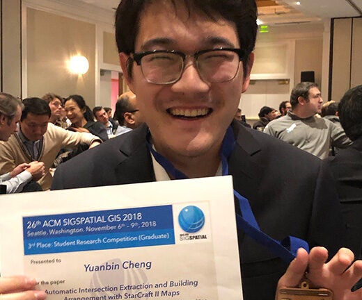
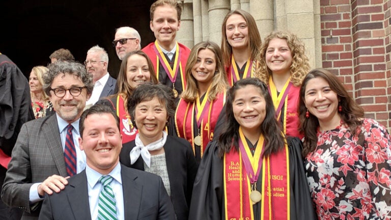
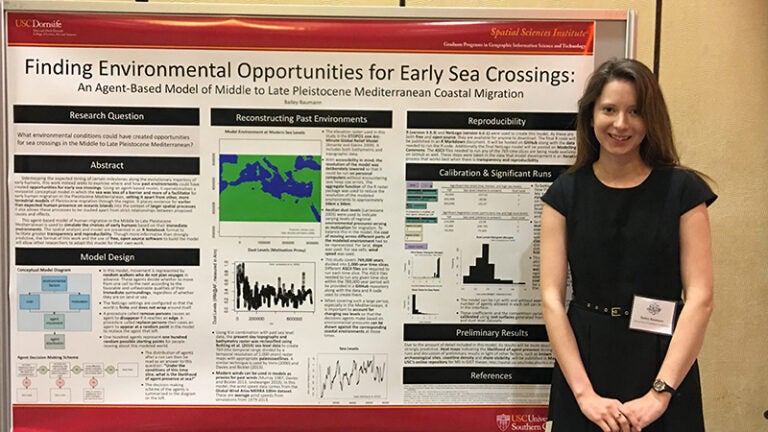
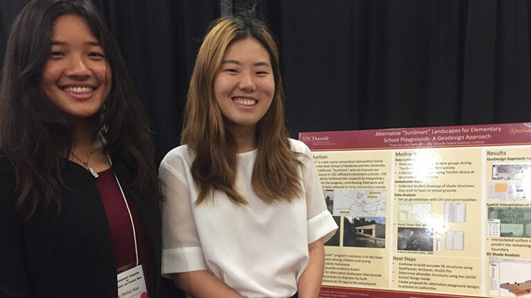


