
SSI Faculty and Students Contribute to the Analysis of GEOINT’s Renaissance
 With the theme “We Are the New Renaissance,” the United States Geospatial Intelligence Foundation (USGIF) virtually gathered industry and academic representatives at its annual GEOINTegration Summit on Monday, September 28, 2020 and Tuesday, September 29, 2020.
Co-hosts of the two-day event were Camelia Kantor, USGIF Vice President of Academic Affairs and Professional Development, and COL [R] Steven D. Fleming, Professor of the Practice with the USC Spatial Sciences Institute and the Institute for Creative Technologies. Fleming chairs the USGIF Academic Planning Committee (APC). As the USGIF APC Chair, Fleming also serves on the USGIF Academic Advisory Board.
The first Summit day opened with the “State of GEOINT Education Report" presented by Fleming and Kantor with Bradley Battista, Director of Science and Technology, Battlespace; Marco Painho, Professor, NOVA Information Management School of the Universidade Nova de Lisboa, Portugal; and Todd S. Bacastow, Teaching Professor, Penn State University. Bacastow opened the report with a reference to Dator’s Four Futures, suggesting that the future of GEOINT educational can be transformational.
Kantor described the growth in academic programs across the country in geospatial intelligence and the increased interest credentialing. Fleming examined the challenges that institutions of higher education face in offering GEOINT academic programs. Battista spoke to the Renaissance in geospatial education, as education and training becomes more closely integrated to develop a more robust pipeline of scientifically- and technologically-prepared work force. Painho reported the promising growth in the program at Universidade Nova de Lisboa could be seen as an indication of the potential of GEOINT academic programs. The panelists concurred that in the midst of disruption, change and challenges come great opportunities.
Highlights of the first day also included a poster session and lightning talks presented by students of USGIF-accredited academic programs. Representing the USC Spatial Sciences Institute M.S. in Human Security and Geospatial Intelligence program was John Pedersen (M.S. HSGI ’20) presenting the poster “Development of an Operations Dashboard Suite to Support COVID-19 Emergency Management Efforts for US Army Corps of Engineers, Los Angeles” of the research that his student team produced in the M.S. HSGI capstone course as a real-life solution to a GEOINT partner. The team developed an online operations dashboard suite for key personnel and decision-makers in making informed decisions based on peak projection modeling for the USACE South Pacific Division. The analysis in the dashboard products can be used to provide actionable intelligence to key decision-makers and stakeholders in emergency management positions in efforts to combat the healthcare system overcapacity caused by the COVID-19 disease outbreak. The dashboard product offers a visualization medium that is user-friendly and the internal mechanisms and displays can be adjusted based on the needs of the client.
Representing SSI in the lightning talks were Kevin Mercy (M.S. Geographic Information Science and Technology ’20; B.A. in Interdisciplinary Archaeology; Minors in Computer Programming and Geospatial Intelligence), Mia Poynor (B.S. Health and Human Sciences; Minors in Geospatial Intelligence and Spatial Studies ‘19) and Young-Kyung Kim (B.A. International Relations and Affairs; B.S. Computational Linguistics ’21; Minor in Human Security and Geospatial Intelligence).
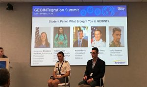
SSI’s Kevin Mercy (right) spoke on “What Brought You to GEOINT?” at the 2019 USGIF GEOINTegration Summit in Herndon, Virginia.
In his lightning talk “Comparing 3D Point Clouds in the Web: A Cloud Based Approach,” Mercy evaluated current 3D GIS capabilities and performance within the web, Esri ArcGIS Enterprise Portal, Cesium JS and Hexagon Geospatial Luciad RIA, which were all configured on a cloud-based Amazon EC2 instance to host and serve 3D tile datasets that implement adaptive tiled data structures. He used two different source point cloud datasets, a high-resolution photogrammetric dataset, a lower resolution LiDAR dataset, resource loading time and resource memory to test each system with increasing overall tileset sizes and with three different levels of zoom. His results indicated that Cesium JS would likely be most suited for complex analytic operations, while Hexagon Geospatial Luciad RIA would be best for detailed single scene visualization. Mercy won the 2019-2020 USGIF $10,000 RGi Scholarship for Geospatial and Engineering and was a 2019 recipient of the USGIF Young Professionals Gold Ticket program. He now is a GIS analyst at The Aerospace Corporation where much of his focus is on web service of imagery products.
 Poynor’s lightning talk “Leveraging Personal Electronic Device (PED) Data to Investigate Federalism and Inequality in a Pandemic” presented research she has done as part of the SSI Human Security and Geospatial Intelligence Lab. Using highly detailed individual mobility data for five Mexican states, her research team documented the relationship between local income factors, local and national policies and the effects of COVID 19. Their results emphasized the important role of federalism in the response to the crisis, especially the flow of resources from the central government and the political connections between state and national officials. In the process, they provided new indicators of inequality in life circumstances in Mexico, and how federalism impacts these differences in the COVID 19 context. Poynor recently completed Portuguese studies in Brazil as a Boren Scholar, a DoD program to provide intensive cultural immersion in areas of the world that are vital to U.S. national security interests. She received the 2020 USGIF Most Promising Female GEOINTer award.

Human Security and Geospatial Intelligence Lab
Kim’s lightning talk also presented research of the SSI HSGI Lab. Her talk entitled “Detecting Destroyed Communities in Remote Areas with Personal Electronic Device Data; a Case-Study of the 2017 Puebla Earthquake” described her team’s algorithmic approach to leverage anonymized locational data collected from personal cell phones to detect the depopulation of localities severely affected by the 2017 Puebla earthquake in Mexico. This algorithm builds a pattern of life and then detects short term migration after the earthquake, successfully identifying 73% of severely damaged localities. This individual-focused system provides a promising approach for understanding the size and severity of a humanitarian disaster and for prioritizing response and reconstruction efforts for the most vulnerable and impacted communities. Kim is in her senior year at the University of Southern California.
In the concluding session “Renaissance Education Shaped by Disruption,” SSI’s Founding Director and Professor John P. Wilson joined Anthony Robinson, Associate Professor of Geography, Penn State University; Gordana Vlahovic, Professor and Chair, North Carolina Central University; John Serafini, CEO, Hawkeye 360; and Timothy Walton, Associate Professor, James Madison University in addressing the question “What resources do universities need to deal with the consequences of the pandemic?” Wilson pointed to the added burden and cost of administration since the lockdown began, and how the extent of this remains unknown. He also offered that the Spatial Sciences Institute nevertheless on seeing through the crisis and remaining focused on renovating its GEOINT-related curriculum to stay current with industry expectations of incoming work force professionals. The panel concurred that virtual internships and year-long apprenticeships are essential experiences for students as well as the industry partners.
Before adjourning the summit, Kantor announced the 2020 USGIF GEOINTegration awards. In addition to announcing the student awards, which included recognizing SSI’s Mia Poynor as the 2020 Most Promising Female GEOINTer, Kantor shared that Fleming was the recipient of the 2020 USGIF Distinguished Service Award.
“Throughout the 2020 USGIF GEOINTegration Summit, the students and faculty of the USC Spatial Sciences Institute both contributed to and benefitted from the substantive richness of the summit program,” said Susan H. Kamei, SSI managing director. “Our undergraduate and masters students in our human security and geospatial intelligence courses were able to view the sessions as a benefit of studying with USGIF accredited programs, and we thank USGIF for making this valuable resource available to our students. We also congratulate Mia and COL Fleming on their well-deserved awards, and acknowledge the great job that COL Fleming, Dr. Wilson, John, Kevin, Mia and Young-Kyung did in representing us so well in their various roles on the program. Well done, team!” added Kamei.
To learn more about the major and minor in Human Security and Geospatial Intelligence offers USC undergraduates and about the graduate programs in HSGI, please visit spatial.usc.edu.

