
USC Spatial announces the 2020 M.S. in GIST Thesis Prize Winners
The USC Spatial Sciences Institute (USC Spatial or SSI) has announced the 2020 prizes for the top three outstanding GIST Theses by graduating students in the M.S. in Geographic Information Science and Technology (GIST) program.
Each year, the SSI faculty who serve as thesis advisors nominate theses for consideration for the prizes. A faculty committee evaluates the nominated theses for their depth of content, uniqueness of the research problem, quality of writing, overall thesis structure and relevance to solving real-world problems.
The 2020 M. S. in GIST thesis prize winners are:
- Lindsay Hennes, first place, for her thesis “Increase in Surface Temperature and Deep Layer Nitrate in the California Current: A Spatiotemporal Analysis of Four-Dimensional Hydrographic Data”;
- Sarah Halpern, second place, for her thesis“Wetland Mapping and Restoration Decision Making using Remote Sensing and Spatial Analysis: A Case Study at the Kawainui Marsh”; and
- Kevin Mercy, third place, for his thesis “Comparative 3D Geographic Web Server Development: Visualizing Point Clouds in the Web.”
 In her thesis, Hennes worked with the four-dimensional hydrographic data set created by the research group CalCOFI (the California Cooperative Oceanic Fisheries Investigations) on the Southern California Current System (SCCS). CalCOFI, initially created in 1949 to monitor sardine fisheries, now studies many more organisms and abiotic hydrographic attributes in a survey area that stretches from Point Conception to San Diego and extends approximately 700 km offshore. It encompasses a small portion of the path traversed by the California Current (CC) as it travels southward along the North American west coast.
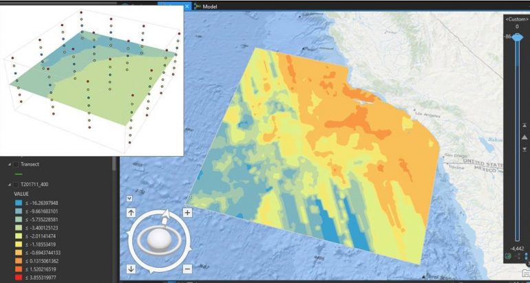
Hennes tested a hypothesis about an unexpected trend that, despite an increase in sea surface temperature (SST), primary production is increasing in the SCCS, possibly because nitrate concentration in the deep water is increasing. She created a unique workflow using Empirical Bayesian Kriging 3D and the Space Time Cube toolset in ArcGIS Pro to analyze spatial and temporal patterns in temperature and nitrate in CalCOFI’s four-dimensional hydrographic dataset. Her results show that SST and deep layer nitrate are increasing in parts of the CCS, particularly in the offshore portion of the study area. Her comparison of spatial patterns to past research suggests the California Current may be delivering increased nitrate, perhaps due to global changes to circulation in the Pacific.
Dr. Karen K. Kemp served as the thesis advisor for Hennes. Dr. Darren M. Ruddell and Dr. Su Jin Lee also served as her thesis committee members. For winning first prize, Hennes receives a cash award of $1,500 from the Spatial Sciences Institute and a certificate. Her name will be inscribed on a plaque in the USC Spatial office honoring each year’s top thesis prize winner.
In her thesis, Halpern investigated the use of unmanned aerial vehicles (UAVs) as a tool for wetlands restoration planning in a small study area. Halpern utilized a DJI Phantom 4 Pro V2 drone to acquire high-resolution imagery and a 3D point cloud of the 60-acrea Kahanaiki restoration area of the Kawainui Marsh, the largest wetlands on the Hawaiian Islands on the island of Oahu. She then classified the imagery and point cloud into variables – streams, mudflats, plant species, urban land use, and a 0.15-meter DEM and used these criteria in a suitability analysis to determine where restoration efforts are most likely to succeed. High-resolution imagery of Kahanaiki and two other current restoration sites were created for use in future monitoring. Halpern demonstrated that the use of UAVs can assist with the monitoring existing restoration areas and support planning of ideal locations for future restoration sites.
Serving as Halpern’s thesis advisor was Dr. Steven D. Fleming. Dr. Andrew J. Marx and Dr. Laura C. Loyola were her thesis committee members. In recognition of the second place prize, Halpern receives a cash award of $1,000 and a certificate.
Mercy’s thesis evaluated current 3D GIS capabilities and performance within the web, Esri ArcGIS Enterprise Portal, Cesium JS and Hexagon Geospatial LuciadRIA, which were all configured on a cloud-based Amazon EC2 instance to host and serve 3D tile datasets that implement adaptive tiled data structures. He used two different source point cloud datasets, a high-resolution photogrammetric dataset, a lower resolution LiDAR dataset, resource loading time and resource memory to test each system with increasing overall tileset sizes and with three different levels of zoom.
His results showed that while Cesium JS is quickest, Esri ArcGIS Enterprise Portal performs similarly and with more detailed visualizations for both datasets. He found that Hexagon Geospatial LuciadRIA performed slower than the other two systems, but possesses the most photorealistic and detailed rendering of the systems. He noted performance differences between the servers in the level of library compression and number of libraries imported into the page. Cesium JS is generally quickest, but most compressed and lightweight server. He concluded that overall tileset size and spatial resolution of data did not significantly impact performance while zoom level did significantly impact performance. Generally, higher resolution of zoom required more resources and loading time. His results indicated that different visualization systems are best suited for different applications: Cesium JS would likely be most suited for complex analytic operations, while Hexagon Geospatial LuciadRIA would be best for detailed single scene visualization.
Dr. Andrew J. Marx, a remote sensing expert, was Mercy’s thesis advisor. Dr. Yao-Yi Chiang and Dr. Jennifer N. Swift served as his thesis committee members.
“I have the distinct honor to offer congratulations on behalf of our faculty and staff to this year’s prize winners,” said Dr. Robert O. Vos, assistant professor (teaching) of Spatial Sciences and director of graduate studies. Vos added, “Every year, the faculty selection committee faces extremely tough decisions because of the high quality of the theses competing for the prize. This year was no exception. We felt all three were very strong and innovative, and represented our student body well.”
Reflecting on her first place prize result, Hennes said, “Doing my thesis was both the most difficult and the most valuable part of my graduate experience. During most of the GIST program, students receive a lot of tutorials and instructions to introduce geospatial methods and tools. Doing a thesis took things one step further. I was interested in mapping change over time in nutrients in a 3D volume of ocean, and no one in the literature had done that before, so I had to develop my own methods. As it turned out, this was probably the most valuable lesson - learning how to do the research, talk to experts, and build a sensible workflow without instructions will be a very useful skillset as I pursue a geospatial career.”
She added, “The structure of the thesis program and the help of a talented advisor helped keep me on track and nudge me in the right direction when I was uncertain, and provided a supportive environment to learn these skills. The one-on-one feedback and advice from advisors, teachers, and other students during the thesis process was really necessary, and I couldn't have done it in a vacuum on my own. Writing a thesis seemed very daunting at the start, but breaking it down into many smaller steps and deadlines really helped make it more manageable, and looking back, I'm really proud of the thesis I produced.”
In the thesis process, Hennes discovered another big takeaway: “After completing and presenting a project of this magnitude, I feel much more confident in my skills and proficiency as a geospatial scientist. This thesis was by far the biggest research project I've ever undertaken, so completing it expanded my own idea of what I am capable of.”
As a result of her thesis work, Hennes was selected to present at the 2019 Esri Ocean and Atmospheric GIS Forum on November 6, 2019 and at the CalCOFI 70th Anniversary Annual Oceanography Symposium on December 2, 2019.
Hennes said, “I went into these conferences feeling somewhat underqualified as a student among professionals, but I got a lot of great questions and feedback. Some people at the Esri conference were interested in applying my methods in other places. At the oceanography conference, the audience question time turned into a conversation among several respected scientists about which ocean currents or mechanisms were causing the increased nutrients I found in my results, and how it related to their own research. The moderator eventually had to cut off questions, but the discussion continued later. I was blown away and humbled by the interest people showed in my work, and it really made me realize that I can make valuable contributions to this field.”
From her perspective as the thesis advisor for Hennes, Kemp said, “Lindsay presented very complex data, methods and science with impressive clarity. Her thesis is a standard that our current and future thesis students should strive to hit. Lindsay is a wonderful ambassador for USC’s GIST Program!”
To learn more about the value of a master’s thesis from the USC Spatial Sciences Institute GIST Graduate Programs, visit https://gis.usc.edu/curriculum/masters-thesis/. To see the roster of the M.S. GIST master’s theses which have been successfully defended, visit https://spatial.usc.edu/m-s-in-gist-theses/.

