
Identifying “hot streets” to reduce crime
MS GIST Alumnus Quincy Tom-Jack publishes thesis work in the International Journal of Geo-Information
Law enforcement agencies have long used geographic information systems (GIS) to determine spatio-temporal crime patterns and have used spatial analysis to identify crime “hot spots” -- spatial clusters of high crime areas. However, existing analytical approaches did not provide law enforcement agencies with the specific information they needed to more effectively deploy patrols and other resources at the street level. As a student in the USC M.S. in Geographic Information Science and Technology (GIST) program, Quincy Tom-Jack wondered how to produce a GIS model that would identify “hot streets” instead of “hot spots.”
For his masters thesis, Tom-Jack created just such a model, using GIS-based geoprocessing to produce linear statistically significant spatial crime clusters at the street level. He recently published the results of his thesis research in the International Journal of Geo-Information.
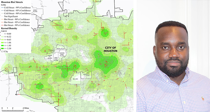
In his article “The Role of Geoprocessing in Mapping Crime Using Hot Streets”, Tom-Jack described his analysis of different crime types at varying temporal scales and in Atlanta, Georgia and Houston, Texas, classifying streets based on four crime cluster confidence levels. His research found that the geoprocessing model successfully streamlined the creation of crime hot streets in the two study areas and led to the development of multi-scale hot street maps. In addition, anyone who wants to perform linear cluster analysis in other topics can also use and edit this model for those purposes.
Co-authoring the article with Tom-Jack were his M.S. in GIST thesis advisor, Dr. Laura C. Loyola, and another one of his M.S. in GIST professors, Dr. Jennifer M. Bernstein.
“Since I started taking GIS classes during my undergraduate degree, I always enjoy performing crime analysis and thinking of new ways to automate the process for GIS users,” said Tom-Jack. “From the readings and projects I did in the USC M.S. in GIST program, I realized there was little literature written on how to perform and automate a hot spot analysis at the street level. I decided to try and create a model to accomplish this goal for my thesis,” explained Tom-Jack.
On behalf of the M.S. in GIST program, Bernstein congratulated Tom-Jack on the accomplishment of having his thesis work published. “Quincy’s work deserves recognition. And it’s always great validation of the strength of our students’ work when their research is deemed worthy of publication,” Bernstein added.
For Tom-Jack, having his research published in an academic journal represents a personal and professional milestone. “The USC M.S. in GIST program prepared me for real-world scenarios. The diverse knowledge areas of the faculty and my fellow students broadened my understanding of the possible applications of GIS. The applied nature of the program and the supportive faculty have helped me get an academic publication, create a map for a UNESCO banner in Ethiopia, and work for pipeline and utility companies within two years of my graduation,” said Tom-Jack.
Following his graduation from the USC M.S. in GIST program in 2018, Tom-Jack went into GIS consulting, working on gas pipelines at multiple cities within the state of Georgia. Upon completion of the pipeline projects, he transferred to a new project in North Dakota working for a utility company with responsibilities spanning across multiple cities within the state. He continues to enjoy working with clients to use GIS to maximize their operations.
For more information about the USC M.S. in Geographic Information Science and Technology program, visit https://gis.usc.edu/online-programs/masters-geographic-information-science-and-technology/.

