See-through Maps: Maps that Lay Bare Their Point of View is a design competition sponsored by the Global Urban Humanities Initiative, UC Berkeley and the Berkeley Center for New Media. The guidelines are, according to the organizers, intentionally ambiguous, but place the competition in the realm of the conceptual, pushing the boundaries of both what a…
Read more
Report from Catalina Vespucci Meeting Published
An international group of leaders in the health GIS field, including SSI’s Director John Wilson, have released a summary of this year’s Vespucci Institute meeting hosted by USC earlier this year on Catalina Island. The report, published in the Journal of Spatial Information Science, identifies key trends in the practice of health GIS, including: major initiatives…
Read more
Thesis research creates hyperlocal rainfall map from volunteered geographic information
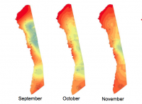
For the farmers of the Kona Region of Hawaii, specific knowledge about rainfall patterns and variability is critically important, especially in a period of environmental change. Kona is the dry side of Hawaii, with far less rain than the lush eastern side of the volcano facing the prevailing winds. GIST student Jeff Schroeder thought that…
Read more
USC Landscape Architecture Student Designs Exhibited at City Hall
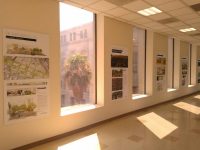
Designs re-envisioning the Los Angeles River and weaving networks of new public spaces in some of the most park-poor regions of Los Angeles are currently on display at Los Angeles City Hall. SSI Faculty Affiliate and Assistant Professor of Architecture Alexander Robinson directed the installation, which features work from his studio class focusing on the Bowtie Parcel…
Read more
