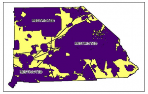
Economic incentives and political pressures have created significant demand for siting and construction of large-scale solar facilities in the California desert. Yet such industrialization of landscapes valued for the cultural significance and biological diversity can run afoul of both public opinion and be limited by environmental regulations protecting rare and endangered species. Drawing on his experience and contacts as a consultant to solar energy developers, GIST 2011 alum Ronald Lehman developed andata-driven, spatial model to help clients navigate these constraints, while also taking into account the plans of competing energy firms. In July 2013, Ronald’s work was recognized by being accepted to present at the annual Esri User Conference in San Diego.
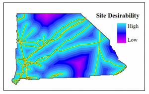
Classification of San Bernardino County by distance to power transmission lines (Lehman 2011)
Lehman was able to combine solar energy potential, industry-specific siting insights, and varying kinds of environmental constraints into a decision support tool for industry clients looking to develop projects on federal (Bureau of Land Management) lands in San Bernardino County, California. Real-world application of the model has yielded promising results.
Lehman was also recognized as the USC Esri Development Center Student of the Year in 2011. He is currently GIS Project Manager for PPC Land Consultants in Dixon, California. His thesis was advised by Professor of the Practice Karen Kemp.

