Be a frontline scholar
Our students have extensive opportunities to work directly with our faculty on their funded research projects. Read about some of the awards and recognition that our students have received for their scholarship and research results.
We circulate the call for applications to all SSI students each semester. Keep your eye out for these announcements and application deadline information in your USC email inbox.
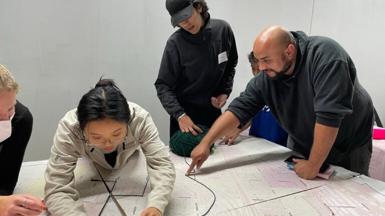
USC Urban Trees Initiative
SSI undergraduates have conducted the research for the USC Urban Trees Initiative, providing City of Los Angeles decisionmakers with data-driven and community-informed information to guide the investment in an urban forest to improve the health and quality of life in eastside communities of Lincoln Heights, El Sereno, Ramona Gardens, Boyle Heights, University Park and City Terrace.
Under the direction of SSI Founding Director and Professor John P. Wilson and SSI GIS Administrator Beau MacDonald, the 2020-2023 research teams included Rachel Ablondi, Naman Casas, Eileen Chen, Charles Curtin, Jackson FitzGerald, Jillian Gorman, Erik Huisman, Emma Johnson, Runzi Kang, Carolyn Koh, Joan Lee, Alyssa Ng and Seher Randhawa.
The undergraduate student research teams have won the 2021, 2022 and 2023 USC Schwarzenegger Institute for State and Global Policy first prize award and the 2022 and 2023 USC Sustainability Award second prize.
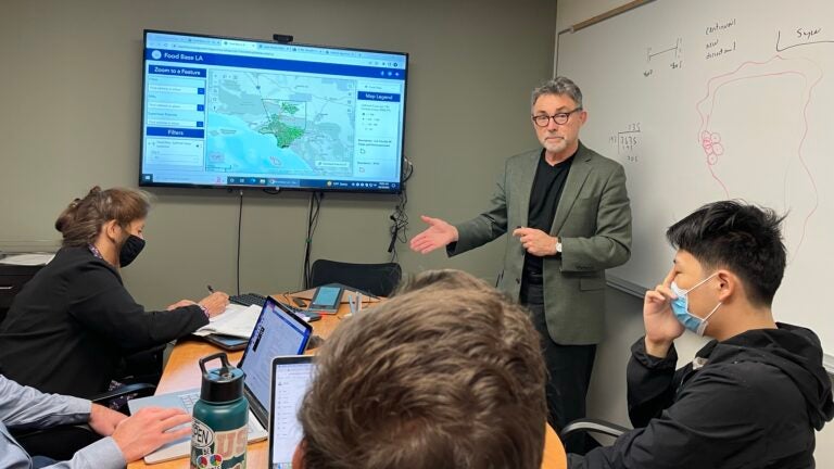
Food and Nutrition Insecurity
Funded with a $2-million National Science Foundation grant, Spatial Sciences Institute faculty and student researchers are working with LA County leaders, community organizations and private partners to build a comprehensive data portal that will give stakeholders the ability to improve access to food and nutrition resources in real time.
The project work has included incorporating a series of dashboard-type data visualizations and interactive applications, collecting qualitative and quantitative field data and data aggregation at multiple levels for visualization and analysis, from service planning areas to street corridors to aggregated data tessellations. The team has integrated 2D and 3D maps, widgets, spatial and non-spatial data like PDFs, tables, and spreadsheets and geospatial data services.
Doctoral and masters student researchers have included Matthew Bauer, Dominic Borelli, Leo Lerner, Michelle Livings, Mengya Xu and TianLiang Zhao, working with Dr. Kayla de la Haye, Dr. Wandi Bruine de Bruin, Dr. John P. Wilson and Beau MacDonald.
USC GeoHealth Data Hub
An SSI student team created and launched the USC GeoHealth Hub application, providing faculty, staff, and students affiliated with the Keck School of Medicine of USC with the ability to develop content and share related data with collaborators and the general public. Under the direction of Dr. John P. Wilson and Beau MacDonald, the student team continues to build out the portal, adding new and updated data sets and informative ArcGIS StoryMap presentations for researchers about interactive CDC geospatial tools, the process of geocoding and other tools and datasets.
With funding from Southern California Environmental Health Sciences Center, USC Institute for Addiction Science and the USC Norris Comprehensive Cancer Center, the Hub is already furthering engagement between funding agencies, decision-makers and communities.
The StoryMap presented by SSI students Amanda Rago and Shiqi Violet Li won the Esri prize for the most innovative use of technology at the 2023 Los Angeles Geospatial Summit. Other SSI students who have contributed to this project include Alicia Adiwidjaja, Naman Casas, Shuyi Deng and Felix Goldwasser.


