Connecting health, place and time
Dr. John P. Wilson discusses “Location, location, location: Using the spatial sciences to connect health and place over the life course” for the USC MESH Academy of the Keck School of Medicine of USC.

Advancing precision medicine
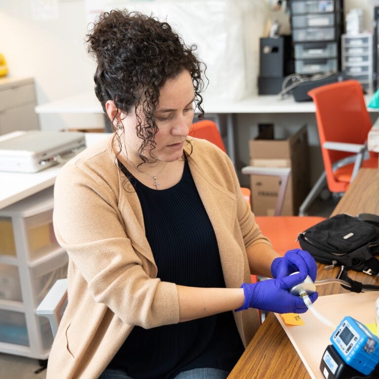
Rima Habre, associate professor of population and public health sciences and spatial sciences, is on a quest to improve Latino maternal health. As a lead investigator with the USC Maternal Developmental Risks from Environmental and Social Stressors (MADRES) Center for Environmental Health Disparities, Habre’s team has found that Hispanic women living in neighborhoods with high levels of environmental pollution early in their pregnancies have babies with lower birth weights.
With funding from the National Institute of Environmental Health Sciences, the SSI group is using innovative geospatial technology to capture personal exposures and genetic makeup to formulate individual analyses of disease risk and aid prevention efforts, expanding the boundaries of precision medicine.
Population, Health and Place Ph.D. alumni Yan Xu and Li Yi contributed to this study.
Xu, Y., Yi, L., Cabison, J., Rosales, M., O’Sharkey, K., Chavez, T., Lurmann, F., Bastain, T., Breton, C., Wilson, J.P., Habre, R., The impact of GPS-derived activity spaces on personal PM2.5 exposures in the MADRES cohort. Environment Research, 214(Part 2), 114029 (November 2022).
Yi, L., Xu, Y., Eckel, S.P., O’Connor, S., Cabison, J., Chu, D., Chavez, T., Mason, T., Bastain, T., Breton, C., Dunton, G., Wilson, J.P., Habre, R. Time-activity and daily mobility patterns during pregnancy and early postpartum: Evidence from the MADRES cohort. Spatial and Spatio-temporal Epidemiology, 41, 100502.
Optimizing food and nutrition security
Funded with a $2-million National Science Foundation grant, an interdisciplinary SSI team is building a comprehensive data portal that will give community stakeholders the ability to understand the dynamics of a county food system, enabling them to flag the issues most in need of intervention. With input from Los Angeles County leaders, community organizations and private partners, the goal is that this portal will serve as a prototype for cities and counties across the U.S. to increase food system resilience.
The project leaders are USC scientists Kayla de la Haye, director of the USC Institute for Food System Equity and adjunct associate professor (teaching) of spatial sciences; Wändi Bruine de Bruin, provost professor of public policy, psychology and behavioral science; and John P. Wilson, professor of architecture, civil & environmental engineering, computer science, population and public health sciences, sociology and spatial sciences.
SSI researchers include Population, Health and Place Ph.D. alumna Michelle Livings, Ph.D. candidates Leo Lerner and Mengya Xu, M.S. in Geographic Information Science and Technology student Matt Bauer, M.S. Spatial Data Sciences student Dominic Borelli and GIS and Sustainability Science Minor Valorie Lam.
Xu, M., Wilson, J.P., Bruine de Bruin, W., Lerner, L., Horn, Abigail L., Livings, M.S., de la Haye, K., New insights into grocery store visits among east Los Angeles residents using mobility data. Health Place. (March 15, 2024; epub ahead of print. PMID: 38492528).
de la Haye, K., Saw, H.-W., Miller, S., Bruine de Bruin, W., Wilson, J.P., Weber, K., Frazzini, A., Livings, M., Babboni, M., Kapteyn, A., Ecological risk and protective factors for food insecurity in Los Angeles County during the COVID-19 pandemic. Public Health Nutrition, 26(10), 1944-1955 (2023).
Livings, M., Bruine de Bruin, W., Wilson, J.P., Lee, B.Y., Xu, M., Weber, K., Babboni, M., de la Haye, K., Food insecurity is under-reported in surveys that ask about the past year. American Journal of Preventive Medicine, 65(4), 657-666 (2023).
Livings, M., Wilson, J.P., Miller, S., Bruine de Bruin, W., Frazzini, A., Weber, K., Babboni, M., Xu, M., Li, K., de la Haye, K., Spatial characteristics of food insecurity and food access in Los Angeles County during the COVID-19 pandemic. Food Security: The Science, Sociology and Economics of Food Production and Access to Food, 15, 1255-1271 (2023).
Supporting access to gender-affirming care
Avery Everhart (Ph.D. Population, Health and Place ’22) is an emerging scholar in transgender health and human rights.
She uses spatially explicit empirical techniques and theories and epistemologies of centering space and place for analyzing and promoting the health and well-being of transgender and gender diverse people.
Since graduating from the USC Population, Health and Place doctoral program, Everhart is Assistant Professor of GIS, Cartography & Transformation in the Department of Geography at The University of British Columbia.
Everhart, A.R., Ferguson, L., Wilson, J.P., Measuring geographic disparities in access to transgender hormone therapy in Texas: A three-step floating catchment area analysis. Spatial and Spatio-temporal Epidemiology, 45, 100585 (2023)
Everhart, A.R., Ferguson, L., Wilson, J.P. Construction and validation of a spatial database of providers of transgender hormone therapy in the US. Social Science and Medicine, 303, 115014 (2022).

Removing barriers to pediatric care
Jonathan M. Tan, assistant professor of clinical anesthesiology and spatial sciences, is spatially analyzing economic and environmental data with individual pediatric patient electronic health records to provide a deeper understanding of the social determinants of health risk factors that patients experience.
With Alicia Adiwidjaja (B.S. Geodesign ’22), Tan and his team determined that patients who came from census tracts of high social vulnerability were more likely to miss or cancel telehealth appointments. Their novel methodology to use geospatial analysis with patient population data linkage techniques has application beyond the pediatric pain unit.
Current SSI student researchers are Population, Health and Place Ph.D. students Junhong Duan and Andrew Kampfschulte, B.S. Geodesign student Kelly Kwok and B.S. Environmental Studies/GIS and Sustainability Science and Marine Biology Minor Katherine Robinson. The team is building upon the foundational research under grant support from the Anesthesia Patient Safety Foundation, the Foundation for Anesthesia Education and Research, and the Southern California Environmental Health Sciences Center.
Diallo MS, Tan JM, Heitmiller ES, Vetter TR. Achieving Greater Health Equity: An Opportunity for Anesthesiology. Anesth Analg. 134(6):1175-1184. doi: 10.1213/ANE.0000000000005937. PMID: 35110516 (2022).

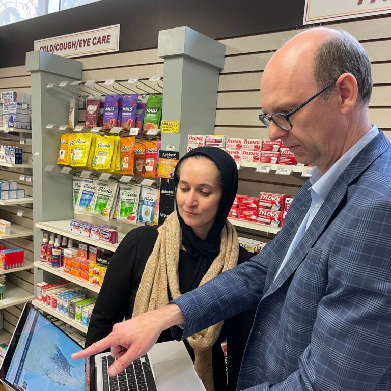
Improving health equity
One-third of neighborhoods in the largest U.S. cities—including Los Angeles—are a pharmacy desert, with Black or Hispanic/Latino communities being the most impacted neighborhoods. SSI faculty affiliate Dima M. Qato, associate professor of pharmacy, is leading an initiative to generate real-time information with spatial computing and analysis capabilities for national, state and local policy officials, health care academics, industry professionals and others.
Qato, Robert O. Vos, associate professor (teaching) of spatial sciences, and Taylor Robinson (M.S. GIST ’22), in collaboration with others in the Program on Medicines and Public Health, have developed an interactive mapping tool that shows the location of every pharmacy in the United States and pharmacy shortage areas. Their goal is to support policymakers and other leaders in developing strategies to improve pharmacy access in underserved communities with historically marginalized populations on a national scale.
The USC Leonard D. Schaeffer Center for Health Policy and Economics and the National Community Pharmacists Association, which represents independent pharmacies around the country, are among the collaborating institutions.
Guadamuz JS, Wilder JR, Mouslim MC, Zenk SN, Alexander GC, Qato DM. Fewer Pharmacies In Black And Hispanic/Latino Neighborhoods Compared With White Or Diverse Neighborhoods, 2007-15. Health Aff (Millwood). 2021 May;40(5):802-811. doi: 10.1377/hlthaff.2020.01699. PMID: 33939507 (2021).