
Geocoding for precision healthcare
Spatial Sciences Institute researchers have developed novel uses of GIS to show how multiple social and environmental determinants of health (SEDoHs) affect disease outcomes.
As part of a research team with the Southern California Clinical and Translational Science Institute (SC CTSI), SSI’s John P. Wilson and Beau MacDonald havecreated a simple-to-use, open-source resource to enrich the clinical databases of the University of Southern California and Children’s Hospital Los Angeles by incorporating SEDoH data and geographic information.
This new resource includes 42 curated, geocoded social and environmental variables from national and California governmental datasets. Researchers and practioners can search the Social and Environmental Determinants Address Enhancement (SEnDAE) toolkit for geographic matches between clinical health records and the 42 variables, while also protecting patient privacy.
In SEnDAE (pronounced “sundae”), investigators can, for example, identify patients with a specific ailment—such as asthma—and link them to geocoded addresses and environmental exposure data such as air quality or housing or other determinant data.
The project lead was Neil Bahroos, Associate Professor of Research Population and Public Health Sciences and Chief Research Informatics Officer at the Keck School of Medicine of USC. Bahroos is also the Director of the Clinical Research Informatics core at SC CTSI, which provides expertise in data integration, data sharing and data security to help drive the integration of clinical care and clinical research.
Kingsbury, P., Bahroos, N., Meeker, D., Espinoza, J., Angyan, P., Abajian, H., Abajian, M., MacDonald, B., Wilson, J.P., SEnDAE: A resource for expanding research into social and environmental determinants of health. Computer Methods and Programs in Biomedicine, 238, 107542 (2023).

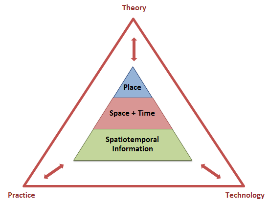
Articulating the future of spatial data science
In his book, Spatial Data Science (Esri Press, 2024), John P. Wilson outlines why and how spatial scientists and data scientists complement one another in their thought processes and methods. He calls for scientists across academic disciplines and practioners in diverse application domains to adopt and utilize the latest advances in computing, new geospatial data streams and the latest spatial methods.
Liu, X., Chen, M., Claramunt, C., Batty, M., Kwan, M.-P., Senousi, A., Cheng, T., Strobl, J., Coltekin, A., Wilson, J.P., Bandrova, T., Konecny, M., Torrens, P., Zhang, F., He, L., Wang, J., Ratti, C., Kolditz, O., Klippel, A., Li, S., Lin, H., Lü, G., Geographic information science in the era of geospatial big data: A cyberspace perspective. The Innovation, 3(5), 100279 (2022).
The focus on place, space, time and spatiotemporal information and the complementary roles of theory, practice and technology in the spatial sciences offer hope that we can achieve the United Nations’ Sustainable Development Goals before the world as we know it is irreversibly changed.
Flying over treetops
Fundamental to the Spatial Sciences Institute project funded by the Bezos Earth Fund is the ability to build comprehensive tree inventories, identifying tree locations, species and conditions across both public and private properties.
John P. Wilson and Yi Qi, associate professor (teaching) of spatial sciences, are using AI and deep learning tools to produce a county-wide tree inventory and model the impact of the existing tree canopy and new greening initiatives on land surface temperature and health.
The Wilson-Yi research team of postdoctoral fellows, masters students and undergraduate students are using LiDAR and photogrammetric data sets to measure tree loss and canopy growth as a more rapid and consistent method than hand counting and field surveilling.
Chen, M., Liu, X., Claramunt, C., Cöltekin, A., Peng, P., Lotfian, M., Robinson, A.C., Golay, F., Joost, S., Ingensand, J., Wilson, J.P., Batty, M., Kwan, M.-P., Senousi, A.M., Cheng, T., Strobl, J., Bandrova, T., Konecny, M., Torrens, P.M., Zhang, F., He, L., Wang, J., Ratti, C., Kolditz, O., Klippel, A., Li, S., Lin, H., Wang, D., Lü, G., Artificial intelligence and visual analytics in geographical space and cyberspace: Research opportunities and challenges. Earth-Science Reviews, 241, 104438 (2023).
Wolf-Jacobs, A., Wilson, J.P., Margulies, E., Promoting self-determination, minimizing green gentrification, and maximizing community benefits in urban forestry expansion: A systematic review. Urban Forestry & Urban Greening, 84, 127933.
Digital modeling of terrain
Author of Environmental Applications of Digital Terrain Modeling (John Wiley and Sons, 2018) and Terrain Analysis: Principles and Applications (John Wiley and Sons, 2000), SSI’s John P. Wilson makes extensive use of GIS software tools, field work, spatial analysis techniques and computer models to model environmental systems.
His work is cross-disciplinary and collaborative with the goal of improving knowledge and understanding of the factors linking society, the environment and human health. Wilson’s collaborators include faculty at Wuhan University and the Chinese Academy of Sciences.
Zhou, A., Chen, Y., Wilson, J.P., Chen, G., Min, W., Xu, R., A multi-terrain feature-based deep convolutional neural network for constructing super-resolution DEMs. International Journal of Applied Earth Observation and Geoinformation, 120, 103338 (2023).
Chen, Y., Chen, Y., Wilson, J.P., Yang, J., Su, H., Xu, R., A multi-factors eigenvector spatial filtering-based method for resolution-enhanced snow water equivalent estimation in the western United States. Remote Sensing, 15(15), 3821 (2023).
Yue, T.-X., Liu, Y., Du, Z.-P., Wilson, J.P., Zhao, D.-Y., Wang, Y., Zhao, N., Shi, W.-J., Fan, Z.-M., Zhao, X.-M., Zhang, Q., Huang, H.-S., Wu, Q.-Y., Zhou, W., Jiao, Y.-M., Xu, Z., Li, S.-B., Yang, Y., Fu, B.-J., Quantum machine learning of eco-environmental surfaces. Science Bulletin, 67, 1031-1033 (2022).
Quan, J., Xu, Y., Ma, T., Wilson, J.P., Zhao, N., Ni, Y. Improving surface water quality of the Yellow River Basin due to anthropogenic changes. Science of the Total Environment, 836, 155607 (2022).

 Geocoding for precision healthcare
Spatial Sciences Institute researchers have developed novel uses of GIS to show how multiple social and environmental determinants of health (SEDoH) affect disease outcomes.
As part of a research team with the Southern California Clinical and Translational Science Institute (SC CTSI), SSI’s John P. Wilson and Beau MacDonald created a simple-to-use, open-source resource to enrich the clinical databases of the University of Southern California and Children’s Hospital Los Angeles by incorporating SEDoH data and geographic information.
This new resource includes 42 curated, geocoded social and environmental variables from national and California governmental datasets. Researchers and practioners can search the toolkit called the Social and Environmental Determinants Address Enhancement (SEnDAE) toolkit for geographic matches between clinical health records and the 42 variables, while also protecting patient privacy.
In SEnDAE (pronounced “sundae”), investigators can, for example, identify patients with a specific ailment—such as asthma—and link them to geocoded addresses and environmental exposure data such as air quality or housing or other determinant data.
The project lead was Neil Bahroos, Associate Professor of Research Population and Public Health Sciences and Chief Research Informatics Officer at the Keck School of Medicine of USC. Bahroos is also the Director of the Clinical Research Informatics core at SC CTSI, which provides expertise in data integration, data sharing and data security to help drive the integration of clinical care and clinical research.
Kingsbury, P., Bahroos, N., Meeker, D., Espinoza, J., Angyan, P., Abajian, H., Abajian, M., MacDonald, B., Wilson, J.P., SEnDAE: A resource for expanding research into social and environmental determinants of health. Computer Methods and Programs in Biomedicine, 238, 107542 (2023).


