

Students of USC Spatial’s Yao-Yi Chiang win awards
Dr. Yao-Yi Chiang, Associate Professor (Research) of Spatial Sciences in the USC Spatial Sciences Institute, announced the accomplishments of two of his students in his Spatial Computing Lab.
Weiwei Duan, a Ph.D. student in computer science and spatial sciences, was one of three winners in the U.S. Geospatial Intelligence Foundation/NVIDIA’s GPU Essay Challenge. As a student from the USC Spatial Sciences Institute, an accredited program of the USGIF, Duan was eligible to write a four-page essay answering the challenge question: “If you were given dedicated access to an NVIDIA GPU-powered supercomputer, what problems could you solve?” In her winning essay, Duan proposed a spatiotemporal predictive analysis from public data using deep learning. She and the Institute received two NVIDIA Titan Xp GPUs as the prize.
“All the applications were very professional and unveiled interesting ideas on how to use the GPUs in research and/or teaching,” said Dr. Camelia Kantor, USGIF’s Director of Academic Programs. “With such strong contenders for the award it was a difficult choice. The three winners stood out because they made a strong case for using the GPUs for the benefit of their students. Both NVIDIA and USGIF are committed to supporting educators and students in their efforts to accelerate innovation. This is just another example of how our educational system can benefit from external partnerships.”
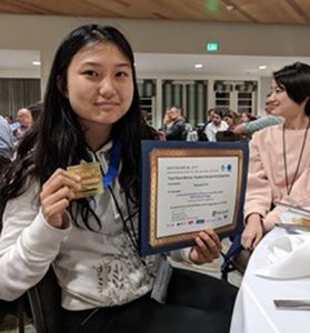 Haowen Lin, a computer science major also working with Dr. Chiang, won first place in the ACM Student Research Competition at the 2017 International Conference on Advances in Geographic Information Systems (SIGSPATIAL) for her research on “Automatic Extraction of Phrase-Level Map Labels from Historical Maps.” The competition included a short-paper submission, a poster presentation, and an oral presentation.
Chiang, Duan, USC Spatial faculty affiliate Craig Knoblock with Johannes Uhl and Stefan Leyk also recently won the best paper award for their paper Extracting Human Settlement Footprint from Historical Topographic Map Series Using Context-Based Machine Learning at the 8th International Association for Pattern Recognition Conference on Pattern Recognition Systems, Madrid, Spain, in July 2017.
Recent papers published by Chiang with numerous collaborators include:
Duan, W., Chiang, Y.-Y., Knoblock, C. A., Vinil, J., Feldman, D., Uhl, J. H., and Leyk, S., Automatic Alignment of Vector Data with Geographic Features for Feature Recognition in Historical Maps. In Proceedings of the First GeoAI Workshop, Redondo Beach, California, USA, November 2017.
Lin Y., Pan F., Chiang Y.-Y., Stripelis D., Ambite J. L., Eckel S. P., and Habre R., Mining public datasets for modeling intra-city PM2.5 concentrations at a fine spatial resolution. In Proceedings of the 25th ACM SIGSPATIAL International Conference on Advances in Geographic Information Systems (ACM SIGSPATIAL 2017), Redondo Beach, California, USA, November 2017.
Holmes-Wong, D., Chiang, Y.-Y., Unlocking Maps for Discovery and Other Purposes, Digital Library Federation (DLF) Forum, Pittsburgh, Pennsylvania, USA, October 2017.
Eckel, S. P., Deng, H., Urman, R., Habre, R., Morrison, J., Gauderman, J., Ambite, J. L., Chiang, Y.-Y., Stripelis, D., and Gilliland, F. D., Methods for Predicting Asthma Exacerbations using Personal Sensor Monitoring systems, International Society for Environmental Epidemiology (ISEE), Sydney, Australia, September 2017.
Uhl, J. H., Leyk, S., Chiang, Y.-Y., Duan, W., and Knoblock, C. A., Extracting Human Settlement Footprint from Historical Topographic Map Series Using Context-Based Machine Learning. In Proceedings of the IAPR 8th International Conference on Pattern Recognition Systems, Madrid, Spain, July 2017.
Nanetti, A., Cattaneo, A., Cheong, S.-A., Chiang, Y.-Y., and Lin, C.-Y., Visual Knowledge Aggregation: From Static to Dynamic Information Systems in Library Contexts. In Proceedings of the ICA Pre-Conference Workshop on Mapping Tools for Non-Mapping Experts: Incorporating Geospatial Visualization Tools in Libraries, Washington, D.C., USA, July 2017.
Leyk, S. and Chiang, Y.-Y., Implementing the Concept of Geographic Context for Efficient Recognition from Large-Scale Topographic Map Series. In Proceedings of the 28th International Cartographic Conference, Washington, D.C., USA, July 2017.
Chiang, Y.-Y., Linking Historical Maps to the USC Shoah Foundation Visual History Archive. In Proceedings of the 28th International Cartographic Conference, Washington, D.C., USA, July 2017.
Chiang, Y.-Y., Jain, A., Bandyopadhyay, B., Knoblock, A. C., Automatic Learning of User Design Rationales from Examples. In Proceedings of the Symposium on Solid and Physical Modeling (SPM), Berkeley, CA, USA, June 2017.
For more information on Chiang’s research, email him at yaoyic@usc.edu.

