
Catalina Island serves as a training ground for students from USC Dornsife's online graduate degree programs in geographic information science and technology.
By Richard HoopsThis summer, students in USC Dornsife’s online graduate programs in geographic information science and technology (GIST) gathered at the USC Wrigley Marine Science Center on Catalina Island to meet their classmates face-to-face and collaborate on research projects.
"For many students the week they spend on Catalina Island is the highlight of the program," said John Wilson, professor of sociology and geography, and director of the USC Spatial Sciences Institute housed in the USC Dornsife. Wilson directs the USC Dornsife GIST programs. "They find added inspiration on the island often working from sun-up until 10 or 11 at night every day they are there.”
The opportunity to meet the instructors and other students face-to-face is a critical component of the GIST distance learning program, according to Neil Storey, a workshop participant from the San Francisco Bay area.
"The workshop provided an incredible environment for learning from both the instructors and the other students, and the connections I made will carry throughout the rest of my time in the program," Storey said.
Wilson, who also holds adjunct appointments as professor in the USC School of Architecture and in the USC Viterbi School of Engineering Departments of Computer Science and Civil and Environmental Engineering, oversaw the development of the two graduate GIST programs in USC Dornsife. One is a Master of Science degree and the other a certificate program. Both were developed and offered online from the beginning, and Wilson said both have become very successful.
"We started as a small program that offered a certificate as an add-on to existing USC degrees. Now we have a fully-fledged, stand-alone master's degree in addition to the pre-existing graduate certificate program," he said.
Enrollment in individual sections of GIST classes is capped at 20 students, but more sections are added in response to demand. For example, the introductory class "Concepts for Spatial Thinking" has two sections this summer (40 students) and will have four sections this fall (80 students) and four or five sections next spring (80-100 students). Much of the demand for these online classes comes from well outside the Los Angeles metropolitan area. Wilson said more than half of the online students are from outside California — most of them elsewhere in the United States and in Canada — and a few from as far away as Singapore.
The GIST certificate requires completion of four graduate courses, and the GIST master's degree requires completion of six graduate courses plus a master's thesis. The certificate and the degree programs both provide training in global positioning systems (GPS), geographic information systems (GIS), remote sensing and geographically oriented Web services. The required course that brings students in these two programs together for a weeklong excursion to the USC Wrigley Marine Science Center is Geography 587: "GPS/GIS Field Techniques."
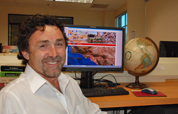
John Wilson is a professor of sociology and geography. He is director of the USC Spatial Sciences Institute and oversees USC Dornsife's online graduate programs in geographic information science and technology. Photo by Laurie Moore.
"The section of this course about field mapping is conceived, planned, conducted and reported on in the seven days they spend on the island," said Wilson.
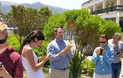
The week begins with travel to Catalina Island on a Monday, when the students meet each other and review the class to-date. The next day they meet with Isaiah Mack, a USC Dornsife alumnus (M.S., geography, '03) who holds a GIST graduate certificate, for a daylong presentation with hands-on training to learn how to use GPS for scientific data collection. Mack is GPS/GIS sales manager for California Surveying and Drafting Supply.
Afterward, students form small groups and develop research plans they can accomplish on the island. Four days later they present their results.
In one project this summer, three students used GPS tools to examine an area on the Catalina Island isthmus that burned last May in a wildfire sparked by a lawnmower.
More than 100 acres of dry vegetation burned before the fire was contained by crews from the Los Angeles County Fire Department. The student team walked the perimeter of the burn area and collected geo-spatial data related to three miles of firebreaks that helped control the fire — both pre-existing firebreaks such as roads and hiking trails, and breaks that were cleared by hand and other equipment during the blaze. They met in person with a deputy from the L.A. County Sheriff's Department in Two Harbors and spoke by phone with the L.A. County Fire Captain in Avalon for details about the outbreak and its management. The students used GPS data to map the width and locations of the firebreaks, and concluded that the presence of the firebreaks, not their width, was the critical factor that limited the spread of the fire last spring.
The students in the group, Jacki Chou, Michael Kellison and Daniel Leo, said the week-long workshop was an “invaluable and amazing experience.” They also said they enjoyed their downtime at the USC Wrigley Marine Science Center and the opportunities to hike, snorkel and kayak.
In another project, students used the varied terrain of Catalina Island to compare the accuracy of GPS receivers and GPS enabled devices under different conditions. They tested high-precision mapping-grade receivers, which are accurate to within several centimeters, as well as regular mapping-grade receivers and recreational-grade receivers sold at sporting goods stores. They also tested GPS applications on iPhone and Android smart phones. The students said the accuracy of GPS-enabled smart phones is good enough to qualify as "recreation-grade" GPS units for activities such as hiking and geocaching.
Working in the field is crucial to really understanding geographic information science and technology, Wilson said.
"In mapping science, you can read a textbook and convince yourself that it's easy. That changes when you're in the field. In this course, we let the students invent their own projects, discover their own problems and try and invent their own solutions."
The students learn how to use "checks and balances" to be sure they're using data that is relevant to the goals they're trying to reach.
"The true success of their work is shown during the final project presentations," Wilson said. "If they can say 'this is what we said we would do, this is what we've done, and — given what we know now — this is what we should have done,' that's the value added."
Participants in the project spoke highly of the weeklong workshop.
DaNiel Wood, a GIST master’s degree candidate, said that after spending a week on the island in June, he has no doubts about its value.
"It was a phenomenal learning experience, and I'm glad it was a requirement," Wood said. "Not only does it make the USC Dornsife program stand out from others, but now I can't imagine it not being mandatory. Everything about the week surpassed my expectations, and I'd welcome the opportunity to return."
Watch a video about Geography 587: GPS/GIS Field Techniques.
(See original article here)

