
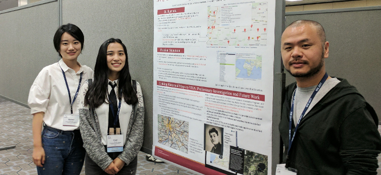
(L-R) Weiwei Duan, USC Spatial Ph.D. student, Yujin Lin, USC Spatial data scientist (research), and Yao-Yi Chiang, USC Spatial associate professor (research).
Dr. Yao-Yi Chiang and his lab use historical maps to accurately identify World War II locations in USC Shoah Foundation’s Visual History Archive
On July 5, 2017, Yao-Yi Chiang, USC Spatial Sciences Institute associate professor (research) and Yijun Lin, data scientist (research) with Chiang’s Spatial Computing Lab, presented the poster “Linking Historical Maps to the USC Shoah Foundation Visual History Archive” at the 2017 International Cartographic Conference in Washington, DC.
The research presented by Chiang and Lin is part of their project with the USC Digital Library and the USC Shoah Foundation Visual History Archive (VHA), which contains 53,000 audiovisual life stories of survivors before, during and after the Holocaust and other genocides. In the survivor videos, location information such as place names mentioned can be indexed by keywords. For example, “Poland” as the keyword in a VHA Online search box yields 5,325 results with verified locations displayed in a Google Maps web interface. Chiang’s spatial computing team addressed the issue that place names and political/administrative boundaries can change significantly over time, displaying search results on a current map that cannot portray the most accurate visualization. A number of places mentioned by survivors in their testimonies, e.g., in Poland between 1930 and 1945, cannot be located due to the lack of historical sources for verifying the location information of those places at that time. Researchers, educator, and the public have been limited in their abilities to index and conduct advance spatial queries in these records.
Using historical maps as a source of detailed place information, such as names and locations of towns, manufacturing plants, and monuments, Chiang and his team have created a number of sotry maps that link the place references in survivors’ stories to their accurate historical location, allowing the VHA stories to be indexed and searched by more detailed spatial keywords and providing a more vivid context for the personal lives of the genocide survivors.
USC Spatial Sciences Institute undergrads Leonard Ngo, Robin Franke, and Alex Chen participated in this project with support from the USC Undergraduate Research Associates Program. The USC Spatial undergraduate student researchers linked stories from survivors of the Holocaust and Rwandan genocide to historical maps found online and in libraries.
The participation of Chiang’s team at the 2017 ICC was supported in part by the U.S. National Committee (USNC) to the International Cartographic Association, in part by the National Science Foundation under Grant No. IIS 1564164, and in part by the National Endowment for the Humanities under Grant No. PR-253386-17.
The upcoming work of Chiang’s Spatial Computing Lab will build automatic approaches that find and link historical maps to VHA digital materials.
For more information about Chiang’s automatic techniques for geospatial data extraction and integration, contact him at yaoyic@usc.edu.

